Arakan
Arakan (/ˈærəkæn/ ARR-ə-kan or /ˈɑːrəkɑːn/ AR-ə-kahn[1]) is a historic coastal region in Southeast Asia. Its borders faced the Bay of Bengal to its west, the Indian subcontinent to its north and Burma proper to its east. The Arakan Mountains isolated the region and made it accessible only by the Indian subcontinent and the sea. The region now forms the Rakhine State in Myanmar.
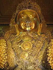
Arakan became one of the earliest regions in Southeast Asia to embrace Dharmic religions, particularly Buddhism and Hinduism. The Kingdom of Mrauk U emerged as an independent Arakanese kingdom for 300 years. During the Age of Discovery, Arakan caught the interest of the Dutch East India Company and the Portuguese Empire. In the middle of the 17th century, it was dominated by the Islamic Mughal Emperor Aurangzeb. Arakan steadily declined from the 18th century onwards after its loss to the Mughal Empire.
After conquest by the British East India Company, Arakan became one of the divisions of British India and received settlers from the neighboring Chittagong Division of the Bengal Presidency. In 1937, it became a division of British Burma. Arakan Division was once a leading rice exporter. During the Second World War, the region was occupied by Imperial Japan. The Allied Forces liberated Arakan during the Burma Campaign. It continued to be an administrative division after Burmese independence; and later became a province. In the early 1960s, the northern part of Arakan was governed from Rangoon as the Mayu Frontier District.
In 1982, the Burmese nationality law stripped many inhabitants of the region of their citizenship. In 1989, the Burmese military junta changed the official name of Burma
to Myanmar. In the 1990s, the junta changed the name of Arakan State to Rakhine State — a name reflecting the dominance of the Rakhine majority.[2] Many in the Rohingya minority strongly opposed the change. The region has seen conflict between the Burmese state, Rakhine nationalists and Rohingya rebels. In more recent times, Rakhine State has been notable for the exodus of refugees into neighboring countries because of military operations by the Tatmadaw (Myanmar Armed Forces).
Etymology
Claudius Ptolemy identified Arakan as Argyré.[3] Portuguese records spelled the name as Arracao.[4] The name was spelled as Araccan in many old European maps and publications.[5] The region was named as Arakan Division during British rule in Burma.[6]
History
_no_primeiro_plano_o_bairro_portugu%C3%AAs.jpg.webp)
Early inhabitants
It is unclear who the earliest inhabitants were; some historians believe the earliest settlers included the Burmese Mro tribe but there is a lack of evidence and no clear tradition of their origin or written records of their history.[7] Burmese traditional history holds that Arakan was inhabited by the Rakhine since 3000 BCE.[8]: 17 According to British historian Daniel George Edward Hall, who wrote extensively on the history of Burma, the Burmese do not seem to have settled in Arakan until possibly as late as the tenth century AD.[9]
Dhanyawadi
Arakanese legends claim that the history of the Arakanese people began in 3250 BC, although archaeological evidence supporting this claim is unavailable. "The presently dominant Rakhine are a Tibeto-Burman race, the last group of people to enter Arakan during 10th century and on.” (Pamela; The Lost Kingdom, Bangkok, 2002, P-5)]. Various Arakanese kingdoms stretched from the Ganges Delta to Cape Negrais on the Irrawaddy Delta.
Ancient Dhanyawadi lies west of the mountain ridge between the Kaladan and Le-mro rivers. Dhannyawadi could be reached by small boat from the Kaladan via its tributary, the Tharechaung. Its city walls were made of brick, and form an irregular circle with a perimeter of about 9.6 kilometres (6.0 miles), enclosing an area of about 4.42 km2 (1,090 acres). Beyond the walls, the remains of a wide moat, now silted over and covered by paddy fields, are still visible in places. The remains of brick fortifications can be seen along the hilly ridge which provided protection from the west. Within the city, a similar wall and moat enclose the palace site, which has an area of 26 hectares (64 acres), and another wall surrounds the palace itself.
At times of insecurity, when the city was subject to raids from the hill tribes or attempted invasions from neighbouring powers, there would have been an assured food supply enabling the population to withstand a siege. The city would have controlled the valley and the lower ridges, supporting a mixed wet-rice and taungya (slash and burn) economy, with local chiefs paying allegiance to the king.
From aerial photographs we can discern Dhannyawadi's irrigation channels and storage tanks, centred at the palace site. Throughout the history of Rakhine, and indeed the rest of early Southeast Asia, the king's power stemmed from his control of irrigation and water storage systems to conserve the monsoon rains and therefore to maintain the fertility and prosperity of the land. In ceremonies conducted by Indian Brahmins the king was given the magic power to regulate the celestial and terrestrial forces to control the coming of the rains which would ensure the continuing prosperity of the kingdom.
Vesali (Waithali)
It has been estimated that the centre of power of the Arakanese world shifted from Dhanyawadi to Waithali in the 4th century AD. Although it was established later than Dhanyawadi, Waithali is the most Indianized of the four Arakanese kingdoms to emerge. Like other Arakanese kingdoms, the Kingdom of Waithali was based on trade between the East (pre-Pagan Myanmar, Pyu, China, the Mons), and the West (India, Bengal, Persia).
The Anandachandra Inscriptions that date back to 729 AD, originally from Vesali (now preserved at Shitethaung), indicates adequate evidence for the earliest foundation of Buddhism and the subjects of the Waithali Kingdom practised. Dr. E. H. Johnston's analysis reveals a list of kings which he considered reliable beginning from Chandra dynasty. The western face inscription has 72 lines of text recorded in 51 verses describing the Anandachandra's ancestral rulers. Each face recorded the name and ruling period of each king who were believed to have ruled over the land before Anandachandra.
Important but badly damaged life-size Buddha images were recovered from Letkhat-Taung, a hill east of the old palace compound. These statues are invaluable in helping to understand the Waithali architecture, and also the extent of Hindu influence in the kingdom.
According to local legend, Shwe-taung-gyi (lit. Great Golden Hill), a hill northeast of the palace compound maybe a burial place of a 10th-century Pyu king.
The rulers of the Waithali Kingdom were of the Chandra dynasty, because of their usage of Chandra on the Waithali coins. The Waithali period is seen by many as the beginning of Arakanese coinage - which was almost a millennium earlier than the Burmese. On the reverse of the coins, the Srivatsa (Arakanese/Burmese: Thiriwutsa), while the obverse bears a bull, the emblem of the Chandra dynasty, under which the name of the King is inscribed in Sanskrit.
Indo-Islamic influence
After the Burmese invasion, Min Saw Mon fled to Gaurh in the Bengal Sultanate, where he stayed in exile for 24 years after being granted asylum by Sultan Ghiyasuddin Azam Shah. The Bengal Sultanate was one of the major Islamic states established after the Muslim conquest of the Indian subcontinent.
In 1430, Min Saw Mon regained control of Arakan with help from the Bengal Sultanate. He established his new capital in the city of Mrauk U. Arakan became a vassal state of the Bengal Sultanate and recognized Bengali sovereignty over some territory of northern Arakan. Arakanese kings adopted Islamic titles and struck the Bengali taka. Min Saw Mon was styled as Suleiman Shah. Bengalis settled in Arakan and formed their settlements.[8]: 20 [10][11]
Kingdom of Mrauk U
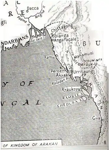
Min Saw Mon's successors in the Kingdom of Mrauk U sought to end the Bengal Sultanate's hegemony. Min Khayi was the first to challenge Bengali hegemony. Ba Saw Phyu defeated Bengal Sultan Rukunuddin Barbak Shah in 1459. Min Bin conquered Chittagong. Taking advantage of the Mughal Empire's invasion campaign of Bengal, the Arakan navy and pirates dominated a coastline of 1000 miles, spanning from the Sundarbans to Moulmein. The kingdom's coastline was frequented by Arab, Dutch, Danish and Portuguese traders. Control of the Kaladan River and Lemro River valleys led to increased international trade, making Mrauk U prosperous. The reigns of Min Phalaung, Min Rajagiri, and grandson Min Khamaung strengthened the wealth and power of Mrauk U.[8]: 20–21 Arakan colluded in the slave trade with the Portuguese settlement in Chittagong. After conquering the port city of Syriam in the early 1600s, Arakan appointed the Portuguese mercenary Philip De Brito e Nicota as the governor of Syriam. But Nicota later transferred Syriam to the authority of Portuguese India.[8]: 21
.jpg.webp)
Even after independence from the Sultans of Bengal, the Arakanese kings continued the custom of maintaining Muslim titles.[12] They compared themselves to Sultans and fashioned themselves after Mughal rulers. They also continued to employ Indians and Muslims in prestigious positions within the royal administration.[13] The court adopted Indian and Islamic fashions from neighbouring Bengal.[13][10] Mrauk U hosted mosques, temples, shrines, seminaries and libraries.[8]: 22 Syed Alaol was a renowned poet of Arakan.[14] Indian and Muslim influence continued on Arakanese affairs for 350 years.
In 1660, Shah Shuja, the brother of Emperor Aurangzeb and a claimant of the Peacock Throne, received asylum in Mrauk U. Members of Shuja's entourage were recruited in the Arakanese army and court. They were kingmakers in Arakan until the Burmese conquest.[15] Arakan suffered a major defeat to the forces of Mughal Bengal during the Battle of Chittagong in 1666, when Mrauk U lost control of southeast Bengal. The Mrauk U dynasty's reign continued until the 18th century.
Burmese conquest
The Konbaung Dynasty conquered Arakan in 1784. Mrauk U was devastated during the invasion.[8]: 22 The Burmese Empire executed thousands of men and deported a considerable portion of people from the Arakanese population to central Burma.[16]
British Empire
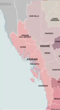
The Burmese Empire ceded Arakan to the British East India Company in the 1826 Treaty of Yandabo. Arakan became one of the divisions of British India. Initially governed as part of the Bengal Presidency, it received many settlers from neighboring Chittagong Division. The settlers became influential in commerce, agriculture and shipping. In 1937, Arakan became part of Burma Province, which was separated from India into a distinct crown colony. During World War II, Arakan endured the Japanese occupation of Burma. The Burma National Army and the pro-British V Force were active in the region. Sectarian tensions flared during the Arakan massacres in 1942. Japanese rule ended with the successful Burma Campaign by Allied forces.
During British rule, Arakan Division was one of the largest rice exporters in the world.[17] The division's seaport and capital Akyab were dominated by Arakanese Indians, which caused tension with Arakanese Burmese.[18] Both groups were represented as natives in the Legislative Council of Burma and the Legislature of Burma. In the 1940s, Arakanese Muslims appealed to Muhammad Ali Jinnah to incorporate the townships of the Mayu River valley into the Dominion of Pakistan.[19]
Burmese independence
Arakan became one of the Union of Burma's divisions after independence from British rule. Burma was a parliamentary democracy until the 1962 Burmese coup d'état. The northern part of Arakan was governed by the central government in Rangoon in the early 1960s. Known as the Mayu Frontier District, it covered townships near the border with East Pakistan.
In 1982, the Burmese junta enacted the Burmese nationality law which did not recognize Arakanese Indians as one of Burma's ethnic groups, thereby stripping them of their citizenship. In 1989, the Burmese government altered the country's name from Burma to Myanmar. In the 1990s, the State Peace and Development Council changed the name of Arakan State to Rakhine State. The province was renamed after the Rakhine ethnic group. However, the new name is not accepted as legitimate by many in both the Rakhine and Rohingya communities, instead preferring the historical term Arakan.
Rakhine-led groups like the Arakan Liberation Army have sought independence for the region. Other groups, including the Arakan Rohingya National Organization, have demanded autonomy. The region witnessed military crackdowns during Operation King Dragon in 1978; in 1991 and 1992 after the 8888 uprising and 1990 Burmese general election; the 2012 Rakhine State riots, the 2015 Rohingya refugee crisis and Rohingya persecution in Myanmar (2016-present).
Geography
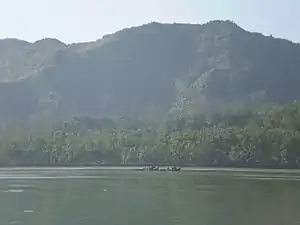
Arakan is a coastal geographic region in Lower Burma. It comprises a long narrow strip of land along the eastern seaboard of the Bay of Bengal and stretches from the Naf River estuary on the border of the Chittagong Hills area (in Bangladesh) in the north to the Gwa River in the south. The Arakan region is about 400 miles (640 km) long from north to south and is about 90 miles (145 km) wide at its broadest. The Arakan Mountains (also called Arakan Yoma), a range that forms the eastern boundary of the region, isolates Arakan from the rest of Burma. The coast has several sizable offshore islands, including Cheduba and Ramree. The region's principal rivers are the Nāf estuary and the Mayu, Kaladan, and Lemro rivers. One-tenth of Arakan's generally hilly land is cultivated. Rice is the dominant crop in the delta areas, where most of the population is concentrated. Other crops include fruits, chilies, dha and tobacco.[20]
The main towns are coastal and include Sittwe (Akyab), Sandoway, Kyaukpyu and Taungup.[20]
Demographics
The people of Arakan have historically been called the Arakanese. The population consists of Tibeto-Burmans and Indo-Aryans. Tibeto-Burman Arakanese mostly speak the Arakanese language, also known as Rakhine and closely related to Burmese. Most Indo-Aryan Arakanese speak the Rohingya language. Other languages spoken by smaller communities in Rakhine state include the Tibeto-Burman Chak, Asho Chin, Ekai, Kumi, Laitu, Mru, Songlai, Sumtu and Uppu, as well as the Indo-Aryan Chakma.[21]
The government of Myanmar recognizes Tibeto-Burman Arakanese as the Rakhine people. It also recognizes sections of the Muslim community, including the Kamein. But Myanmar does not recognize the Rohingya.
Arakan Division had the largest percentage of Indians in British Burma.[22]
References
- Columbia Encyclopedia, s.v. "Rakhine State".
- "Arakanese - Definition, Location, & Ancient Kingdom".
- Arthur Purves Phayre (1883). History of Burma. Рипол Классик. p. 42. ISBN 978-5-87742-763-1.
- Frederick Charles Danvers (1988). The Portuguese in India: Being a History of the Rise and Decline of Their Eastern Empire. Asian Educational Services. p. 528. ISBN 978-81-206-0391-2.
- Thomas Bankes; Edward Warren Blake; Alexander Cook; Thomas Lloyd (1800). A New, Royal, and Authentic System of Universal Geography, Ancient and Modern: Including All the Late Important Discoveries ... and a Genuine History and Description of the Whole World ... Together with a Complete History of Every Empire, Kingdom, and State ... to which is Added a Complete Guide to Geography, Astronomy, the Use of the Globes, Maps ... p. 247.
- Cheng Siok-Hwa (2012). The Rice Industry of Burma, 1852-1940: (First Reprint 2012). Institute of Southeast Asian Studies. p. 86. ISBN 978-981-230-439-1.
- Beniison, J.J (1933). Census of India, 1931: Burma Part I – Report. Rangoon: Office of Superintendent, Government Printing and Stationery, Burma. p. 149.
- William J. Topich; Keith A. Leitich (9 January 2013). The History of Myanmar. ABC-CLIO. ISBN 978-0-313-35725-1.
- D. G. E Hall, A History of South East Asia, New York, 1968, P. 389.
- Aye Chan 2005, p. 398.
- Yegar 2002, p. 23.
- Yegar 2002, pp. 23–24.
- Yegar 2002, p. 24.
- Francesca Orsini; Katherine Butler Schofield (5 October 2015). Tellings and Texts: Music, Literature and Performance in North India. Open Book Publishers. p. 424. ISBN 978-1-78374-102-1.
- Mohamed Nawab Mohamed Osman (19 June 2017). Islam and Peacebuilding in the Asia-Pacific. World Scientific. p. 24. ISBN 978-981-4749-83-1.
- Aye Chan 2005, p. 399.
- Georg Hartwig (1863). The Tropical World: a Popular Scientific Account of the Natural History of the Animal and Vegetable Kingdoms in the Equatorial Regions. Longman, Green, Longman, Roberts, and Green. p. 159.
- Christopher Alan Bayly; Timothy Norman Harper (2005). Forgotten Armies: The Fall of British Asia, 1941-1945. Harvard University Press. p. 91. ISBN 978-0-674-01748-1.
- Yegar 1972, p. 10.
- The Editors (1959-08-21). "Arakan | state, Myanmar". Britannica.com. Retrieved 2017-09-18.
- Eberhard, David M.; Simons, Gary F.; Fennig, Charles D., eds. (2019). "Myanmar – Languages". Ethnologue. SIL International.
- Robert H. Taylor (1987). The State in Burma. C. Hurst & Co. Publishers. pp. 126–127. ISBN 978-1-85065-028-7.
External links
 Media related to Arakan at Wikimedia Commons