Avondale, Louisiana
Avondale is a census-designated place (CDP) in Jefferson Parish, Louisiana, United States, on the west bank of the Mississippi River. The population was 4,954 at the 2010 census,[1] and 5,321 at the 2019 American Community Survey.[2] It is part of the New Orleans–Metairie–Kenner metropolitan statistical area.
Avondale, Louisiana | |
|---|---|
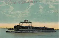 Postcard photo of the Southern Pacific railroad barge Mastodon crossing the Mississippi River at Avondale, Louisiana. The railroad also had railroad ferries which worked in the San Francisco area for the same purpose. | |
  Avondale  Avondale | |
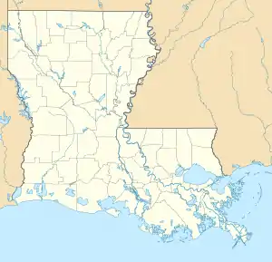
| Coordinates: 29°54′16″N 90°12′15″W | |
| Country | United States |
| State | Louisiana |
| Parish | Jefferson |
| Area | |
| • Total | 6.0 sq mi (15.5 km2) |
| • Land | 5.6 sq mi (14.4 km2) |
| • Water | 0.4 sq mi (1.1 km2) |
| Elevation | 3 ft (0.9 m) |
| Population (2019) | |
| • Total | 5,321 |
| • Density | 891/sq mi (344.2/km2) |
| Time zone | UTC-6 (CST) |
| • Summer (DST) | UTC-5 (CDT) |
| ZIP Code | 70094 |
| Area code(s) | 504 |
| FIPS code | 22-03810 |
| GNIS feature ID | 542944 |
Geography
Avondale is located at 29°54′16″N 90°12′15″W[1] on the south side ("West Bank") of the Mississippi River. It is bordered to the west by Waggaman and to the east by Bridge City, while to the north, across the Mississippi, it is bordered by the city of Harahan. The closest road crossing of the Mississippi is the Huey P. Long Bridge 4 miles (6 km) northeast of Avondale, carrying U.S. Route 90. Downtown New Orleans is 13 miles (21 km) northeast of Avondale by road.
According to the United States Census Bureau, the Avondale CDP has a total area of 6.0 square miles (15.5 km2), of which 5.6 square miles (14.4 km2) are land and 0.42 square miles (1.1 km2), or 7.23%, are water.[3]
Demographics
The 2019 American Community Survey reported there were 5,321 people and 1,729 households residing in the census-designated place.[2] Of the population in 2019, there were 1,729 households spread among 1,838 housing units. The average family size was 3.72.
In 2019, the racial and ethnic makeup of the CDP was 40.3% non-Hispanic white, 35.4% Black or African American, 15.9% Asian, 1.2% some other race, 0.2% two or more races, and 9.0% Hispanic and Latin American of any race. An estimated 14.0% of its population was foreign-born, and the median age was 36.7. Other than English, 8.3% of the population spoke Spanish, 16.4% Asian and Pacific Islander languages, and 1.8% other Indo-European languages.
The median income for a household in the CDP was $40,503, up from $35,917 at the 2000 U.S. census; approximately 14.8% of the population lived at or below the poverty line, up from 17.3% in 2000.[4]
Education
Jefferson Parish Public Schools operates public schools.[5]
Most residents are zoned to Catherine Strehle Elementary School in Avondale and some are zoned to Lucille Cherbonnier/Norbert Rillieux Elementary School in Waggaman.[6] All residents are zoned to Henry Ford Middle School in Avondale and L.W. Higgins High School in Marrero.[7][8] In regards to advanced studies academies, residents are zoned to the Marrero Academy.[9]
Previously a portion of the community was zoned to Norbert Rillieux Elementary in Waggaman.[10] In 2012 the school board announced Rillieux was being considered for consolidation into Lucille Cherbonnier Elementary.[11]
References
- "US Gazetteer files: 2010, 2000, and 1990". United States Census Bureau. 2011-02-12. Retrieved 2011-04-23.
- "Geography Profile: Avondale CDP, Louisiana". data.census.gov. Retrieved 2021-08-12.
- "Geographic Identifiers: 2010 Census Summary File 1 (G001): Avondale CDP, Louisiana". American Factfinder. U.S. Census Bureau. Archived from the original on February 13, 2020. Retrieved June 29, 2018.
- "U.S. Census website". United States Census Bureau. Retrieved 2008-01-31.
- "2010 CENSUS - CENSUS BLOCK MAP: Avondale CDP, LA" (Archive). U.S. Census Bureau. Retrieved on May 19, 2014.
- "Elementary School Districts 2012-2013 West Bank of Jefferson Parish Louisiana" (Archive). Jefferson Parish Public Schools. Retrieved on May 18, 2014.
- "Middle School Districts 2012-2013 West Bank of Jefferson Parish Louisiana" (Archive). Jefferson Parish Public Schools. Retrieved on May 18, 2014.
- "High School Districts 2012-2013 West Bank of Jefferson Parish Louisiana" (Archive). Jefferson Parish Public Schools. Retrieved on May 18, 2014.
- "Westbank Advanced Studies Academies Attendance Zones" (Archive). Jefferson Parish Public Schools. Retrieved on May 18, 2014.
- "Elementary School Districts 2009-2010 West Bank of Jefferson Parish Louisiana" (). Jefferson Parish Public Schools. Retrieved on May 18, 2014.
- Waller, Mark. "Jefferson Parish school officials announce five schools for possible closure." The Times Picayune. January 18, 2012. Retrieved on May 19, 2014.
External links
 |
Wikimedia Commons has media related to Avondale, Louisiana. |
 |
Wikivoyage has a travel guide for Avondale. |
Municipalities and communities of Jefferson Parish, Louisiana, United States | ||
|---|---|---|
| Cities |  | |
| Towns | ||
| CDPs | ||
| Other unincorporated communities | ||
| ||


Authority control  |
|---|