Batek Island
Batek Island is a small uninhabited island located in the Savu Sea, northwest of the island of Timor, 9.3 km (5.8 mi) off the East Timorese municipality of Oecusse. The sovereignty of the island had been disputed between Indonesia and East Timor.[1][2]
Native name: Pulau Batek Fatu Sinai | |
|---|---|
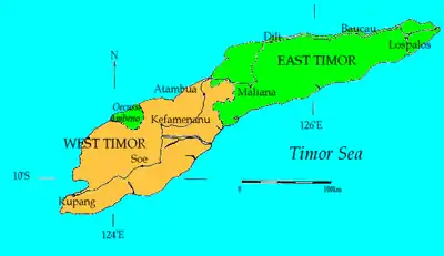  Batek Island Location in Timor | |
| Geography | |
| Location | Savu Sea |
| Coordinates | 9°15′24″S 123°59′35″E |
| Area | 0.135 sq mi (0.35 km2) |
| Length | 500 m (1600 ft) |
| Width | 320 m (1050 ft) |
| Highest elevation | 50 m (160 ft) |
| Administration | |
| Province |  East Nusa Tenggara East Nusa Tenggara |
It is 530 meters long and 420 meters wide, for an area of 13.5 hectares. Its highest point is fifty meters above sea level.
At the time of the independence of East Timor in 2002, this country claimed the island because it faced the East Timorese enclave of Oecusse. In 2004, Indonesian Colonel Moesanip said that this claim was abandoned when the East Timorese Minister of Foreign Affairs, José Ramos-Horta, recognized Indonesian sovereignty over the island.[3]
References
- "Country profile: Indonesia". www.acpp.org. June 2007. Archived from the original on 11 January 2011.
- "Fatu Sinai Island". Oecusse.com. Archived from the original on 5 July 2008.
- "Batek island belongs to Indonesia, E Timor FM says", Antara, 18 août 2004.
This article is issued from Wikipedia. The text is licensed under Creative Commons - Attribution - Sharealike. Additional terms may apply for the media files.