Bega Valley Shire
The Bega Valley Shire is a local government area located adjacent to the south-eastern coastline of New South Wales, Australia. The Shire was formed in 1981 with the amalgamation of the Municipality of Bega, Imlay Shire and Mumbulla Shire,[4] with its name deriving from the town of Bega. The shire is also known as the Sapphire Coast for tourism and marketing purposes. During the 2019–20 Australian bushfire season, the area was devastated by fire, with 448 houses being destroyed by fire[5] and approximately 365,000 hectares burned, which is 58% of the Shire's total land mass.[6]
| Bega Valley New South Wales | |||||||||||||||
|---|---|---|---|---|---|---|---|---|---|---|---|---|---|---|---|
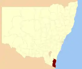 Location in New South Wales | |||||||||||||||
| Coordinates | 36°40′S 149°50′E | ||||||||||||||
| Population |
| ||||||||||||||
| • Density | 5.2959/km2 (13.7163/sq mi) | ||||||||||||||
| Established | 1981 | ||||||||||||||
| Area | 6,279 km2 (2,424.3 sq mi) | ||||||||||||||
| Mayor | Russell Fitpatrick (Mayor) Anthony McMahon (CEO) | ||||||||||||||
| Council seat | Bega[3] | ||||||||||||||
| Region | South Coast | ||||||||||||||
| State electorate(s) | |||||||||||||||
| Federal division(s) | Eden-Monaro | ||||||||||||||
 | |||||||||||||||
| Website | Bega Valley | ||||||||||||||
| |||||||||||||||
The estimated population as at the 2016 census was 33,253.[1]
Area
The shire covers 6,040 square kilometres (2,330 sq mi), and includes a coastline of 225 km (140 mi), with 101 beaches and 26 estuaries. Around 78% of the area belongs to various national parks and state forests. The biggest industry is the production of timber, followed by dairy farming and other agriculture. Smaller industries include fishing, oyster harvesting, and tourism.[7] The Biamanga National Park includes important Aboriginal sites.[8]
Towns and localities
The area extends from Bermagui in the north to the Victorian border in the south and includes the towns of Bega, Tathra, Merimbula, Tura Beach, Wolumla, Cobargo, Bemboka, Pambula, Pambula Beach and the former whaling port, tourism hotspot, and major port of Eden.
Smaller localities include:
- Angledale
- Bald Hills
- Barragga Bay
- Berrambool
- Black Range
- Bournda
- Boydtown
- Broadwater
- Brogo
- Buckajo
- Burragate
- Candelo
- Chinnock
- Coolagolite
- Coopers Gully
- Cuttagee
- Devils Hole
- Dignams Creek
- Doctor George Mountain
- Edrom
- Frogs Hollow
- Greendale
- Greigs Flat
- Jellat Jellat
- Kalaru
- Kameruka
- Kanoona
- Kiah
- Kingswood
- Lochiel
- Millingandi
- Mirador
- Mogareeka
- Mogilla
- Morans Crossing
- Mount Darragh
- Murrah
- Myrtle Mountain
- Narrabarba
- Nelson
- Nethercote
- New Buildings
- Nullica
- Numbugga
- Nungatta (part)
- Nungatta South
- Pericoe
- Quaama
- Reedy Swamp
- Rocky Hall
- South Pambula
- South Wolumla
- Stony Creek
- Tanja
- Tantawangalo
- Tarraganda
- Timbillica
- Toothdale
- Towamba
- Verona
- Wallagoot
- Wandella
- Wapengo
- Wonboyn
- Wyndham
- Yellow Pinch
- Yowrie
Council
Bega Valley Shire Council is composed of nine councillors elected proportionally as one entire ward. All councillors are elected for a fixed four-year term of office. The mayor is elected by the councillors at the first meeting of the council. The most recent mayoral election was held on 6 May 2020 at an extraordinary meeting of council, and the makeup of the council is as follows:[9][10] for the remainder of the mayoral term until September 2020.
| Party | Councillors | |
|---|---|---|
| Independents and Unaligned | 8 | |
| The Greens | 1 | |
| Total | 9 | |
The current Council, elected in 2016, in order of election, is:[9]
| Councillor | Party | Notes | |
|---|---|---|---|
| Tony Allen | Independent | ||
| Robin Bain | Independent | ||
| Kristy McBain | Unaligned | ||
| Jo Dodds | Independent | ||
| Sharon Tapscott | Independent | Mayor | |
| Russell Fitzpatrick | Independent | Deputy Mayor | |
| Liz Seckold | Independent | ||
| Mitchell Nadin | Unaligned | ||
| Cathy Griff | Greens | ||
Demographics
| Selected historical census data for Bega Valley Shire local government area | ||||||
|---|---|---|---|---|---|---|
| Census year | 2011[11] | 2016[1] | ||||
| Population | Estimated residents on census night | 31,950 |  33,253 33,253 | |||
| LGA rank in terms of size within New South Wales | 56th |  57th 57th | ||||
| % of New South Wales population | 0.46% | 0.44% | ||||
| % of Australian population | 0.15% | 0.14% | ||||
| Cultural and language diversity | ||||||
| Ancestry, top responses | English | 32.5% | 31.9% | |||
| Australian | 31.3% | 30.9% | ||||
| Irish | 9.3% | 9.2% | ||||
| Scottish | 8.4% | 8.2% | ||||
| German | 3.8% | 3.7% | ||||
| Language, top responses (other than English) | German | 0.6% | 0.5% | |||
| Dutch | 0.3% | 0.2% | ||||
| Italian | 0.2% |  0.2% 0.2% | ||||
| French | 0.2% | 0.2% | ||||
| Thai | n/r | 0.2% | ||||
| Religious affiliation | ||||||
| Religious affiliation, top responses | No religion, so described | 26.7% | 35.1% | |||
| Anglican | 27.3% | 21.9% | ||||
| Catholic | 20.0% | 17.9% | ||||
| Not stated | n/r | 10.4% | ||||
| Uniting Church | 4.6% | 3.7% | ||||
| Median weekly incomes | ||||||
| Personal income | Median weekly personal income | A$454 | A$538 | |||
| % of Australian median income | 78.7% | 81.3% | ||||
| Family income | Median weekly family income | A$1,014 | A$1,242 | |||
| % of Australian median income | 68.5% | 71.6% | ||||
| Household income | Median weekly household income | A$848 | A$986 | |||
| % of Australian median income | 68.7% | 68.6% | ||||
References
- Australian Bureau of Statistics (27 June 2017). "Bega Valley (A)". 2016 Census QuickStats. Retrieved 9 July 2017.

- "3218.0 – Regional Population Growth, Australia, 2017-18". Australian Bureau of Statistics. 27 March 2019. Retrieved 27 March 2019. Estimated resident population (ERP) at 30 June 2018.
- "Bega Valley Shire Council". New South Wales Division of Local Government. Archived from the original on 7 September 2006. Retrieved 14 November 2006.
- "Holdings". Bega Valley Genealogy Society. Bega Valley Genealogy Society Inc. Retrieved 21 May 2016.
- McKnight, Albert (18 March 2020). "Forty per cent of fire-destroyed homes haven't registered for free clean-up: Bega council". Bega District News. Retrieved 3 September 2021.
- McKnight, Albert (29 February 2020). "As summer ends, new figures reveal how much of the South Coast has been burnt". Illawarra Mercury. Retrieved 3 September 2021.
- "About the Bega Valley Shire". About the Shire. Bega Valley Shire Council. n.d. Retrieved 1 April 2018.
- "Biamanga Cultural area". NSW National Parks. Retrieved 20 August 2021.
- "Bega Valley Shire Council: Summary of First Preference Votes for each Candidate". Local Government Elections 2016. Electoral Commission of New South Wales. 21 September 2016. Retrieved 29 September 2016.
- "Tapscott elected Mayor, Fitzpatrick Deputy". Bega Valley Shire Council. Retrieved 11 June 2020.
- Australian Bureau of Statistics (31 October 2012). "Bega Valley (A)". 2011 Census QuickStats. Retrieved 9 July 2017.
External links
| Cities | |
|---|---|
| Towns & Townships |
|
| Local government areas | |
| National parks | |
| Rivers and other waterbodies | |