Biswanath district
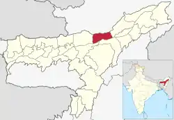
Biswanath (IPA: ˌbɪswəˈnɑːθ ˈtʃɑːrɪˌælɪ) is an administrative district in the state of Assam in India. It is one of newly created district in the year by 2015, declared by Assam Chief Minister Tarun Gogoi on 15 August 2015.[1][2] The district is created amalgamating Gohpur and most part of Biswanath Sub division on earlier Sonitpur district. The district is bounded by Arunachal Pradesh on north, Golaghat, Brahmaputra river on the south, Lakhimpur district on the east and Sonitpur district on the west. The administrative headquarter is located at Biswanath Chariali.
Biswanath District | |
|---|---|
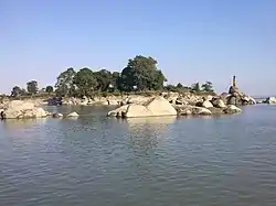 Biswanath ghat | |
 | |
| Country |  India India |
| State | Assam |
| Division | North Assam |
| Incorporated (District) | 15 August 2015 |
| Headquarter | Biswanath Chariali |
| Government | |
| • Lok Sabha constituencies | Tezpur |
| • Vidhan Sabha constituencies | Biswanath, Behali, Gohpur |
| Area | |
| • Total | 1,100 km2 (400 sq mi) |
| Elevation | 48−849 m (157−2,787 ft) |
| Population (2011) | |
| • Total | 612,491 |
| • Density | 560/km2 (1,400/sq mi) |
| Languages | |
| • Official | Assamese |
| Time zone | UTC+5:30 (IST) |
| Vehicle registration | AS-32 |
| Website | biswanath.gov.in |
History
The major part of Biswanath district formed a part of the Chutiya kingdom until it was annexed in the 16th century by the Ahoms. The western part of the district was under the rule of independent Bhuyan chieftains. The border between the Chutia kingdom and Bhuyan principalities were marked by the Dikarai [3] and the Ghiladhari rivers.[4] The Chutia kings built many forts in the region which included the Buroi fort (near Nyishi hills)[5] and the Pratapgarh fort built by king Pratap Narayan.[6][7]
Administration
- Headquarter
- Biswanath Chariali
- Name of Sub-Divisions
- Biswanath Chariali, Gohpur
- Name of Revenue Circles/ Tehsils
- Biswanath Chariali, Gohpur, Helem
- Name of Development(C.D.) Blocks
- Pub-Chaiduar Development Block
- Chaiduar Development Block
- Behali Development Block
- Baghmora Development Block
- Biswanath Development Block
- Sakomotha development Block
- Sotea Development Block
- Name of Police Stations
- Gohpur Police Station
- Helem Police Station
- Behali Police Station
- Ginjia Police Station
- Biswanath Chariali Police Station
- Sootea Police Station
- Hawajan Police Outpost
- Borgang Police Outpost
- Number of Villages
- 832
- Names of Towns
- Biswanath Chariali, Gohpur
- Name of Town Committees
- Biswanath Chariali, Gohpur
Demographics
According to the 2011 census, Biswanath district has a population of 612,491.[8]
As of the 2011 census, Hindus made up 514,259 which is 83.96% of the population. Muslims made up 52,155 and Christians 42,392 which is 8.52% and 6.92% of the population respectively.[8]
At the time of the 2011 census, 34.06% of the population speaks Assamese, 13.56% Sadri, 8.58% Bengali, 7.93% Nepali, 7.23% Boro, 7.09% Mising, 6.76% Odia, 3.41% Mundari, 2.56% Karbi and 1.84% Hindi as their first language.[9]
Railway Station
- Dubia
- Gohpur
- Brahmajan
- Helem
- Niz Borgang
- Monabari
- Viswanath Chariali
- Niz Sotea
References
- "CM Tarun Gogoi announces 5 new districts in Assam on Independence Day".
- "Assam gets five more districts". 15 August 2015.
- Baruah, Swarnalata. Comprehensive History of Assam,1986, p. 193.
- Neog, Maheswar. Early History of the Vaisnava Faith and Movement in Assam,1965, p. 66.
- Basu, Nagendra Nath. Thee Social History of Kamrupa,1988, p. 271.
- Bilgrami, Syaed Ali. Journal Of The Asiatic Society Of Bengal,1904, p. 258.
- The stone inscription found in Umatamani, Biswanath states that a king named Lakshminah was crowned as the Lord of Pratapapura(Pratapapura-adhikari Dalapati Shri Lakshminah). This was none other than the Chutia king Lakshminarayan
- (PDF). Ministry of Home Affairs, India. 2011 https://censusindia.gov.in/2011census/dchb/DCHB_A/18/1807_PART_A_DCHB_SONITPUR.pdf. Retrieved 2021-07-17. Missing or empty
|title=(help) - 2011 Census of India, Population By Mother Tongue