Cirque de Navacelles
The Cirque de Navacelles is large erosional landform, an incised meander, located towards the southern edge of the Massif Central mountain range in France. It is located near Saint-Maurice-Navacelles and Blandas between the Hérault department and the Gard department.[1]
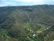
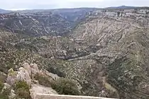
The cirque is isolated, with only a few small villages in the surrounding area. However, with the completion of the Millau Viaduct in 2004 and the A75 motorway between Clermont-Ferrand and Pézenas, tourism in the region has increased.
Fluvial processes in the cirque
The area is an example of a dissected plateau in which the Vis River eroded a deep channel through the base of the valley, creating an incised meander which eventually eroded through creating a cut-off at the neck of the loop.[2] This left an oxbow lake which later dried up, leaving deposits of silt and peat. This created what is the only patch of arable land for many miles around.
Road network
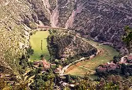
Roads in the area are very poorly maintained and are only wide enough for one vehicle. In order to pass the landform, a dangerous, but exhilarating, road which weaves down into the valley and clings to the sheer cliff face on the way back up must be braved. This journey is one of the draws for tourism in the area.
This whole section is subjective and entirely useless as a section on this subject. The road down from the Causses to the Cirque from the north/Blandas side is double-lane, has room for two maintenance trucks to pass with ease, and has a low wall along the side of the drop for the entirety of its route down. It opens out either side of the river and you can park and paddle in the river. The road on the south/St-Maurice-Navacelles side has been deliberately narrowed to reduce traffic and try to protect this special, historical site, but still has a wall on the side of the drop and passing places at regular intervals. The idea that anyone comes here to experience a “dangerous route” is absolutely absurd. People come to see its geographical, geological and historical importance, find out how it has been inhabited by humanity since ancient times, and marvel at its astonishing beauty and stunning views.
The paragraph about the "Road network" is the take of someone (I’m guessing an American), who’s rarely driven on rural roads in Europe, finds anything less than an eight-lane highway tricky to negotiate - ooh, corners! - and writes about everything as if it’s some kind of Tripadvisor tourist review, instead of as the marvellous site of special scientific interest that it actually is. They’ve created a bullshit subsection based on their own ignorance…
So here’s an idea, Wikipedia: how about asking someone to just translate the French page about this amazing place?
See also
Notes
- Official website: Geography of the cirque(in French)
- Official website: landscapes(in French)
External links
 Media related to Cirque de Navacelles at Wikimedia Commons
- Interactive map(in French)
- Cévennes Visitor Center website(in French)
- Personal website: photographs of the Cirque