Demir Hisar (town)
Demir Hisar (Macedonian: Демир Хисар [dɛˈmir‿xisar] ( listen)) Is a small town in North Macedonia. It is the seat of Demir Hisar Municipality. This small settlement has an absolute Macedonian ethnic majority. The name of the town translates to "Iron Castle" in Turkish, and dates back to the time when Macedonia was ruled by the Ottoman Empire.
Demir Hisar
| |
|---|---|
Town | |
.jpg.webp) | |
 Flag  Coat of arms | |
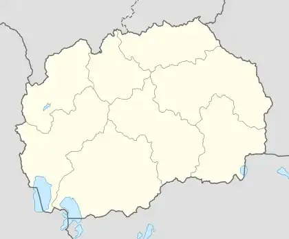  Demir Hisar Location within North Macedonia | |
| Coordinates: 41°13′15″N 21°12′11″E | |
| Country |  North Macedonia North Macedonia |
| Region |  Pelagonia Pelagonia |
| Municipality | Demir Hisar |
| Government | |
| • Mayor | Nikola Najdovski (VMRO-DPMNE)[1] |
| Population (2002) | |
| • Total | 2,593 |
| Time zone | UTC+1 (CET) |
| • Summer (DST) | UTC+2 (CEST) |
| Area code(s) | (+389) 047 |
| Car plates | DH |
| Climate | Cfb |
Etymology
Due to the richness of these mountains with iron ore, the area was named either Železnik or Železnec, depending on the ruler. This area is also known as "Demir Hisar" a name that the Ottoman Turks gave this area which means "Iron Mountain".
Region
The settlement is situated along the main road between the important Macedonian cities of Bitola and Kičevo. It is made up of smaller villages, including Barakovo.
Demographics
The Yugoslav census of 1953 recorded 902 people in Demir Hisar of whom 449 were Macedonians, 412 Turks, 27 Albanians and 14 others.[2] The 1961 Yugoslav census recorded 1129 people of whom 1047 were Macedonians, 39 Albanians, 24 Turks, and 19 others.[2] The 1971 Yugoslav census recorded 1828 people of whom 1731 were Macedonians, 34 Turks, 30 Albanians, 4 Romani, 1 Bosniak and 28 others.[2] The 1981 Yugoslav census recorded 2283 people of whom were 2145 Macedonians, 75 Albanians, 19 Turks, 17 Romani and 27 others.[2] The Macedonian census of 1994 recorded 2447 people of whom 2336 were Macedonians, 9 Albanians, 4 Turks and 98 others.[2]
According to the 2002 census, the town had a total of 2593 inhabitants.[3] Ethnic groups in the village include:[3]
- Macedonians 2,473 (95.37%)
- Albanians 62 (2.39%)
- Turks 22 (0.85%)
- Romani 11 (0.42%)
- Serbs 7 (0.27%)
- Vlachs 6 (0.23%)
- Bosniaks 2 (0.08%)
- Others 10 (0.39%)
History
Demir Hisar is a settlement west of the Pelagonia plain, on the main road from Bitola to Kicevo, i.e. the new road to Krusevo. It started to develop since 1945. Since its establishment as an urban settlement there has been a continuous increase in the population, which in 2002 included 2,593 inhabitants. In the municipality, there are 9,497 inhabitants in 41 settlements. Today Demir Hisar is an urbanized settlement of a city type, which has all the conditions for a small pleasant and arranged town.
Due to the richness of the mountains around this municipality with iron ore, the area was named Zeleznik or Zeleznec, which changed depending on the rulers at different times. This area is found as Sidero Kastron, which in Greek means Iron Fortress. Demir Hisar is the name that the Turks gave to this area that would mean Iron Fortress. That is the name that it has today.[4]
Gallery
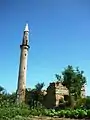 Old mosque of (Demir Hisar) [5]
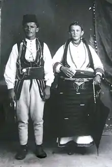 Couple of Demir Hisar, dressed in folklore costume, photographed in the studio of the brothers Manaki in Bitola, 1916
.jpg.webp) Council Seats House of Demir Hisar
Council Seats House of Demir Hisar.JPG.webp) Main road to Demir Hisar, 2010
Main road to Demir Hisar, 2010.JPG.webp) Streets in Demir Hisar, 2010
Streets in Demir Hisar, 2010
References
- Local Elections 2021 – Mayor of Demir Hisar. State Election Comission.
- Sherafedin Kaso (2005). The settlements with Muslim population in Macedonia. Logos-A. p. 74. ISBN 978-9989-58-155-7..
- Macedonian Census (2002), Book 5 - Total population according to the Ethnic Affiliation, Mother Tongue and Religion, The State Statistical Office, Skopje, 2002, p. 230.
- https://macedonia-timeless.com/eng/cities_and_regions/cities/demir-hisar/#:~:text=Demir%20Hisar%20is%20a%20settlement,in%202002%20included%202%2C593%20inhabitants.
- https://macedoniancities.com/history/demir_hisar.php
External links
 |
Wikimedia Commons has media related to Demir Hisar. |
Cities of North Macedonia by population | ||
|---|---|---|
| 50,000+ |  Coat of arms of North Macedonia | |
| 10,000+ | ||
| 2,000+ | ||
Authority control  | |
|---|---|
| General | |
| National libraries | |