Falleron (river)
The Falleron is a French coastal river forming the boundary between the departments of Vendée and Loire-Atlantique and flowing into the Bay of Biscay and Atlantic Ocean via the Bay of Bourgneuf.
| Falleron | |
|---|---|
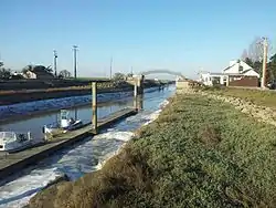 The Falleron at the port of Collet | |
| Native name | Falleron (French) |
| Location | |
| Country | France |
| Departments | Loire-Atlantique, Vendée |
| Physical characteristics | |
| Source | |
| • location | Grand'Landes |
| • coordinates | 46°51′18″N 01°39′04″W |
| • elevation | 60 m (200 ft) |
| Mouth | |
• location | Bay of Bourgneuf at Port du Collet |
• coordinates | 47°01′45″N 1°59′0″W |
| Length | 52 km (32 mi) |
Geography
It is 52 km long,[1] from its source at an altitude of 60 meters, in the town of Grand'Landes in the Vendée department. It flows into the Atlantic Ocean at the port of Collet in the Bay of Bourgneuf. It is the main emissary of the Marais Breton.
Hydrography
The main tributaries of the Falleron are all located on the left bank, from upstream to downstream:
- ru de la Gautrelière;
- ru du Marchais;
- ru de la Blanchardière;
- Dain canal.
At its opening in the Marais Breton, the Falleron is divided into numerous tidal creeks and canals, the most important being:
- l'étier de la Taillée;
- l'étier du Chiron Boileau;
- l'étier de la Gravelle.
Communes crossed
The Falleron crosses or constitutes the limit of the following municipalities:
- Grand'Landes (Vendée);
- Falleron (Vendée) and Touvois (Loire-Atlantique);
- Froidfond, La Garnache (Vendée) and Saint-Étienne-de-Mer-Morte (Loire-Atlantique);
- Paulx (Loire-Atlantique);
- Machecoul (Loire-Atlantique);
- Bois-de-Céné (Vendée) and Bourgneuf-en-Retz (Loire-Atlantique);
- Bouin (Vendée) and Les Moutiers-en-Retz (Loire-Atlantique).

Notes and references
- Sandre. "Fiche cours d'eau - Le Falleron (N01-0300)". Retrieved 23 May 2014.
This article is issued from Wikipedia. The text is licensed under Creative Commons - Attribution - Sharealike. Additional terms may apply for the media files.