Forest Hall
Forest Hall is an area in the borough of North Tyneside in the United Kingdom. Named after a long gone palatial residence, it is a north eastern suburb of Newcastle and lies six kilometres from the city centre. Until the 1960s it was a sleepy village with a railway station on the main line from London to Edinburgh.[1] While relatively affluent compared to some surrounding areas, its proximity to Killingworth has led to an increase in antisocial behaviour in recent years.[2] For local government, most of the area is in Benton ward,[3] while some residential streets towards the north and the east are in Killingworth ward.[4] In the 1890s the area was home to the Clousden Hill Free Communist and Co-operative Colony.[5]
| Forest Hall | |
|---|---|
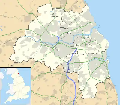  Forest Hall Location within Tyne and Wear | |
| OS grid reference | NZ269683 |
| Metropolitan borough | |
| Metropolitan county | |
| Region | |
| Country | England |
| Sovereign state | United Kingdom |
| Post town | NEWCASTLE UPON TYNE |
| Postcode district | NE12 |
| Dialling code | 0191 |
| Police | Northumbria |
| Fire | Tyne and Wear |
| Ambulance | North East |
| UK Parliament | |
Facilities and Transport
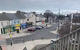
The area is centred around Station Road, a compact shopping street with a variety of shops, takeaway food outlets and restaurants, two small supermarkets, a pharmacy and an optician. Scattered around are pubs and social clubs such as Forest Hall Ex-Servicemen's Institute and the Clousden Hill. Additionally, Springfield Park, a somewhat sizeable public park, is located near Station Road; it has sports grounds, a playground and a community centre.[6]
Churches
- St Bartholomew's - Church of England[7]
- St Andrew's - Methodist
- St Mary's - Roman Catholic[8]
- Westmoor Methodist Church[9]
- Bethesda Gospel Hall[10]
There are no non-Christian places of worship in the area; the nearest synagogue is in Gosforth[11] and the nearest mosque is in Heaton.[12]
Several bus routes pass through Forest Hall, linking it to both Newcastle city centre and other surrounding areas. The number 55 bus takes twenty minutes to travel to the Haymarket,[13] while the 63 takes thirty to the Monument.[14] Although the East Coast Main Line runs directly through the village centre there are no rail links, nor have there been since September 1958;[1] however, Benton station on the Tyne & Wear Metro is located less than a kilometre away. The former site of Forest Hall railway station is now occupied by the Flying Scotsman pub,[15] named after the famous railway service.
Education
Primary Schools
- Forest Hall Primary School[16]
- St Mary's Roman Catholic Primary School[17]
- Ivy Road Primary School[18]
- Westmoor Primary School[19]
There are no secondary schools within Forest Hall, but George Stephenson High School[20] in Killingworth and Longbenton High School[21] are both nearby. The nearest sixth forms and universities are in Newcastle city centre.
Dial Cottage
Dial Cottage, a grade II listed building[22] and home from 1804 to 1823 of railway pioneer George Stephenson,[23] is located on Great Lime Road in Forest Hall. It was while he was living there that Stephenson developed one of the world's earliest locomotives, called the Blücher, as well as several others which ran on the Killingworth Colliery from 1814. The trackbed is now a public footpath which can be accessed from Great Lime Road a kilometre east of the cottage.
The cottage is privately owned, though tours occasionally take place. At the cottage there is a sundial, which Stephenson built himself and which gives the cottage its name, and a plaque which reads:
“George Stephenson. Engineer, inventor of the Locomotive Engine. Lived in this cottage from 1805 to 1823; his first locomotive (Blücher) was built at the adjacent colliery wagon shops, and on July 25, 1814 was placed on the wagonway which crosses the road at the east end of this cottage."[24]
Notes
- "Disused Stations: Forest Hall Station (NER)". Disused Stations. Retrieved 5 March 2021.
- "Council seeks to reassure residents following reports of antisocial behaviour in Killingworth and Forest Hall". North Tyneside Council. 25 April 2019. Retrieved 4 March 2021.
- "Benton Ward". North Tyneside Council. Retrieved 5 March 2021.
- "Killingworth Ward". North Tyneside Council. Retrieved 5 March 2021.
- Henderson, Tony (16 December 2015). "How Clousden Hill communist agricultural colony in Newcastle sought to change the world". ChronicleLive. Retrieved 15 March 2021.
- "Springfield Community Centre". Springfield Community Association. Retrieved 4 March 2021.
- "St Bartholomew's Church". Retrieved 4 March 2021.
- "St Mary's Church". Diocese of Hexham and Newcastle. Retrieved 4 March 2021.
- "Newcastle Methodist Churches". Newcastle Central + East Circuit. Retrieved 4 March 2021.
- "Bethesda Gospel Hall". Retrieved 4 March 2021.
- "United Hebrew Congregation Newcastle". Retrieved 4 March 2021.
- "Heaton Mosque". Retrieved 4 March 2021.
- "55 Bus Timetable". Arriva Bus. Retrieved 4 March 2021.
- "63 Bus Timetable". Stagecoach. Retrieved 4 March 2021.
- "Flying Scotsman". Retrieved 4 March 2021.
- "Forest Hall Primary School". Retrieved 4 March 2021.
- "St Mary's RC Primary School". Retrieved 4 March 2021.
- "Ivy Road Primary School". Retrieved 4 March 2021.
- "Westmoor Primary School". Retrieved 4 March 2021.
- "George Stephenson High School". Retrieved 4 March 2021.
- "Longbenton High School". Retrieved 4 March 2021.
- "Dial Cottage, a grade II listed building". British Listed Buildings. Retrieved 4 March 2021.
- "George Stephenson's Birthplace". National Trust. Retrieved 4 March 2021.
- "Geograph:: Plaque and sundial, Dial Cottage, West... © Graham Robson cc-by-sa/2.0".
External links
 Media related to Forest Hall at Wikimedia Commons