Y Garn Goch
Y Garn Goch is a hill in the Brecon Beacons National Park in the east of Carmarthenshire, Wales. The name means the 'red cairn'. It lies near the village of Bethlehem, three miles southwest of Llangadog and four miles east of Llandeilo on the southern side of the broad Towy Valley. It is also commonly known as either Garn Goch or Carn Goch. Current owners and land managers are the Brecon Beacons National Park Authority.[1]
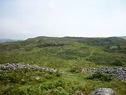
Geology
Y Garn Goch is formed from the coarse sandstones of the Ffairfach Grit Formation of the early Ordovician period. A northeast-southwest oriented anticline (the Garn Goch Anticline) which runs through Y Garn Goch can be seen to fold these rocks. The sandstones and mudstones of the Abergwilli (sic)[2] and Llandeilo Flags formations form the lower slopes of the hill to north and south. A fault runs northeast-southwest through the saddle between the two tops and is considered a part of the Welsh Borderland Fault System.
The lower ground is mantled by glacial till, a legacy of the last ice age when the valley was filled by the Towy Valley glacier. The hill lies within Fforest Fawr Geopark designated in respect of the outstanding geological heritage of the region.[3][4]
Archaeology
The established view is that Y Garn Goch is notable for the two impressive Iron Age hillforts of Y Gaer Fawr, (English: the big fort) and Y Gaer Fach, (English: the little fort), together the largest in southern Wales, but just as it has taken almost 100 years for Waun Mawn to be recognised as a significant and unique Neolithic monument, the 'original' Stonehenge,[5] it has taken almost 50 years for the view to be challenged that Garn Goch is not merely one of almost 700 Iron Age forts in Wales,[6] but rather a significant and unique, primarily religious Neolithic monument.
An Iron Age Fort?
In Iron Age Wales they built three types of fort: promontory forts using coastal cliffs to protect three sides of the fort (more accurately described as defended enclosures);[7] earthworks forts on the top of steep sided hills with concentric rings of defensive ditches and banks;[8] large stone forts including revetted walls typically 3 metres high by 2 metres wide, and always with ramparts on top.[9] Garn Goch fits into none of these categories, yet the received view has been that Garn Goch is one (or two) of the many Iron Age hillforts in Wales, so is far from being either unique or significant.
A. H. A. Hogg and the Iron Age Fort Article
This interpretation derives from a brief report[10] in Archaeologica Cambrensis nearly 50 years ago[11] by A. H. A. Hogg, then at the end of a long career[12] that resulted in him being regarded as the foremost authority on Welsh Iron Age hillforts.[13] He says he will undertake no excavation, and concentrate on 'detailed factual descriptions',[11] yet then admits his descriptions are 'only rough'.[11] With impressive honesty, he admits to features being 'puzzling', and uses phrases like 'The writer inclines to the view that...' as well as admitting to there being several 'anomalies'.[11] The verifiability of some of his statements can be called into question. Specifically:
1. He assumed, so neither questioned nor proved, that Garn Goch was a 'fort', yet Tre'r Ceiri, where his ongoing excavations had made his reputation decades before, has 'a formidable single rampart which still stands up to 4m high in places. Where nearly intact, the top of the rampart still has its parapet walk reached via a number of sloping ramps from the interior.'[14] Here is what the ramparts of the nearby Garn Boduan Iron Age hillfort look like. Garn Goch has none of those features, and simple observation of the number of stones, and the absence of any evidence of revetted walls, argues compellingly that it never had them, so they cannot be, as Hogg describes them, 'very ruinous'.[11]
2. Tre'r Ceiri had 8 posterns, and Hogg stated that Garn Goch has 6 posterns (and Coflein copies this),[14] which he described as 'ruinous',[11] yet are more accurately described as imaginary. Here is what a postern at Tre'r Ceiri looks like. In fact, there is only one that could be described as a postern ('a secondary door or gate in a fortification...often located in a concealed location which allowed the occupants to come and go inconspicuously').[15] It's on the south side, is not at all concealed, and there are no signs of gate posts, nor holes for gates hinges,[16] so was not part of defensive arrangements. As importantly, he argues that the wide entrances east and west are a 'double portal' and 'gateway', although he admits there is no evidence, and that 'proof is impossible',[17] yet such wide entrances are entirely inconsistent with a fort, and entirely consistent with a Neolithic causewayed enclosure, especially as there are entrances north, south, east and west.[18]
3. He admitted he could not date anything on Garn Goch with any confidence, and openly stated that there are 'very tenuous features',[19]
4. He focused on foundations which he hazarded might be Iron Age, Neolithic or, he said, may be mediaeval.[20]
5. He concluded that some central foundations are of a round house, yet only a moment's observation shows that they lie about a metre below the level of the post-glacial pond,[21] now bog, and they are where the stream began to run down the hillside. It is an elongated oval, not round at all, and makes much more sense as a pool for ceremonial baptisms or votive offerings.
6. He dismissively describes the main long cairn as 'a mass of rubble' and 'completely ruinous' because it shows 'no trace of revetment',[22] and that lays clear his lack of knowledge and interest in anything that does not have Iron Age revetted walls, ramparts and posterns. His unhelpful conclusion is that it is 'anomalous'[23] (his word), yet it is only 'anomalous' if it's an Iron Age fort, although Tre'r Ceiri also has a large cairn within its Iron Age fort walls. At a religious site, a large cairn is the very opposite of 'anomalous'. He guesses the cairn must be Neolithic or Bronze Age,[24] again showing his ignorance about funerary practices outside the Iron Age.
7. He said 'there are short lines of small boulders deliberately placed', but then said they don't 'fall into any defined pattern', so left them 'unsurveyed'.[25] If there was one thing to be properly surveyed, surely it was the 'walls'? Observation shows the stones were anything but 'deliberately placed', and as to 'short lines' they run for 1.7 kms.[26]
8. Of four metre long, 0.8m high mounds, he suggested they were 'intended to encourage the growth of rabbits'.[27] A conclusion needing no further comment.
9. He concluded that it is 'unlikely' the two forts were 'occupied at the same time',[28] but, somehow, thought they were also 'roughly contemporary'.[29]
One example of how the Hogg interpretation has continued to be perpetuated is the Archwilio entry for Garn Goch[30] which repeats three of Hogg's points before valiantly talking of 'gateways', six 'posterns' (her speech marks) when there is evidence of only one, medieval foundations when there is absolutely no evidence they are medieval, and 'ramparts' when there is absolutely no evidence that there was anything more, even at the western ends, than piled stones. On the contrary, it would be reasonable to argue that Garn Goch was never more than an Iron Age folly with its height enhanced western walls intended to scare off invaders coming up the Tywi valley.
Other, non-archaeological authorities have also continued to repeat Hogg's opinion without questioning it, or, it might be suggested, even reading the original report.[31] However, it must also be said that if Garn Goch was merely one of almost 700 Welsh Iron Age hillforts, then it is perfectly understandable that it has received scant attention from publicly funded heritage and archaeological organisations, and admirable that Brecon Beacons National Park, its current managers, have done their best to promote it as such.
The Age Of Monuments
The Neolithic farmers who arrived in Britain 6,000 years ago[32] tended to be highly religious, worshipping their ancestors out of respect, but also in the hope (expectation) that if they did right by them, then their ancestors would help to cause good weather, bumper harvests, and a productive family life. At equinoxes and solstices, they attended large scale gatherings for religious ceremonies, social interaction, and communal monument building over several days, or perhaps weeks.
Using comparatively large numbers of largely unskilled labour, these monuments could be impressive in scale, but also had to be simple in design and execution - Stonehenge is the exception, not the rule. A large long barrow might need 10,000 man-hours, but that is 'only' 250 people working for 7 days on each of 6 visits (say, three times a year over two years). That seems achievable and realistic, but it is reckoned that Silbury Hill would have taken 18 million man-hours, and Stonehenge 30 million,[33] so that all required serious religious dedication, conceptual planning, logistical organisation, and sophisticated people management.
There are three defining factors of Neolithic monument building: religious motivation, communal execution, and bigness. There are also three things they didn't do: build defences, build buildings, build complexly (with one major exception). Over roughly 1,500 years (so equivalent to when the Romans left Britain to the First World War), they built oval mortuary enclosures (typically 50 by 20 metres, often with long barrows or cairns inside them),[34] ring cairns (15 in south Wales.[35] Typically 8 to 20 metres in diameter,[36] and located next to water), stone and timber circles (at Walton in Powys, a massive timber palisaded enclosure was 800 metres in diameter.[37] At Durrington Walls, there are 98 massive upright sarsen stones underground with earthworks and timber palisades subsequently built on top),[38] and cursuses (the Dorset Cursus runs for six miles).[39]
Even more relevantly to Garn Goch, they built:
Causewayed Enclosures: built on easily accessible, flat hill tops, oval or circular earthworks typically 200+ metres in diameter with spectator banks surrounded by religiously significant ditches (delineating life from death), and featuring wide tracks (causeways) leading to four large entrances.[40] They can be thought of as being like sports stadia, not least because nobody lived in them.
Henges: evolved out of causewayed enclosures, and then into massive super-henges like Durrington Walls, Avebury and Mount Pleasant, which have diameters of up to 480 metres (the width of seven football pitches).[41]
Long Barrows & Long Cairns: long barrows (earth) and long cairns (stones) typically up to 300 feet long with a burial chamber inside. Garn Goch is a westerly example of the chain of Neolithic long cairns that include Penywyrlod near Talgarth and Ty Isaf in Wales, and the numerous long cairns in the Cotswold-Severn group centred on Hazleton.[42]
Their crowning glory was, of course, Stonehenge, but it is an outlier that disproves the rule. It was constructed in several stages over several centuries, and is complex in design and execution, whereas other Neolithic monuments were simple in design, constructed at one time albeit over several years, used, then abandoned.
While Garn Goch exhibits few, if any, characteristics of an Iron Age fort, it shares many characteristics with many of these Neolithic monuments, not least long cairns, causewayed enclosures (the most obvious design origin), henges and super-henges (it as large as them).[43] In the context of Parker Pearson and his team's work at Waun Mawn, Garn Goch can be seen not as an outlier, but directly on the ridgeways 'camino' from the more heavily populated south east[44] to the major early Neolithic religious sites at, and around, Waun Mawn, and also having religious and social, not military, significance.
If Not Walls, Then...
If they are not collapsed Iron Age defensive walls, then why are they there, and who put them there? Neolithics associated timber with life, stone with death, so laying 'ancestor stones' was venerating their ancestors, and defining the boundaries of that sacred space, each stone making it more sacred, more powerful. They weren't building fortifications to keep others out, rather delineating a powerful space for them to pray within. So, the stones of Garn Goch belong to the ancient tradition of cairn building: they are religious landmarking of boundaries, and are most accurately described as linear cairns, or, perhaps even better, as one continuous linear cairn, albeit disrupted by entrances. Like other Neolithic monuments (stone circles, standing stones, henges), they represent a much more simple, more natural approach to religion and religious experience.
Dating Garn Goch
Non-military, large scale earth and stone monument building was a defining Neolithic characteristic, so we can date such monuments to between 6,000 and 4,500 years ago,[45] but we can be more precise about Garn Goch. With irrefutable evidence from the Penywyrlod long cairn, we can say with confidence that farmers were migrating to this region to open up new farmland about 5,700 years ago, give or take up to 70 years.[46] As the Penywyrlod long cairn is part of a group of long cairns linked to the Cotswold-Severn group centred on Hazleton,[42] and Garn Goch's long cairn is similar, it is reasonable to propose that Garn Goch is one of the most westerly of this group of Neolithic long cairns.
Consequently, we can confidently date the Garn Goch long cairn to around 5,700 years ago, or perhaps 100 or so years later. We also know that from about 5,000 years ago, the Neolithic era was dominated by a major decline of farming,[47] and a rise in plague pandemics.[48] Given that people starving and/or being killed by plague tend not to build large monuments, we can confidently date Garn Goch, albeit making various informed assumptions, to 5,700 to 5,600 years ago, and the linear cairn assembly period to between 5,600 and 5,000 years ago, but perhaps continuing closer to 4,500 years ago.
Garn Goch, then, is older than Stonehenge,[49] but only archaeological excavations and technology based analyses will definitively prove whether that is roughly right - or wholly wrong. Why Garn Goch has not been archaeologically excavated when English long cairns and Penywyrlod in the same group have been since the 1970s is something only Dyfed Archaeological Trust and Cadw can explain.
The Scale Of Garn Goch
Garn Goch must be big for the simple reason that it needed to be. You don't build Wembley Stadium for a maximum crowd of 10,000, or the whole Glastonbury Festival site for a few hundred festival goers. So how many Neolithic ‘Brits’ went to Garn Goch 'festivals'?
If we accept the estimate of the UK Neolithic population as at least 250,000,[50] and that 1 in 5 of them were geographically close enough to consider attending Garn Goch at summer solstice, that’s 50,000 people. Given various rivalries, travel difficulties and communication limitations, it might be that of those 50,000, 1 in 5 actually attended,[51] so there would have been 10,000. 1 in 10 is still 5,000. A site the size of Garn Goch with 5,000 to 10,000 people makes sense as the site had to be large enough for many thousands of people over several days or even weeks. Equally, for 500 to 1,000 people it makes no sense.
To attract such numbers, Garn Goch must have been a major Britain-wide pilgrimage destination for at least one of its annual events, and that should be seen in the context of Professor Parker Pearson's statement that there is 'no doubt that [Pembrokeshire] was one of the great religious and political centres of Neolithic Britain'.[52] Rather than being an outlier, this places Garn Goch directly on the ridgeway 'camino' from the populous south of England to Pembrokeshire, so a destination in its own right as well as a stopover.
Its decline in popularity could have been caused by either or both the rise of Stonehenge as the primary Neolithic pilgrimage site, and the decline in farming accompanied by pandemic plagues as noted above.
The largest ancient stone monument in Britain
This is an unexpected, formidable, and, at first sight, unlikely claim for an insignificant, rarely visited site in Carmarthenshire, but research provides compelling justification:
Largest: Maiden Castle is the largest Iron Age fort in England,[53] but Garn Goch's acreage is almost the same, and its central area more than twice that of Maiden Castle's central area.[54] Caerau was said by Channel Four's Time Team to be the largest in Wales,[55] yet according to Coflein its area is 5 hectares[14] whereas Garn Goch with its northern spur is almost 19 hectares.[56] The four super-henges are comparable in size, but are, like the two forts above, earthworks.[57] Garn Goch, though, isn't an Iron Age fort, those are earthworks, forts are not monuments (see below), and there are no other Neolithic monuments that have a larger area enclosed by stone.
However, Garn Goch is not Britain's greatest ancient stone monument, nor its most significant, nor its most important. That must be Stonehenge, which is much 'greater', but isn't larger.
Ancient: better than 'remote past', the most precise definition of ancient is before the emergence of writing,[58] and therefore before written history. Literally, then, pre-historic, so the Bronze Age, Ancient Greece and Ancient Egypt are not, strictly, prehistoric/ancient. Neolithic, on the other hand, is indisputably prehistoric, so indisputably 'ancient', and the origins of Garn Goch's long cairn are indisputably Neolithic.
Stone: there are longer ancient earthworks, such as cursuses running for miles, but we're only talking about stone monuments in Britain (so Carnac's lines of erect stones that run for kilometres and kilometres don't count).
Monument: Oxford Dictionaries' three definitions[59] are: a) a statue, building, or other structure erected to commemorate a notable person or event; b) a statue or other structure placed over a grave in memory of the dead; c) a building, structure, or site that is of historical importance or interest. On all three definitions, then, Garn Goch, or at least the long cairn, is a bona fide monument, whereas Iron Age forts, for example, only qualify on the third of those definitions.
In fact, that definition excludes very large stone constructions like the stone-based reconstructed 2nd century AD Hadrian's Wall (except on the third of those grounds), and even monuments like St Paul's Cathedral and Wembley Stadium don't cover a greater area than Garn Goch,[60] but, then again, none of those are ancient.
Garn Goch Tomorrow
It is important that Garn Goch is academically examined, technologically explored, and archaeologically excavated just as it is important that the nearby village of Bethlehem is both protected and, potentially, evolved as the Gateway to Garn Goch. A Community Interest Company, Garn Goch CIC, has been created, and is Limited By Guarantee, so all excess income will be distributed to local good causes, and the directors cannot be paid any dividends.
A website has been created - garngoch.org - with much more information, and where guided visits can be booked. For the 'full story', a 150 page book will be able to be bought via the website: 'A Pile Of Old Stones: How Wales Made Then Forgot The Largest Ancient Stone Monument In Britain' by Martin Price.
Access
The entire hill is registered common land and hence freely available to walkers as access land. It is approached by minor cul-de-sac roads from east and west and a public footpath runs north-south across it. The Beacons Way which starts at Llangadog passes through the nearby village of Bethlehem before running west-east over the hill en route for the Black Mountain (Welsh: Y Mynydd Du) and eventually Abergavenny.
See also
References
- Ordnance Survey Explorer map OL12 'Brecon Beacons National Park: western area'
- "Abergwilli Formation". BGS Lexicon of Named Rock Units. British Geological Survey. Retrieved 4 July 2021.
- British Geological Survey 1:50,000 map sheet 212 'Llandovery' & accompanying sheet explanation
- Gaer Fawr, Hillfort on Y Garn Goch
- In 1923 the geologist H.H. Thomas speculated that the Stonehenge bluestones had initially been incorporated into a 'venerated stone circle' somewhere in the Preseli hills. [HH Thomas, The Source Of The Stones Of Stonehenge, Antiquaries, Journal 3, 1923, p.258.] Two years later, Waun Mawn was first identified as its possible location, (An Inventory of the Ancient Monuments in Wales and Monmouthshire. Volume VII. County of Pembroke. RCAHMW (The Royal Commission on the Ancient and Historical Monuments and Constructions in Wales and Monmouthshire), HMSO, London, 1925.) yet it took until 2006 for geological analysis to confirm it, (O Williams-Thorpe et al, Preseli dolerite bluestones: axe-heads, Stonehenge monoliths, and outcrop sources, Oxford Journal of Archaeology, 25, 2006, pp. 29–46.) and until 2020 for there to be sufficient excavation evidence to convince the BBC to produce the prime time programme broadcast in February 2021 featuring Dr Alice Roberts and Professor Mike Parker Pearson. (Stonehenge: The Lost Circle Revealed. First broadcast 12 February 2021: https://www.bbc.co.uk/programmes/m000s5xm).
- In 1979, AHA Hogg said there were 3,300 hillforts and defended enclosures (A. Hogg. 'British Hill-forts: An Index',(Oxford, 1979), p.62.) whereas an authoritative 5 year survey published in 2018 by Oxford University (G Lock & I Ralston, 2017: https://hillforts.arch.ox.ac.uk) says there are 4,147 hillforts, many of which are in Scotland and its borders, but Wales has 687, a disproportionately large number for its size.
- 2 out of 3 Iron Age forts in Pembrokeshire are coastal promontory forts. Use the map at https://hillforts.arch.ox.ac.uk to close in on coastal forts to see how ubiquitous they are on the coasts of Britain, and particularly Wales.
- "ArcGIS Web Application". hillforts.arch.ox.ac.uk. Retrieved 2021-07-30.
- Two of the best examples of large stone forts in Wales are Garn Boduan <https://coflein.gov.uk/en/site/95271?term=Garn%20Boduan> and Tre'r Ceiri <https://coflein.gov.uk/en/site/95292?term=Tre%27r%20Ceiri>
- 11 pages when, for example, the preceding article on Rhos-y-Clegyrn Prehistoric Site runs to 30 pages, and the next article on the north east gate of Segontium runs to 24 pages.
- "Archaeologia Cambrensis (1900-1999) | Vol. 123 | 1974 | Welsh Journals - The National Library of Wales". journals.library.wales. Retrieved 2021-07-29.
- His first publication was in 1930.
- "Library". archaeologydataservice.ac.uk. Retrieved 2021-07-29.
- "English". Coflein. Retrieved 2021-07-30.
- The Wikipedia definition is far better than any other, so quoted here.
- As he himself admits: Hogg, Archaeologica Cambrensis, 1974, p.51.
- Hogg, Archaeologica Cambrensis, 1974, p.51.
- Causewayed enclosures were typically built by 'regularly scheduled large-scale aggregations of people'[20] on easily accessible, flat hill tops. They were oval or round, often about 200 metres in diameter, and made with an earth bank surrounded by a series of ditches, but, crucially, they had four causeways, or tracks, straight through them, confirming that they had a religious rather than military purpose.A. Whittle et al, Gathering Time: Dating The Early Neolithic Enclosures Of Southern Britain, (Oxbow Books, 2011), Abstract. http://orca.cf.ac.uk/32256/
- Hogg, Archaeologica Cambrensis, 1974, p.45.
- Hogg, Archaeologica Cambrensis, 1974, p.46.
- A 40m by 15m pond as recently as 1906. Hogg, Archaeologica Cambrensis, 1974, p.48.
- Hogg, Archaeologica Cambrensis, 1974, p.44.
- Hogg, Archaeologica Cambrensis, 1974, p.44.
- Hogg, Archaeologica Cambrensis, 1974, p.44.
- Hogg, Archaeologica Cambrensis, 1974, p.45.
- Google Maps measurement tool.
- Hogg, Archaeologica Cambrensis, 1974, p.45.
- Hogg, Archaeologica Cambrensis, 1974, p.53.
- Hogg, Archaeologica Cambrensis, 1974, p.53.
- "DAT887". www.archwilio.org.uk. Retrieved 2021-07-30.
- Three varied examples: 'The remains of two hillforts probably dating to the Iron Age period', Cadw. http://cadwpublic-api.azurewebsites.net/reports/sam/FullReport?lang=en&id=2757 'Best regarded as a later Prehistoric type hillfort', Coflein. https://coflein.gov.uk/en/site/100866/ 'The biggest hill fort in South East Wales', The modern Antiquarian. https://www.themodernantiquarian.com/site/2103/carn_goch_hill_fort.html
- Brace, S. (15 April 2019). "Ancient genomes indicate population replacement in Early Neolithic Britain". Nature Ecology & Evolution: 1–19 – via JSTOR.
- Startin, B. (1981). "Some Notes On Work Organization And Society In Pre-historic Wessex". British Archaeological Reports.
- Buckley, D (1988). "Excavation of a Possible Neolithic....Mortuary Enclosure at Rivenhall, Essex". Proceedings of the Prehistoric Society. 54 – via JSTOR.
- AH Ward, Survey and Excavation of Ring Cairns in SE Dyfed and on Gower, West Glamorgan, Proceedings of the Prehistoric Society, Volume 54, 1988, pp.153-172. 'A stony ring enclosing an open central area...[featuring] tumbled stones...on ridges dominated by higher ground...an E-W axis...built for public performance of ceremonial [with] suitability for arenas...connected with mortuary ritual...[but also with] wider social and economic... use'. Ward, Ring Cairns, 1988, p.153.
- Ward, 'Ring Cairns', 1988, p. 160. Also F. Lynch, 'Ring Cairns In Britain & Ireland', Ulster Journal Of Archaeology(volume 42, 1979), p.2.
- "The Neolithic Palisaded Enclosure at Hindwell, Powys, Wales | Journal of Neolithic Archaeology". www.jna.uni-kiel.de. Retrieved 2021-07-30.
- "Massive stones found buried in super henge near Stonehenge". Physics Today. 2015-09-08. doi:10.1063/PT.5.029183.
- https://www.megalithic.co.uk/article.php?sid=1377 Megalithic website
- Harding, J (1995). "Social Histories and Regional Perspectives in the Neolithic of Lowland England". Proceedings of the Prehistoric Society. 61: 117–136. doi:10.1017/S0079497X00003054 – via JSTOR.
- Durrington Walls is one of the largest known henges with a diameter of nearly 480 metres. https://physicstoday.scitation.org/do/10.1063/PT.5.029183/full/
- Saville, A (2013). "Hazleton North: The excavations of a Neolithic long cairn of the Cotswold Severn Group". English Heritage. 13.
- A 480 metre diameter results in 18 hectare area, and Garn Goch with its northern extension is about 19 hectares.
- Bevan, A (December 2017). "Holocene Fluctuations In Human Population Demonstrate Repeated Links To Food Production And Climate". PNAS. 114 (49): E10524–E10531. doi:10.1073/pnas.1709190114. PMC 5724262. PMID 29158411.
- Abrupt climate changes resulted in 'boom-and-bust' Neolithic populations. The more favourable the climate, the larger the population. S Downey et al, 'European Neolithic Societies Showed Early Warning Signals of Population Collapse.' Proceedings of the National Academy of Sciences of the United States of America, vol. 113, no. 35, 2016. [47] A Timpson et al, Reconstructing regional population fluctuations in the European Neolithic using radiocarbon dates: a new case-study using an improved method, Journal of Archaeological Science, Volume 52, December 2014.
- 'Radiocarbon...suggests that agriculture first began to develop in this region...between [5,765 and 5,655 years ago with a] 95% probability', and that the teeth of some of the first Neolithic farmers, who were brought up in Brittany and buried in Talgarth, date similarly - 5,770 to 5,630 years ago. The authors of the journal article assume the contemporaneity of the cairn and the teeth, which would date the cairn to about 5,700 years ago. S. Neil et al, 'Land use and mobility during the Neolithic in Wales explored using isotope analysis of tooth enamel ', American Journal of Physical Anthropology (July 2017). https://onlinelibrary.wiley.com/doi/full/10.1002/ajpa.23279
- S. Downey et al, 'European Neolithic societies showed early warning signals of population collapse', PNAS (volume 113, No. 35, August 30, 2016), p. 9751. C. Stevens et al, 'Alternative strategies to agriculture: the evidence for climatic shocks and cereal declines during the British Neolithic and Bronze Age (a reply to Bishop)', World Archaeology, (volume 47, issue 5, 2015).
- Rascovan, N (January 2019). "Emergence and Spread of Basal Lineages of Yersinia pestis during the Neolithic Decline". Cell. 176 (1–2): 295–305.e10. doi:10.1016/j.cell.2018.11.005. PMID 30528431. S2CID 54447284 – via JSTOR.
- The central construction we call Stonehenge was built less than 5,000 years ago.
- In the Neolithic, it varied from 250,000 to 500,000. Zimmerman's exhaustive analysis of population densities in the Rhineland provides a model for other regions. His team's conclusion is that there was a population density of 0.6 people per square kilometre (p/km) 7,000 years ago in the Rhineland.[A. Zimmermann et al, 'Estimations of Population Density for Selected Periods Between the Neolithic and AD 1800', Human Biology (volume 81, Issue 2, 2009, p.375] Taking the whole of the British landmass (242,500 square kilometres) the Mesolithic population of Britain would have been roughly 150,000. The population of England and Wales rose rapidly after 6,000 years ago', [S. Shennan, 'Evolutionary Demography and the Population History of the European Early Neolithic.” Human Biology(vol. 81, no. 2/3, 2009), p. 344.] rising to a population density of perhaps 2 p/km - about 500,000 at its peak - but it fluctuated by up to 60%, and declined significantly towards the end of the era to, perhaps, 250,000.
- In 2019, around 220 million people went to Prayagraj for the 50-day Hindu festival Kumbh Mela – the world’s largest human gathering. As Hindus are 80% of India’s population of 1.07bn that 220 million means roughly 1 in 5 Hindus attended that event (assuming only Indian Hindus attended).
- p.14
- https://www.english-heritage.org.uk/visit/places/maiden-castle/history/
- Maiden Castle covers 47 acres (19 ha), but its central enclosed area is much less than half that. Garn Goch is about 19ha including its northern spur, so it is the same size as Maiden Castle, but its enclosed area is roughly twice that of Maiden Castle.
- Source now unavailable online.
- Google measurement tool. Coflein seriously understates its area.
- The largest has a 480 metre diameter so a 18 ha area, and Garn Goch with its northern extension is about 19 ha.
- 'Scholars generally agree that the earliest form of writing appeared almost 5,500 years ago in Mesopotamia'. British Library. [https://www.bl.uk/history-of-writing/articles/where-did-writing-begin#]{{dead link|date=November 2021}}
- "MONUMENT | Definition of MONUMENT by Oxford Dictionary on Lexico.com also meaning of MONUMENT". Lexico Dictionaries | English. Retrieved 2021-07-30.
- St Paul's: 157 x 69 metres. Wembley Stadium has a circumference of 1km (Presspack: Facts and Figures. Wembley National Stadium Limited. 17.3.07), and Garn Goch 1.7km.