Gaya Airport
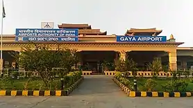
Gaya Airport, also known as Bodhgaya Airport, (IATA: GAY, ICAO: VEGY) is an international airport serving Gaya, Bihar, India. This airport is 12 kilometres south-west of Gaya and 5 kilometres away from the temple city of Bodhgaya which is Gautama Buddha's place of enlightenment.
Gaya Airport Bodhgaya Airport | |||||||||||
|---|---|---|---|---|---|---|---|---|---|---|---|
 | |||||||||||
| Summary | |||||||||||
| Airport type | Public | ||||||||||
| Operator | Airports Authority of India | ||||||||||
| Serves | Gaya | ||||||||||
| Location | Gaya, Bihar, India | ||||||||||
| Opened | 1936 | ||||||||||
| Elevation AMSL | 116 m / 380 ft | ||||||||||
| Coordinates | 24°44′40″N 084°57′04″E | ||||||||||
| Website | Gaya Airport | ||||||||||
| Map | |||||||||||
  GAY  GAY | |||||||||||
| Runways | |||||||||||
| |||||||||||
| Statistics (April 2020 - March 2021) | |||||||||||
| |||||||||||
Expansion
An additional 100 acres of land is under encroachment while another 100 acres of land from four villages is to be acquired for runway expansion. The Airports Authority of India (AAI) plans to develop the airport as a standby to the Kolkata Airport.[3] Minister of State for Civil Aviation K C Venugopal had informed the Rajya Sabha on 28 August 2013 that Airports Authority of India (AAI) has requested the government of Bihar for a further acquisition of around 200 acres to allow the airport to be expanded.
Overview
Gaya airport is spread over an area of 954 acres. An additional 100 acres of land is under encroachment while another 100 acres of land from four villages is to be acquired for runway expansion. The airport terminal building, spread over 7,500 square meters can handle 250 incoming and 250 outgoing passengers. This airport is mainly seasonal and primarily caters to Buddhist tourists coming from South East Asian countries like Thailand, Vietnam, Myanmar, Cambodia, etc.[4]
Airlines and destinations
| Airlines | Destinations |
|---|---|
| Air India | Delhi, Kolkata, Varanasi, Yangon |
| IndiGo | Bangalore, Delhi, Kolkata, Mumbai, Varanasi |
Statistics
Passenger, and Aircraft Movement at Gaya Airport (2011-2020)
| Year | Passengers | Change | Aircraft Movement | Change | Ref |
|---|---|---|---|---|---|
| 2020–21 | 69,655 |  70.7% 70.7% |
788 | 78.1% |
[5] |
| 2019–20 | 237,452 |  11.1% 11.1% |
3,606 | 36.1% |
[6] |
| 2018–19 | 213,635 | 14.4% |
2,649 | 8.6% |
[7] |
| 2017–18 | 186,670 | 5.1% |
2,439 | 11.2% |
[8] |
| 2016–17 | 177,663 | 13.1% |
2,193 | 4.8% |
[9] |
| 2015–16 | 157,144 | 22.0% |
2,093 | 28.0% |
[10] |
| 2014–15 | 128,829 | 24.6% |
1,635 | 13.8% |
[11] |
| 2013–14 | 102,212 | 16.5% |
1,437 | 5.6% |
[12] |
| 2012–13 | 121,091 | 23.2% |
1,524 | 23.9% |
[13] |
| 2011–12 | 98,273 | 94.0% |
1,230 | 108.5% |
[14] |
See also
References
 This article incorporates public domain material from the Air Force Historical Research Agency website http://www.afhra.af.mil/.
- "Annexure III - Passenger Data" (PDF). www.aai.aero. Retrieved 19 May 2021.
- "Annexure II - Aircraft Movement Data" (PDF). www.aai.aero. Retrieved 19 May 2021.
- "Airport land issue: Patna's loss, Gaya's gain". The Times of India. 13 August 2010. Archived from the original on 3 January 2013. Retrieved 6 May 2013.
- "Buddhist Tourists". Archived from the original on 26 November 2016.
- "AAI Traffic News 2020-2021". www.aai.aero. Retrieved 18 May 2021.
- "AAI Traffic News 2019-2020". www.aai.aero. Retrieved 6 March 2021.
- "AAI Traffic News 2018-2019". www.aai.aero. Retrieved 6 March 2021.
- "AAI Traffic News 2017-2018". www.aai.aero. Retrieved 6 March 2021.
- "AAI Traffic News 2016-2017". www.aai.aero. Retrieved 6 March 2021.
- "AAI Traffic News 2015-2016". www.aai.aero. Retrieved 6 March 2021.
- "AAI Traffic News 2014-2015". www.aai.aero. Retrieved 6 March 2021.
- "AAI Traffic News 2013-2014". www.aai.aero. Retrieved 6 March 2021.
- "AAI Traffic News 2012-2013". www.aai.aero. Retrieved 6 March 2021.
- "AAI Traffic News 2011-2012". www.aai.aero. Retrieved 6 March 2021.