Haute Matsiatra
Haute Matsiatra is a region in Madagascar. It borders Amoron'i Mania region in north, Vatovavy-Fitovinany in east, Ihorombe in south and Atsimo-Andrefana in west. The capital of the region is Fianarantsoa, and the population was 1,447,296 in 2018. The area is 21,080 km2 (8,139 sq mi).[3]
Haute Matsiatra Region | |
|---|---|
Region | |
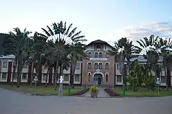 Collège Saint François Xavier Fianarantsoa | |
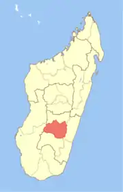 Location in Madagascar | |
| Country |  Madagascar Madagascar |
| Capital | Fianarantsoa |
| Government | |
| • Gouvernor | Lova Narivelo Razafindrafito |
| Area | |
| • Total | 21,080 km2 (8,140 sq mi) |
| Population (2018)[3] | |
| • Total | 1,447,296 |
| • Density | 53.5/km2 (139/sq mi) |
| Time zone | UTC3 (EAT) |
| HDI (2018) | 0.516[4] low · 12th of 22 |
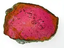
Liddicoatite, a tourmaline from Ambohimahasoa District. Size: 5.8 x 4.7 x 0.4 cm., polished slice.
Administrative divisions
Haute Matsiatra Region is divided into seven districts, which are sub-divided into 84 communes.
- Ambalavao District - 17 communes; 215,094 inhabitants
- Ambohimahasoa District - 17 communes; 220,525 inhabitants
- Fianarantsoa District - 1 commune; 195,478 inhabitants
- Ikalamavony District - 8 communes; 91,797 inhabitants
- Isandra District - 13 communes; 132,971 inhabitants
- Lalangina District - 13 communes; 174,165 inhabitants
- Vohibato District - 15 communes; 201,666 inhabitants
Transport
Airports
- Ambalavao Airport
- Fianarantsoa Airport
Rivers
The main river is the Matsiatra.
Mayor roads
- National road 7 (Antananarivo - Tulear)
- National road 25 ((Fianarantsoa - Mananjary)
- National road 45 - shortcut to National road 25.
Protected areas
- Part of Fandriana-Vondrozo Corridor
- Andringitra National Park
- Part of Ranomafana National Park
- Anja Community Reserve
See also
References
- EDBM
- Ralison, Eliane; Goossens, Frans. "Madagascar: Profil des marchés pour les évaluations d'urgence de la sécurité alimentaire" (PDF) (in French). Programme Alimentaire Mondial, Service de l’Evaluation des besoins d’urgence (ODAN). Retrieved 2008-03-01.
- "Troisieme Recensement General de la Population et de L'Habitation (RGPH-3) Resultats Provisoires" (PDF). Institut National de la Statistique Madagascar. Retrieved May 23, 2020.
- "Sub-national HDI - Area Database - Global Data Lab". hdi.globaldatalab.org. Retrieved 2018-09-13.
Capital: Fianarantsoa | ||
| Ambalavao (17) - 303 | | |
| Ambohimahasoa (17) - 305 | ||
| Fianarantsoa (1) - 301 | ||
| Ikalamavony (8) - 314 | ||
| Isandra (13) - 314 | ||
| Lalangina (13) - 303 | ||
| Vohibato (15) - 305 | ||
Total: 7 districts; 84 communes | ||
This article is issued from Wikipedia. The text is licensed under Creative Commons - Attribution - Sharealike. Additional terms may apply for the media files.