Ilha de Boipeba
Ilha de Boipeba (transl. Boipeba Island) is an island located in the Cairu municipality in Brazil. It is located near the Ilha de Tinharé and is part of the Cairu Archipelago. The island is surrounded on the east by the Atlantic Ocean and on the west by the "Rio de l'Enfer" estuary.
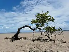 The coast of Boipeba | |
| Geography | |
|---|---|
| Coordinates | 13°37′24″S 38°54′23″W |
| Archipelago | Cairu Archipelago |
| Area | 88 km2 (34 sq mi) |
| Highest elevation | 6 m (20 ft) |
| Administration | |
| Region | Northeast Region |
| State | Bahia |
| Municipality | Cairu |
| Demographics | |
| Population | 3,256[1] (2010) |
| Pop. density | 37/km2 (96/sq mi) |
| Ethnic groups | Tupi |
It is a popular tourist destination due to its scenic beaches and rainforest, which makes up the majority of the islands economy along with fishing.[2][3]
The island has a total area of 88 square kilometers and a population of 3,256 as of 2010. There are four villages located on the island: Velha Boipeba, São Sebastião, Moreré, and Monte Alegre.[2] The island also has several beaches: Praia da Boca da Barra, Praia de Tassimirim, Praia da Cueira, Praia de Moreré, Praia de Bainema, Praia da Cova da Onça, Praia da Ponta dos Castelhanos
The island was first settled in 1537 by Jesuits from Portugal, making it one of the oldest settled places in the state of Bahia. The Church of Divino Espírito Santo, built in 1610, is the island's most important monument.[2]
The name Boipeba comes from the word "M'boi pewa" in the Tupi language, which means "flat snake", the native name for the sea turtle.[2]
See also
References
- "Bahia (Brazil): Municipalities and Municipal Districts". Citypopulation.de. Retrieved 1 December 2021.
- "Ilha de Boipeba". ilhaboipeba.org.br. Retrieved 1 December 2021.
- "Ilha de Boipeba é eleita na internet a mais bonita do Brasil". atarde.uol.com.br. 27 March 2013. Retrieved 1 December 2021.
