Interstate 20 in Mississippi
Interstate 20 (I-20) is a major thoroughfare through the central region of the U.S. state of Mississippi. Spanning 154.5 miles (248.6 km), it connects Jackson and I-55 with Vicksburg and the Mississippi River in the west and Meridian and I-59 in the east.
 | ||||
|---|---|---|---|---|
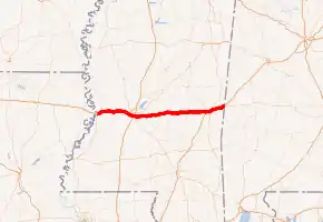
I-20 highlighted in red | ||||
| Route information | ||||
| Maintained by MDOT | ||||
| Length | 154.5 mi[1] (248.6 km) | |||
| Major junctions | ||||
| West end | I-20 at Vicksburg | |||
| East end |  I-20 / I-59 at the Alabama line I-20 / I-59 at the Alabama line | |||
| Location | ||||
| Counties | Warren, Hinds, Rankin, Scott, Newton, Lauderdale | |||
| Highway system | ||||
| ||||

Route description
Interstate 20 enters the state from Louisiana across the Mississippi River where it immediately enters the city of Vicksburg. Between Vicksburg and Jackson, I-20 enters several low-lying communities.
Between Edwards and Clinton, I-20 uses the original U.S. 80 alignment, except for a short bypass around Bolton.
In Jackson, I-20 briefly merges with Interstate 55 before separating just east of the Pearl River. The old directional interchange at I-55 North and cloverleaf at U.S. Highway 49 South have been combined / replaced with a new interchange which features both loop and/or flyover ramps, plus several C/D lanes providing direct connections for the most heavily traveled routes.
Just west of Meridian, Interstate 59 joins I-20 at what is locally known as "The Split", and the two highways run concurrently through the city and on to Birmingham, Alabama. Throughout the Mississippi portion of this concurrency, I-59's mileage takes over I-20's.
The Mississippi Department of Transportation recently announced plans to reconstruct I-20 through Vicksburg. The project includes the replacement and/or enhancement of all interchanges, additional lanes throughout the city and a new bridge to close a decades-old break in the south frontage road. Environmental studies are ongoing.
Exit list
| County | Location | mi | km | Exit | Destinations | Notes |
|---|---|---|---|---|---|---|
| Mississippi River | 0.00 | 0.00 |  I-20 west / US 80 west – Monroe I-20 west / US 80 west – Monroe | Continuation into Louisiana | ||
| Vicksburg Bridge; Louisiana–Mississippi state line | ||||||
| Warren | Vicksburg | 0.44 | 0.71 | 1A | Washington Street, Warrenton Road (US 61 Bus.) | |
| 1.19 | 1.92 | 1B |  US 61 south – Natchez, Baton Rouge US 61 south – Natchez, Baton Rouge | Western end of US 61 overlap | ||
| 1.94 | 3.12 | 1C | Halls Ferry Road | |||
| 3.21 | 5.17 | 3 | Indiana Avenue | |||
| 4.65 | 7.48 | 4 | Clay Street – Vicksburg National Military Park, Downtown Vicksburg | Signed as exits 4A (east) and 4B (west); westbound exit to Clay Street east and eastbound entrance to eastbound I-20 are via exit 5B | ||
| 5.51 | 8.87 | 5A | US 61 north – Rolling Fork, Yazoo City, Memphis | Eastern end of US 61 overlap | ||
| 5B |  MS 27 south – Utica MS 27 south – Utica | Westbound entrance is via exit 4B | ||||
| | 11.15 | 17.94 | 11 | Bovina | ||
| | 15.11 | 24.32 | 15 | Flowers | ||
| Hinds | | 19.60 | 31.54 | 19 |  MS 22 – Flora, Edwards MS 22 – Flora, Edwards | |
| Bolton | 27.58 | 44.39 | 27 | Bolton | ||
| | 31.69 | 51.00 | 31 | Norrell Road | ||
| Clinton | 34.14 | 54.94 | 34 | Natchez Trace Parkway | ||
| 35.25 | 56.73 | 35 | US 80 east / Clinton-Raymond Road | Eastern end of US 80 overlap | ||
| 36.15 | 58.18 | 36 | Springridge Road | |||
| Jackson | 40.30 | 64.86 | 40 |  MS 18 west / Robinson Road – Raymond MS 18 west / Robinson Road – Raymond | Signed as exits 40A (west) and 40B (east) westbound | |
| 41.35 | 66.55 | 41 |   I-220 / US 49 north – North Jackson, Yazoo City I-220 / US 49 north – North Jackson, Yazoo City | Western end of US 49 overlap; I-220 no number signed | ||
| 42.64 | 68.62 | 42 | Ellis Avenue | Signed as exits 42A (south) and 42B (north) | ||
| 43.82 | 70.52 | 43 | Terry Road | Signed as exits 43A (south) and 43B (north) | ||
| 44.23 | 71.18 | 44 |   I-55 south / US 51 south / McDowell Road – McComb, New Orleans I-55 south / US 51 south / McDowell Road – McComb, New Orleans | Western end of I-55 overlap; I-55 exit 92C | ||
| 45.08 | 72.55 | 45A | Gallatin Street | Eastbound exit is part of exit 45 | ||
| 45.51 | 73.24 | 45B | US 51 north (State Street) | Signed as exit 45 eastbound | ||
| Rankin | Richland | 46.17 | 74.30 | 46 | I-55 north – Grenada, North Jackson, Memphis | Eastern end of I-55 overlap; I-55 exit 94 |
| 47.16 | 75.90 | 47 | US 49 south – Hattiesburg, Flowood | Eastern end of US 49 overlap; signed as exits 47A (south) and 47B (north) eastbound | ||
| Pearl | 48.72 | 78.41 | 48 |  MS 468 – Pearl MS 468 – Pearl | ||
| 52.32 | 84.20 | 52 |  MS 475 – Jackson-Evers International Airport MS 475 – Jackson-Evers International Airport | |||
| Brandon | 54.53 | 87.76 | 54 | Crossgates Boulevard, Greenfield Road | Former MS 18 | |
| 56.61 | 91.10 | 56 | US 80 – Downtown Brandon | |||
| 59.70 | 96.08 | 59 | US 80 – East Brandon | |||
| Pelahatchie | 68.65 | 110.48 | 68 |  MS 43 – Puckett, Pelahatchie MS 43 – Puckett, Pelahatchie | ||
| Scott | | 76.90 | 123.76 | 77 |  MS 13 – Puckett, Morton MS 13 – Puckett, Morton | |
| | 80.04 | 128.81 | 80 |  MS 481 – Raleigh, Morton MS 481 – Raleigh, Morton | ||
| Forest | 88.04 | 141.69 | 88 |  MS 35 – Raleigh, Forest MS 35 – Raleigh, Forest | ||
| | 96.57 | 155.41 | 96 | Lake | ||
| Newton | | 99.94 | 160.84 | 100 | US 80 – Lake, Lawrence | |
| Newton | 108.92 | 175.29 | 109 |  MS 15 – Newton, Philadelphia MS 15 – Newton, Philadelphia | ||
| | 114.48 | 184.24 | 115 |  MS 503 – Hickory, Decatur MS 503 – Hickory, Decatur | ||
| | 121.10 | 194.89 | 121 | Chunky | ||
| Lauderdale | Meridian | 129.30 | 208.09 | 129 | US 80 west – Lost Gap, Meehan Junction | Western end of US 80 overlap |
| 130.74 | 210.41 | 130 | I-59 south – Laurel, New Orleans | Western end of I-59 overlap, north exit 149; no exit number westbound | ||
| 133.00 | 214.04 | 150 |   US 11 south / MS 19 north – Meridian Airport, Philadelphia US 11 south / MS 19 north – Meridian Airport, Philadelphia | Western end of US 11/MS 19 overlap Exits follow I-59's mile markers | ||
| 133.47 | 214.80 | 151 | Valley Road, 49th Avenue | |||
| 134.42 | 216.33 | 152 | 29th Avenue | |||
| 135.63 | 218.28 | 153 |  MS 145 south / 22nd Avenue – Quitman MS 145 south / 22nd Avenue – Quitman | |||
| 137.08 | 220.61 | 154 |  MS 19 south / MS 39 north / US 11 north / US 80 east – Butler, De Kalb MS 19 south / MS 39 north / US 11 north / US 80 east – Butler, De Kalb | Eastern end of US 11/US 80/MS 19 overlap; signed as exits 154A (south) and 154B (north) eastbound | ||
| 138.43 | 222.78 | 156 | Jimmy Rodgers Parkway | |||
| 139.51 | 224.52 | 157 |  US 45 – Quitman, Macon US 45 – Quitman, Macon | Signed as exits 157A (south) and 157B (north) | ||
| | 142.94 | 230.04 | 160 | Russell | ||
| | 147.46 | 237.31 | 165 | Toomsuba | ||
| | 151.12 | 243.20 | 169 | Kewanee (US 11 / US 80) | ||
| | 154.42 | 248.51 | I-20 east / I-59 north – Birmingham | Continuation into Alabama | ||
1.000 mi = 1.609 km; 1.000 km = 0.621 mi
| ||||||
References
- "Mississippi Public Roads. Selected Statistics. Extent, Travel, and Designation" (PDF). Mississippi Department of Transportation. 2011. Retrieved 28 April 2013.
External links
 |
Wikimedia Commons has media related to Interstate 20 in Mississippi. |
- "Interstate 20 Eastbound." Mississippi @ SoutheastRoads.com
- "Interstate 20 Westbound." Mississippi @ Southeast Roads.com
- "I-20 Exits: Mississippi River to I-55"
- "I-20 Exits: I-55 South to I-59 South"