Javary River
The Javary River, Javari River or Yavarí River (Spanish: Río Yavarí; Portuguese: Rio Javari) is a 1,184 km (736 mi) tributary of the Amazon that forms the boundary between Brazil and Peru for more than 500 mi (800 km).[2] It is navigable by canoe for 900 mi (1,400 km) from above its mouth to its source in the Ucayali highlands, but only 260 were found suitable for steam navigation.
| Javary River Javari River | |
|---|---|
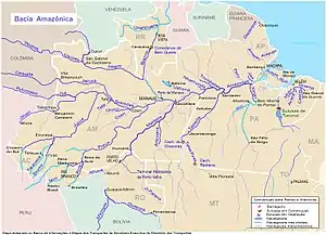 Javary/Javari on the far left (only lower part of river highlighted on this map) | |
| Location | |
| Country | Brazil, Peru |
| Physical characteristics | |
| Source | |
| • location | Sierra de Contamana, Ucayali, Peru |
| Mouth | Amazon River |
• location | Amazonas, Brazil |
| Length | 1,184 km (736 mi) |
| Basin size | 98,366 km2 (37,979 sq mi) |
| Discharge | |
| • location | mouth |
| • average | 4,545 m3/s (160,500 cu ft/s)[1] |
| Basin features | |
| Tributaries | |
| • left | Curuça River, Ituí River |
| • right | Galves River, Yavari-mirim River |
The Brazilian Boundary Commission ascended it in 1866 to the junction of the Shino with its Jaquirana branch. The country it traverses in its extremely sinuous course is very level, similar in character to that of the Juruá.
There are a number of small private reserves along the river, which arrange wildlife viewing.[3]
The town of Benjamin Constant lies at the mouth of the river, on the Brazilian bank.
References
- (PDF) http://meioambiente.am.gov.br/wp-content/uploads/2016/04/Produto-II-Diagn%25C3%25B3stico-Progn%25C3%25B3stico-e-Cen%25C3%25A1rios-volume-II.pdf. Missing or empty
|title=(help) - The Nation, Volume 50
- Woods, Sarah (2008). Colombia. Bradt Travel Guides. pp. 254ff. ISBN 9781841622422.
Authority control  |
|---|