K-33 (Kansas highway)
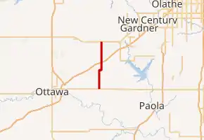
K-33 is an approximately 10.4-mile-long (16.7 km) north–south state highway in the U.S. state of Kansas. K-33's southern terminus is at K-68 in rural Franklin County east of Ottawa and the northern terminus is at U.S. Route 56 (US-56) in Douglas County, east of Baldwin City and southwest of Kansas City. K-33 provides an important link between US-56 and K-68 to Interstate 35 (I-35) and US-50 in Wellsville. K-33 is a two-lane rural highway for most of its length except for the section within Wellsville.
 | ||||
|---|---|---|---|---|
K-33 in red | ||||
| Route information | ||||
| Maintained by KDOT | ||||
| Length | 10.405 mi[1] (16.745 km) | |||
| Existed | 1926[2]–present | |||
| Major junctions | ||||
| South end |  K-68 east of Ottawa K-68 east of Ottawa | |||
  I-35 / US-50 in Wellsville I-35 / US-50 in Wellsville | ||||
| North end |  US-56 east of Baldwin City US-56 east of Baldwin City | |||
| Location | ||||
| Counties | Franklin, Douglas | |||
| Highway system | ||||
| ||||


Before state highways were numbered in Kansas, there were auto trails. The majority of K-33's route closely follows the former New Santa Fe Trail, King of Trails and Ozark Trails. K-33 was first designated a state highway in 1926, to a highway from near Waverly northeastward to Ottawa then east to the Missouri border. By 1927, K-33 was realigned to turn north, just west of Ottawa, then pass through Wellsville to Edgerton. By 1934, the northern terminus of K-33 was realigned to the west of Edgerton. By 1936, K-33's southern terminus was truncated to Ottawa. By 1969, the overlap with K-68 was eliminated and K-33 was truncated to its current southern terminus.
Route description
.jpg.webp)
K-33's southern terminus is at an intersection with K-68 east of Ottawa in Franklin County. It starts travelling north on a two-lane road through rolling plains. After approximately 1.6 miles (2.6 km) the highway crosses Hickory Creek. K-33 continues roughly 2.4 miles (3.9 km) then the route curves to the east momentarily before curving back to the north. The highway continues north for 2.6 miles (4.2 km) then reaches a diamond interchange with I-35 and US-50 at exit 198. North of this interchange, K-33 enters the city of Wellsville as Poplar Street. It continues north through the city and soon crosses over a BNSF Railway track.[3] Continuing north, K-33 leaves the city at 1st Street.[4] The highway soon crosses an unnamed tributary of Rock Creek then enters into Douglas County roughly 0.7 miles (1.1 km) later.[5] The highway continues through a mix of farmland and scattered areas of trees for about two miles (3.2 km) and reaches its northern terminus at US-56 east of Baldwin City.[6][7]
The Kansas Department of Transportation (KDOT) tracks the traffic levels on its highways, and in 2019, they determined that on average the traffic varied from 1,570 vehicles per day near the southern terminus to 5,130 vehicles per day between I-35/US-50 and Wellsville. The second highest was 2,610 vehicles per day slightly south of I-35 and US-50.[8] K-33 is not included in the National Highway System, which is a system of highways important to the nation's defense, economy, and mobility. K-33 does connect to the National Highway System at I-35 and US-50 as well as at its northern terminus.[9][10]
History
Prior to the formation of the Kansas state highway system, there were auto trails, which were an informal network of marked routes that existed in the United States and Canada in the early part of the 20th century. The majority of K-33's route closely follows the former New Santa Fe Trail, King of Trails and Ozark Trails.[11]
K-33 was first designated a state highway in 1926, and at that time went from US-75 and US-250 by Waverly northeastward to Ottawa then east to the Missouri border.[2] By 1927, US-250 was renumbered US-50S and K-33 was realigned to travel north to Wellsville, then northeastward to US-50 in Edgerton.[12][13] By 1928, K-33 was realigned to intersect K-31 east of Waverly then follow the latter west to US-50S.[14] By 1934, US-50S was realigned to follow K-33 from west of Waverly to Ottawa and K-68 was extended west on the old US-50S alignment from Ottawa to US-75 by Lyndon. Also at this time, the northern terminus of K-33 was realigned to end at US-50 west of Edgerton.[15][16] By 1936, K-33 was truncated to end at US-50S and US-73 in Ottawa.[16][17] On June 27, 1956, the AASHO Route Numbering Committee approved US-56 to be created. US-56 was routed over US-50 from Kansas City westward to US-59 then followed US-50N, which was eliminated. Also at this time US-50S was renumbered to US-50.[18] By 1963, the section of I-35 from Ottawa to Kansas City was built and US-50 had been realigned to overlap I-35.[19] By 1969, the overlap with K-68 was eliminated and K-33 was truncated to its current southern terminus.[20][21]
Major intersections
| County | Location | mi[1] | km | Destinations | Notes |
|---|---|---|---|---|---|
| Franklin | Peoria Township | 0.000 | 0.000 |   K-68 to US-169 – Ottawa K-68 to US-169 – Ottawa | Southern terminus; road continues as Virginia Road |
| Franklin Township | 6.044 | 9.727 | I-35 / US-50 – Wichita, Kansas City | Diamond interchange; I-35 exit 198 | |
| Douglas | Palmyra Township | 10.405 | 16.745 | US-56 (North 200 Road) – Baldwin City, Olathe | Northern terminus; road continues as E 2300 Road |
| 1.000 mi = 1.609 km; 1.000 km = 0.621 mi | |||||
References
- Staff (2016). "Pavement Management Information System". Topeka: Kansas Department of Transportation. Retrieved April 16, 2017.
- Rand McNally and Company (1926). "Kansas" (Map). Rand McNally Auto Road Atlas of the United States, including a Brief Description of the National Parks and Monuments. Chicago: Rand McNally and Company. pp. 56–57.
- "Kansas Railroad Map 2011" (PDF). Topeka: Kansas Department of Transportation. April 1, 2011. Retrieved February 13, 2013.
- Bureau of Transportation Planning (April 1, 2011). City of Wellsville (PDF) (Map). Scale not given. KDOT City Maps. Topeka: Kansas Department of Transportation. Retrieved November 3, 2020.
- Bureau of Transportation Planning (October 2009). Franklin County (PDF) (Map). [c. 1: 211,200]. General Highway Map. Topeka: Kansas Department of Transportation. Retrieved November 3, 2020.
- Google (February 13, 2013). "K-33 (Kansas highway)" (Map). Google Maps. Google. Retrieved February 13, 2013.
- Bureau of Transportation Planning (May 2010). Douglas County (PDF) (Map). [c. 1: 211,200]. General Highway Map. Topeka: Kansas Department of Transportation. Retrieved November 3, 2020.
- Bureau of Transportation Planning (2020). Traffic Flow Map Kansas State Highway System (PDF) (Map). [c. 1:1,584,000]. Topeka: Kansas Department of Transportation. Retrieved October 26, 2020.
- Federal Highway Administration (May 8, 2019). National Highway System: Kansas (PDF) (Map). [c. 1:3,900,000]. Washington, DC: Federal Highway Administration. Retrieved September 15, 2019.
- Natzke, Stefan; Neathery, Mike; Adderly, Kevin (September 26, 2012). "What is the National Highway System?". National Highway System. Washington, DC: Federal Highway Administration. Retrieved September 15, 2019.
- Rand McNally and Company (1924). "Kansas" (Map). AutoTrails Map, Southern Nebraska, Eastern Colorado, Kansas, Northeastern New Mexico, Northern Oklahoma. 1:1,600,000. Chicago: Rand McNally and Company. OCLC 2078375. Retrieved November 3, 2020 – via Rumsey Collection.
- Rand McNally and Company (1927). "Kansas" (Map). Rand McNally Auto Road Atlas of the United States and Ontario, Quebec, and the Maritime Provinces of Canada, with a Brief Description of the National Parks and Monuments. 1:1,600,000. Chicago: Rand McNally and Company. pp. 54–55. OCLC 2078375. Retrieved March 14, 2021 – via Rumsey Collection.
- National Map Company (1927). "Kansas" (Map). Sectional paved road map. 1:1,600,000. Indianapolis: National Map Company. pp. 18–19. OCLC 4048012. Retrieved March 14, 2021 – via Rumsey Collection.
- Clason Map Company (1928). "Kansas" (Map). Clason's Touring Atlas of the United States and Canada. Denver: Clason Map Company. p. 37.
- State Highway Commission of Kansas (1933). Kansas State Highway System (PDF) (Map). Scale not given. Topeka: State Highway Commission of Kansas. Retrieved October 14, 2020.
- Continental Oil Company (1934). Kansas (Map). Denver: Continental Oil Company.
- State Highway Commission of Kansas (1936). 1936 Franklin County Map (PDF) (Map). Scale not given. Topeka: State Highway Commission of Kansas. Retrieved March 14, 2021.
- Oklahoma Department of Transportation, Chronological History Documentation: US 56 (correspondence between ODOT, AASHO, and other DOTs)
- State Highway Commission of Kansas (1963). 1963-64 Kansas State Map (PDF) (Map). Scale not given. Topeka: State Highway Commission of Kansas. Retrieved September 4, 2019.
- State Highway Commission of Kansas (1947). 1947 Franklin County Map (PDF) (Map). Scale not given. Topeka: State Highway Commission of Kansas. Retrieved September 4, 2019.
- State Highway Commission of Kansas (1969). 1969 Franklin County Map (PDF) (Map). Scale not given. Topeka: State Highway Commission of Kansas. Retrieved September 4, 2019.