Kamigōri, Hyōgo
Kamigōri (上郡町, Kamigōri-chō) is a town located in Akō District, Hyōgo Prefecture, Japan.
Kamigōri
上郡町 | |
|---|---|
Town | |
 Kamigōri town hall | |
 Flag  Emblem | |
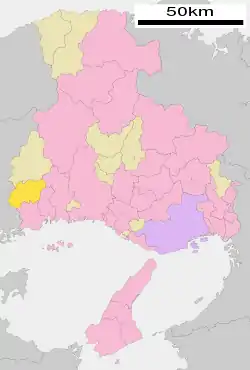 Location of Kamigōri in Hyōgo Prefecture | |
  Kamigōri Location in Japan | |
| Coordinates: 34°52′N 134°21′E | |
| Country | Japan |
| Region | Kansai |
| Prefecture | Hyōgo Prefecture |
| District | Akō |
| Government | |
| • Mayor | Yutaka Tōyama |
| Area | |
| • Total | 150.28 km2 (58.02 sq mi) |
| Population (May 1, 2017) | |
| • Total | 15,448 |
| • Density | 100/km2 (270/sq mi) |
| Time zone | UTC+09:00 (JST) |
| Website | www |
| Symbols | |
| Flower | Dahlia |
| Tree | Camellia japonica |
As of May 2017, the town had an estimated population of 15,448 and a density of 100 persons per km².[1] The total area is 150.28 km².
Geography
Notable places
- Shirahata Castle - A castle ruin, built by Akamatsu Norimura.
References
- "Official website of Kamigōri Town" (in Japanese). Japan: Kamigōri Town. Retrieved 14 May 2017.
External links
 Media related to Kamigōri, Hyōgo at Wikimedia Commons
 Geographic data related to Kamigōri, Hyōgo at OpenStreetMap
- Kamigōri official website (in Japanese)
| Kobe |
|  | ||
|---|---|---|---|---|
| Core cities | ||||
| Special cities | ||||
| Cities | ||||
| Districts | ||||


This article is issued from Wikipedia. The text is licensed under Creative Commons - Attribution - Sharealike. Additional terms may apply for the media files.