Kingsthorpe
Kingsthorpe is a northern suburb and civil parish of Northampton, England. The 2011 Census recorded the population of the district council ward as 4,477.[1]
| Kingsthorpe | |
|---|---|
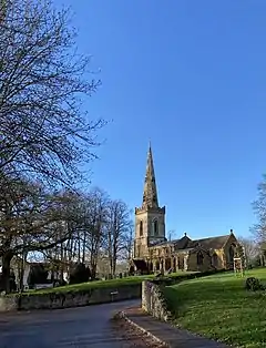 St John the Baptist church from the village green | |
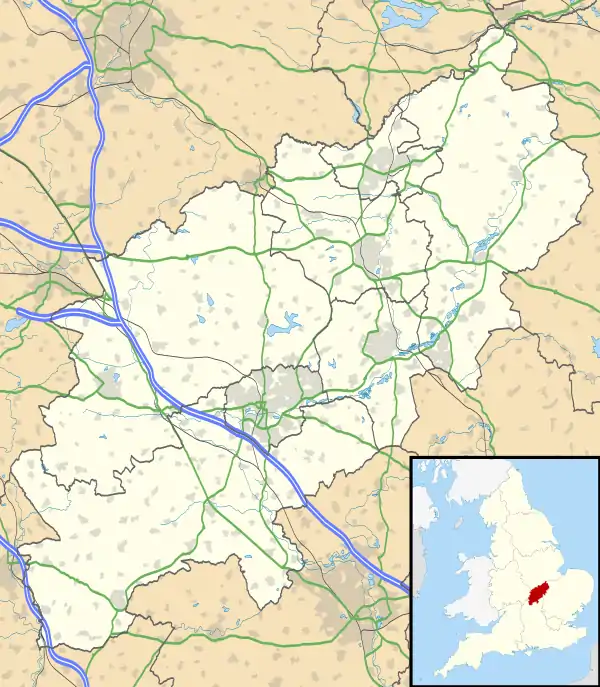  Kingsthorpe Location within Northamptonshire | |
| Population | 4,477 (Ward, 2011) |
| OS grid reference | SP7463 |
| • London | 70 miles (113 km) |
| Civil parish |
|
| Unitary authority | |
| Ceremonial county | |
| Region | |
| Country | England |
| Sovereign state | United Kingdom |
| Post town | Northampton |
| Postcode district | NN2 |
| Dialling code | 01604 |
| Police | Northamptonshire |
| Fire | Northamptonshire |
| Ambulance | East Midlands |
| UK Parliament | |
For centuries, Kingsthorpe was a rural village, with a parish of 1,020 acres (410 ha) and history dating back to the 9th century. In the 19th century, it was made a civil parish. [2] Most of the parish was absorbed into the borough of Northampton in 1900; the remainder of it followed in 1931.[3] The original ecclesiastical parish of Kingsthorpe was gradually divided up amongst new parishes following the building of new housing in the 19th and 20th centuries.
Kingsthorpe is a residential area of Northampton. It is now made up of several neighbourhoods which surround its central shopping front, which includes supermarkets, cafes and various independent retailers. In 2020, Kingsthorpe Parish Council was formed.[4]
Geography
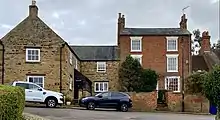
Kingsthorpe Village lies approximately two miles north of the town centre and to the west of the A508. It is situated on sloping land overlooking the tributary of the River Nene called the Naseby Source or Brampton Nene, which flows through the area to the west from north to south.
The village green retains a semi-rural character, away from the main roads, overlooked by the parish church and vernacular cottages. The suburb's amenities are centred on the main A508 and A5199 roads that link central Northampton with Market Harborough and Leicester respectively
Areas considered part of Kingsthorpe have since grown around the original village, with residential development mainly to the north and either side of the A508 and A5199 roads. The parish of Kingsthorpe covers a large area split into 5 wards: Kingsthorpe, Obelisk, St Davids, Spring Park and Sunnyside.
History
The place-name is derived from the Old English cyning and Old Danish torp, meaning the King's hamlet or farmstead.[5] In earlier centuries the village was called simply Torp (11th century) or Thorp (12th and 13th centuries). It was only in the 14th century that it started to be called Kyngesthorpe.[3]
Kingsthorpe was mentioned in the Domesday Book in 1085 when it was known as Kingstorp; at that time it formed part of the demesne of the Crown. The Domesday Book also made reference to three water mills, which were later known as North (or Farre) Mill (being furthest from the village), the Nether Mill in the village, and the South Mill nearer to Northampton.[6] Milling in Kingsthorpe continued into the 20th century, when all the mills were demolished.
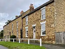
The historic core of the village is centred on the village green and the 12th century Church of St John the Baptist. The original parish of Kingsthorpe was large and extended to approximately 1743 acres in 1767,[6] incorporating areas that would now be considered neighbourhoods of present-day Kingsthorpe, as well as parts of present-day Abington to the east, and parts of the present-day Queen's Park and Semilong estates to the south.[6]
Some of the oldest buildings in the village, which date back to the 17th century, include Kingswell Cottage on The Green; stone cottages in Well Yard; and the Home Farm farmhouse, Dovecote and Barn on Kingswell Road.[7]
The Queen Adelaide public house on Manor Road dates back to the 18th century,[8] while the Cock Hotel on the Harborough Road dates back to 1893. The present Cock Hotel building replaced an older coaching inn which dated back to the 16th century.[9] Opposite the Cock sits the Kingsthorpe War Memorial dating back from 1921.[10]
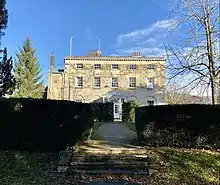
Kingsthorpe Hall (formely Thornton Hall) was built circa 1775. The hall and surrounding parkland was sold to the local council in 1937. Thornton Park is now a popular public park.[11]
By 1831, the population of Kingsthorpe had reached 1,344.
In 1835, the Kingsthorpe Baptist Chapel opened on the High Street.[12] The Catholic Church of St. Aidan on Manor Road opened in 1964.[13]
In 1882, the current St Davids Hospital was constructed on the site of the original hospital founded in 1200.[14] The building was later used as a school and is now a rehabilitation care home for adults with brain injuries.
In 1898, the Kingsthorpe Cemetery opened the eastern side of the Harborough Road, where it has remained since. The cemetery is part of the Commonwealth War Graves Commission. In 1899, a hospital was erected at the northern end of the Welford Road which was used to treat infectious diseases[6] – this was closed down in the 1970s and demolished to make way for Cedrus Court, a new housing development.
In 1900, the village was incorporated into the County Borough administrative area. In 1912, the local council acquired 21 acres on the east of the Welford Road from the Thornton estate, which later became the Recreation Ground (or 'The Rec' for short) where there were facilities for cricket, football, tennis and bowls as well as a children's playground.[6]
By the 1930s, there was a parade of shops on the Harborough Road, known as Alexandra Terrace, with the Bective shoe and boot factory on the other side of the road.[6] There were also facilities for croquet and tennis at the junction of the A508 and A5199 roads. Housing development had been completed in Kingswell Road, Washington Street, Lincoln Street and Garfield Street.[6] There were also dwellings in Bective Road, Newington Road and parts of Yelvertoft and Norton Roads.[6] Houses had been built on the south side of Boughton Green Road and Ruskin Road had been developed as well as the beginning of St Davids estate to the west of Eastern Avenue.[6] There were also two schools in the area, and another in Kingsthorpe Grove.
In the early part of the 20th century, more housing was also built along the west side of Welford Road as well as on parts of North Western Avenue, Foxgrove Avenue and Kingsway. On the Harborough Road, Glan-y-mor Terrace had been built.[6] Further along, opposite the Cemetery, the White Hills estate had started to be built. During the second half of the 20th century, housing estates and some industrial developments filled the remaining portions of land within the boundaries of the old parish.[6] In the 1960s, the Chalcombe Avenue and Hinton Road estates were built. Between the late 1960s and 1970s, the Spring Park estate (which includes Acre Lane, Rookery Lane and Sherwood Avenue) was developed in the west, followed in the east by Obelisk estate, which ushered in the construction of Holly Lodge Drive.
in 1974, the Kingsthorpe Shopping Centre opened. It included shops, a post office, a pub and a Waitrose supermarket. In the early 2000s, alrerations were made to demolish part of the centre to extend Waitrose and its car park. In 1986, a new supermarket was built next to Waitrose. It operated as Safeway for a number of years but is now an Asda supermarket.
The historic core was designated as a Conservation Area in 1971 and was one of the first such areas in Northampton. The boundary of the conservation area was extended in 1976 to incorporate Vicarage Lane and Kingswell Road. A second Conservation Area was designated in 1987, which envelops Manor Road and High Street. The Conservation Areas contain a variety of domestic buildings, including cottages and houses made from local sandstone and brick. A number of buildings are listed and tree preservation orders cover a number of the trees in the village. There are also many footpaths and small lanes across the village. Road traffic now mainly flows into the village from Mill Lane in the south into Kingswell Road or via High Street in the north leading straight into the village.
Parish church
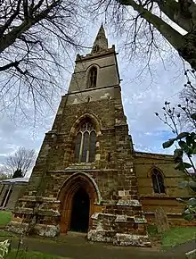
The Church of England parish church of St John the Baptist was built in the 11th century and still has remains of some original late Anglo-Saxon or early Norman windows.[15] It is a Grade I listed building.[15]
The north chapel and north and south aisles were added about 1170–80.[16] The church had a south chapel by about 1180. Part of the chancel was built in about 1220. In the 14th century the crypt was built, the chapels were extended eastward and most of the current windows were inserted.[15]
The west tower and recessed spire are 14th-[17] or 15th-century.[15] The tower has a ring of six bells. Robert Atton of Buckingham cast the second bell in 1621 and the fifth bell in 1622. Henry I Bagley of Chacombe cast the tenor bell in 1671 and Henry II Bagley cast the third bell in 1680. Alfred Bowell of Ipswich, Suffolk cast the treble and fourth bells in 1911.[18]
The pulpit is Jacobean. There is a monument to Edward Reynolds, who died in 1698.[17]
The church was restored in 1863 under the direction of the architect William Slater.[17]
Economic and social history
The Dallington Iron Ore Co Ltd briefly quarried iron ore north of the village. The quarry was between what is now the A5199 and the then railway to Market Harborough (now disused). The quarry operated from 1859 to 1861 or slightly longer. The ore was taken away by rail. The site of the quarry is now covered by housing.[19]
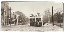
A Northampton Corporation Tramways route served Kingsthorpe until the network was closed[3] at the end of 1934.
Joan Hickson, who played Miss Marple in the Miss Marple BBC television series, was born in the village. Actress Judy Carne's parents were greengrocers in the village. Lesley Joseph, who played Dorien Green in the television comedy series Birds of a Feather, was raised here until the age of 18.[20] One of the campuses of the University of Northampton, the Park Campus, used to be in Kingsthorpe until the university relocated to the Waterside Campus.
See also
References
- "Kingshorpe ward population". Neighbourhood Statistics. Office for National Statistics. Retrieved 5 July 2016.
- "Kingsthorpe". Ordnance Survey. Retrieved 22 October 2020.
- Salzman 1937, pp. 81–88.
- "New councils update". Northampton Town Council. 22 May 2020. Retrieved 22 October 2020.
- Mills 1991, Kingsthorpe.
- Horner, Tony (2005). Kingsthorpe: A Royal Manor Explorer. Léonie Press.
- "HOME FARM HOUSE, Kingsthorpe - 1372225 | Historic England".
- "QUEEN ADELAIDE INN, Kingsthorpe - 1052415 | Historic England".
- "THE COCK HOTEL, Kingsthorpe - 1190566 | Historic England".
- "Kingsthorpe War Memorial, Kingsthorpe - 1456370 | Historic England".
- "Thornton Park needs a face lift". 7 April 2010.
- "Northampton, Kingsthorpe High Street Methodist/Baptist Church".
- "History of St. Aidan's | Catholic Church of St. Aidan".
- "ST DAVid's, Kingsthorpe - 1372196 | Historic England".
- Historic England. "Church of St John the Baptist (Grade I) (1190502)". National Heritage List for England. Retrieved 9 April 2018.
- Pevsner & Cherry 1973, p. 339.
- Pevsner & Cherry 1973, p. 340.
- Dawson, George (14 December 2010). "Kingsthorpe Northampton, Northants S John Bapt". Dove's Guide for Church Bell Ringers. Central Council of Church Bell Ringers. Retrieved 9 April 2018.
- Tonks 1989, pp. 151–152.
- "A 'homecoming' for Lesley Joseph". BBC Online. 22 April 2008.
Bibliography
- Mills, AD (1991). A Dictionary of British Place-Names. Oxford: Oxford University Press. ISBN 0-19-869156-4.
- Pevsner, Nikolaus; Cherry, Bridget (revision) (1973) [1961]. Northamptonshire. The Buildings of England (2nd ed.). Harmondsworth: Penguin Books. pp. 339–341. ISBN 0-14-071022-1.
- RCHME, ed. (1985). "Kingsthorpe". An Inventory of the Historical Monuments in the County of Northamptonshire. 5 – Archaeology and churches in Northampton. London: Royal Commission on the Historical Monuments of England. pp. 300–310.
- Salzman, LF, ed. (1937). A History of the County of Northampton. Victoria County History. IV. London: Oxford University Press for the Institute of Historical Research. pp. 81–88.
- Tonks, Eric (April 1989). The Ironstone Quarries of the Midlands Part 3: The Northampton Area. Cheltenham: Runpast Publishing. p. 151–152. ISBN 1-870-754-034.
External links
 |
Wikimedia Commons has media related to Kingsthorpe, Northampton. |
- "Kingsthorpe in 1839". SDUK Penny Cyclopedia. Old Towns Books & Maps.
The Borough of Northampton | |||||||||||
|---|---|---|---|---|---|---|---|---|---|---|---|
| Suburbs and villages |  | ||||||||||
| Governance | |||||||||||
| Culture |
| ||||||||||
| Education | |||||||||||
| Sport |
| ||||||||||
| Transport | |||||||||||
| |||||||||||