Lakshmipur District
Lakshmipur (Bengali: লক্ষ্মীপুর, romanized: Lokkhipur, also spelt Laxmipur, with an area of 1455.96 km2, is a district of Bangladesh. It is bordered by Chandpur to the north, Bhola and Noakhali districts to the south, Noakhali to the east, and Barisal and Bhola districts to the west.
Lakshmipur
লক্ষ্মীপুর | |
|---|---|
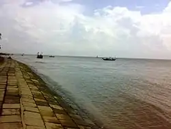 Meghna River at Haidergang Ghat | |
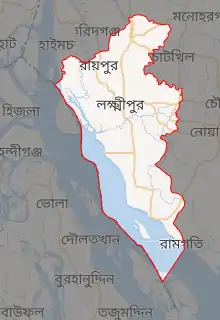
Expandable map of Lakshmipur District | |
| Coordinates: 22.9500°N 90.8250°E | |
| Country |  Bangladesh Bangladesh |
| Division | Chittagong Division |
| Subdivision | 1979 |
| District | 1984 |
| Government | |
| • Deputy Commissioner | Muhammad Anwar Husayn Akand |
| Area | |
| • Total | 1,440.39 km2 (556.14 sq mi) |
| Population (2011 census) | |
| • Total | 1,729,188 |
| • Density | 1,200/km2 (3,100/sq mi) |
| Demonym(s) | Lakshmipuri, Laxmipuri |
| Literacy rate | |
| • Total | 62.26%[1] |
| Time zone | UTC+06:00 (BST) |
| Postal code | 3700 |
| HDI (2018) | 0.596[2] medium · 11th of 21 |
| Website | www |
History
By the 1620s, it said that Muslims had established an outpost near the village of Bhulua which they called Islamabad. Historians have identified it with modern-day Lakshmipur.[3]
During the Bangladesh Liberation War of 1971, Bengali freedom fighters in this area brawled with the Pakistan Army on 7 June at Ramganj Road, demolishing an army jeep and convoy. They launched a surprise attack near Rahmatkhali Bridge on 6 July, killing 70 army soldiers. At Mirganj, another 70 soldiers were killed, including a Major and 41 Rangers, on 25 October. The Fatehpur reservoir in Ramganj was also a place where numerous soldiers were killed. The army managed to capture 14 of the freedom fighters, later murdering them at their camp in Ramganj. 17 soldiers and razakars were murdered during a brawl at Zamindar Hat. On 14 December, Lakshmipur was liberated.[4]
In 1979, Lakshmipur was made a Subdivision of Noakhali District. It became a separate district in 1984.
Administration
The district of Lakshmipur consists of 4 municipalities, 58 union parishads, 514 villages, 3539 mosques, 45 temples, and 1 church.[1]
The upazilas under this district are:[4]
Demographics
As of the 2011 census, the district has a population of 1,729,188. 96.55% are Muslims, 3.44% Hindus.

Education
- Lakshmipur Aliya Madrasa, founded in 1872
- Raipur Alia Madrasa, founded in 1886
- Bhawaniganj Karamatia Senior Madrasa, founded in 1904
- Lakshmipur Government Girl's High School
- Lakshmipur Adarsha Samad Government High School
- Toomchar Islamia Kamil Madrasah, Sadar
- Panpara high School, Ramgonj
- Sreerampur High School, Ramgonj
- Dattapara Ram Ratan Model High School
- Olipur Gov't Primary School, Olipur, Lakshmipur Sadar
- Dalal Bazar N.k. high school (Laksmipur, Dalal Bazar)
- Hazir Hat Millat Govt. School
Notable people
- Mohammad Mohammadullah, 3rd President of Bangladesh
- Nishat Majumdar, first women Everest climber from Bangladesh
- Abdul Matin Chowdhury, 14th vice-chancellor of the University of Dhaka
- A. N. M Momtaz Uddin Choudhury, first vice-chancellor of Islamic University, Bangladesh
- Abdul Mannan, MP for Lakshmipur-4
- Abul Khair Bhuiyan, former MP for Lakshmipur-2
- A.K.M. Shahjahan Kamal, former Minister of Civil Aviation and Tourism
- A. N. M. Shamsul Islam, former MP for Lakshmipur-1
- A. S. M. Abdur Rab, politician and founder of the Jatiya Samajtantrik Dal-JSD
- Chowdhury Khurshid Alam, former MP for Lakshmipur-2
- Gholam Sarwar Husseini, politician and former Pir of Dayra Sharif, Shyampur
- Hafezzi Huzur, founder of Bangladesh Khilafat Andolan
- Harunur Rashid, former MP for Lakshmipur-2
- Husne Ara Shahed, author and writer
- Khairul Enam, former MP for Lakshmipur-3
- M. A. Awal, former MP for Lakshmipur-1
- Mohammad Noman, Jatiya Party politician
- Mohammad Shahid Islam, MP for Lakshmipur-2
- Mohammad Toaha, activist of the Bengali Language Movement and politician
- M. M. Ruhul Amin, 16th Chief Justice of Bangladesh
- Muhammad Abdullah, academic
- Nazim Uddin Ahmed, former MP for Lakshmipur-1
- Selina Parvin, journalist and poet
- Shahiduddin Chowdhury Annie, former MP for Lakshmipur-3
- S I M Nurunnabi Khan, writer and freedom fighter
- Syed Abul Kalam Azad, former treasurer of the University of Dhaka
- Tofail Ahmed, folk researcher
- Tufail Mohammad, Punjabi military officer and second recipient of the Nishan-e-Haider
- Ziaul Haque Zia, former MP for Lakshmipur-1
References
 |
Wikimedia Commons has media related to Lakshmipur District. |
 |
Wikivoyage has a travel guide for Lakshmipur District. |
- লক্ষ্মীপুর জেলা তথ্য বাতায়নে আপনাকে স্বাগতম (in Bengali). Office of the Deputy Commissioner, Lakshmipur. Archived from the original on 23 August 2011. Retrieved 14 February 2012.
- "Sub-national HDI - Area Database - Global Data Lab". hdi.globaldatalab.org. Retrieved 2020-03-18.
- M. I. Borah (1936). Baharistan-I-Ghaybi – Volume II.
- Md. Shajahan (2012). "Lakshmipur District". In Islam, Sirajul; Miah, Sajahan; Khanam, Mahfuza; Ahmed, Sabbir (eds.). Banglapedia: the National Encyclopedia of Bangladesh (Online ed.). Dhaka, Bangladesh: Banglapedia Trust, Asiatic Society of Bangladesh. ISBN 984-32-0576-6. OCLC 52727562. Retrieved 13 December 2021.
- "Bangladesh Population & Housing Census 2011" (PDF). Retrieved 6 July 2021.
| Barisal Division |  | |
|---|---|---|
| Chittagong Division | ||
| Dhaka Division | ||
| Khulna Division | ||
| Mymensingh Division | ||
| Rajshahi Division | ||
| Rangpur Division | ||
| Sylhet Division | ||
Capital: Lakshmipur | ||
| Upazilas | | |
| Constituencies | ||
| Attractions and sites | ||
| History | ||
| Inhabited areas | ||
| Rivers and transport | ||
| Educational institutions | ||
| See also |
| |
Authority control  | |
|---|---|
| General | |
| National libraries | |
| Other | |