Lambton Quay
Lambton Quay (once known as 'The Beach') is the heart of the central business district of Wellington, the capital city of New Zealand.[1][2]
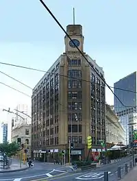 The MLC Building near the south end of Lambton Quay, at Hunter St | |||
| Maintained by | Wellington City Council | ||
|---|---|---|---|
| Location | Wellington, New Zealand | ||
| Postal code | 6011 | ||
| North end | Featherston Street/Mulgrave Street/Thorndon Quay | ||
| South end | Customhouse Quay/Willeston Street/Willis Street | ||
Originally, as the name implies, it was the high-water line of the foreshore, and sometimes the sea would roll across the road and enter the shops on the opposite side.[3] It was the site of the original European settlement in 1840 (following initial settlement on flood-prone land at Petone), which grew into Wellington.[4] In the 19th century Pipitea Pa was situated at the extreme northern end of Lambton Quay - the section of road in this area is now known as Thorndon Quay.[5] Land uplift caused by the 1855 Wairarapa earthquake and further reclamation have left Lambton Quay some 250 metres from the current shoreline.[1][6] Kumototo Stream used to flow from the Terrace, down what is now Woodward Street and across Lambton Quay to the waterfront. This stream was culverted in the late 19th century.[7]
Lambton Quay is named after John Lambton, 1st Earl of Durham, the first chairman of directors of the New Zealand Company.[1]
Lambton Quay, Willis Street and Courtenay Place form what is known locally as the Golden Mile.[8] The city's retail trade has spread further south to include Manners Street and Cuba Street, but Lambton Quay remains a major commercial thoroughfare. In 2020 it was estimated that about 70,000 people travel on Lambton Quay and Willis Street each day, mostly on foot or by bus.[9] It is also of administrative significance, with the New Zealand Parliament Buildings towards the northern end.[10] The Wellington cenotaph is also located at this end, next to Parliament.[11]
The Wellington Cable Car runs from Lambton Quay to the top of the Botanic Garden. James Henry Marriott, who arrived from London in 1843, had a bookshop here.[12]
The length of Lambton Quay is punctuated by several notable sculptures.[13]
References
 |
Wikimedia Commons has media related to Lambton Quay. |
- Thomson, Rebecca (28 August 2013). "Streetwise History: Lambton Quay". Stuff. Retrieved 19 January 2021.
- Holmes, William Howard; Taonga, New Zealand Ministry for Culture and Heritage Te Manatu. "Lambton Quay, 1856". teara.govt.nz. Retrieved 21 July 2021.
- Holmes, William Howard; Taonga, New Zealand Ministry for Culture and Heritage Te Manatu. "Lambton Quay, 1856". teara.govt.nz. Retrieved 19 January 2021.
- "History of Wellington". www.lonelyplanet.com. 2018. Retrieved 19 January 2021.
- "Story Map Journal". wcc.maps.arcgis.com. Retrieved 21 July 2021.
- "Waterfront reclamation". Wellington City Council. 19 February 2015. Retrieved 19 January 2021.
- "[untitled]". The Dominion. 14 November 1907. Retrieved 21 July 2021 – via Paperspast.
- "Golden Mile Improvements". lgwm.nz. 2021. Retrieved 19 January 2021.
- Stantec (June 2020). "Golden Mile Short List Options Report" (PDF). Let's Get Wellington Moving. p. 1. Retrieved 21 July 2021.
- Harris, Catherine (18 September 2015). "Government precinct's makeover begins with Masons Lane revamp". Stuff. Retrieved 19 January 2021.
- "Wellington Cenotaph". wellingtoncityheritage.org.nz. 25 September 2017. Retrieved 19 January 2021.
- Downes, Peter. "James Henry Marriott". Dictionary of New Zealand Biography. Ministry for Culture and Heritage. Retrieved 1 March 2019.
- "Wellington sculpture tours - Wellington sculpture tours". www.sculptures.org.nz. Retrieved 15 September 2019.