Lin Ma Hang
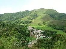
Lin Ma Hang (Chinese: 蓮麻坑) is a village in the Sha Tau Kok area of Hong Kong and is situated north of the New Territories, next to the Shenzhen river, east of Heung Yuen Wai and west of Hung Fa Leng.
| Lin Ma Hang | |||||||||
|---|---|---|---|---|---|---|---|---|---|
| Traditional Chinese | 蓮麻坑 | ||||||||
| Cantonese Yale | lìhn màh hāang | ||||||||
| |||||||||
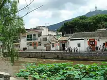
Until 4 January 2016, the village was situated in the Frontier Closed Area and was therefore inaccessible to non-permit holders. Since 4 January 2016, the village was excluded from the Frontier Closed Area. Nonetheless, a portion of Lin Ma Hang Road, the access road to the village still falls within the closed area. Therefore, permits are still required for anyone who visiting the village by road.
Administration
Lin Ma Hang is one of the villages represented within the Ta Kwu Ling District Rural Committee. For electoral purposes, Lin Ma Hang is part of the Sha Ta constituency, which is currently represented by Ko Wai-kei.[1][2]
History
People originated in the village are the Yip (葉) (or Ip, Yap, Yapp), Lau (劉), Sin (冼) and Koon (官) (or Kwun). It is named after a fruit called Lin Ma (蓮麻) that can be found in the mid-level streams.
Lin Ma Hang is part of the Four Yeuk (四約; 'Four Villages Alliance'), which comprises Loi Tung, Lung Yeuk Tau, Lin Ma Hang and Tan Chuk Hang. The centre of the Alliance is the Hung Shing Temple at Hung Leng.[3]
A lead mine was in operation in Lin Ma Hang starting in 1915.[4] Pb–Zn ore was mined there. The mine operated intermittently between 1915 and 1958, producing 16,000 tonnes of lead metal and 360,000 ounces of silver.[5] The Government rescinded the mining lease in 1962 and the mine was abandoned the same year.[4]
Fauna and flora
The abandoned lead mine now holds one of the most important bat colonies in Hong Kong, and was designated as a Site of Special Scientific Interest (SSSI) in 1994.[6][7]
The Lin Ma Hang Stream was designated as a SSSI in 2008.[8] It supports 17 species of primary freshwater fish, representing 50% of all such species native to Hong Kong.[9]
The village is situated in the basin of the Robin's Nest (Chinese: 紅花嶺) which is famous for its abundance in "Hanging Bell Flowers" (吊鐘花).
Built heritage
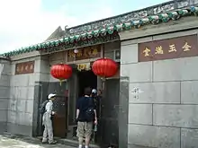
- The Residence of Ip Ting-sz is a declared monument[10]
- Old Bridge, Grade 3 historic building
- Ip Ancestral Hall, Grade 3 historic building
- Koon Ancestral Hall, Grade 3 historic building
- Kwan Tai Temple, not graded
- Lau Ancestral Hall, not graded
References
- "Recommended District Council Constituency Areas (North District)" (PDF). Electoral Affairs Commission. Retrieved 7 November 2021.
- "North District Council - North DC Members". District Council. Retrieved 7 November 2021.
- Antiquities Advisory Board. Historic Building Appraisal. Hung Shing Temple, Hung Leng Tsuen
- The Institute of Materials, Minerals and Mining Hong Kong Branch Archived 2008-11-20 at the Wayback Machine
- "Civil Engineering and Development Department: Economic Geology - Metalliferous minerals". Archived from the original on 2013-12-19. Retrieved 2009-10-22.
- Green Power: Lin Ma Hang lead mine, Hong Kong bat sanctuary
- "Agriculture, Fisheries and Conservation Department: Lin Ma Hang Lead Mine (Lower Cave)". Archived from the original on 2011-07-23. Retrieved 2009-10-22.
- Agriculture, Fisheries and Conservation Department Report 2007-2008
- Planning Department: Land Use Planning for the Closed Area – Development Potential & Constraints
- Antiquities and Monuments Office: Residence of Ip Ting-sz
External links
 |
Wikimedia Commons has media related to Lin Ma Hang. |