Miodet
The Miodet is a 30.4-kilometre (18.9 mi) stream in the Auvergne region.[1] It originates in the Livradois and joins the Dore (left bank), whereby it is a sub-affluent of the Loire.
| Miodet | |
|---|---|
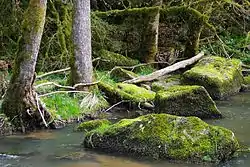 Before the Sauviat dam | |
| Physical characteristics | |
| Length | 30.4 km (18.9 mi) |
| Basin features | |
| Progression | Dore→ Allier→ Loire→ Atlantic Ocean |
Geography
The Miodet originates at 1,000 metres (3,300 ft) above sea level, at Saint-Éloy-la-Glacière, near the Bois de Mauchet, elevation 1,095 metres (3,593 ft). It runs almost entirely through wooded areas. It first runs south, before turning north-west at le sommet du Grun du Bois, elevation 896 metres (2,940 ft). It is joined by le ruisseau des Martinanches at Saint-Dier-d'Auvergne, then veers north-east. It runs north shortly before its confluence with the Dore on the left bank.
It is located in the Livradois-Forez Regional Natural Park.[2]
Communes
The course of the steam runs by or through :
References
- Sandre. "Fiche cours d'eau - Le Miodet (K29-0300)".
- "Situation". Parc naturel régional Livradois-Forez. Retrieved 26 November 2021.