Narsingdi District
Narsingdi District (Bengali: নরসিংদী জেলা) is a district in central Bangladesh. It is located 50 km north-east of Dhaka, capital city of Bangladesh. It is a part of the Dhaka Division.[1] The district is famous for its textile craft industry. Narsingdi is bordered by Kishoreganj in the north and north-east, Brahmanbaria in the east and south-east, Comilla in the south and south-east, Narayanganj in the south and south-west and Gazipur in the west.
Narsingdi
নরসিংদী | |
|---|---|
.jpg.webp) Swamp in Narsingdi | |
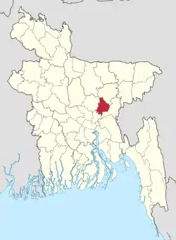 Location of Narsingdi District in Bangladesh | |
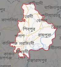
Expandable map of Narsingdi District | |
| Coordinates: 23.92°N 90.73°E | |
| Country |  Bangladesh Bangladesh |
| Division | Dhaka Division |
| Government | |
| • Deputy Commissioner | Syeda Farhana Kawnine |
| Area | |
| • Total | 1,140.76 km2 (440.45 sq mi) |
| Population (2011 census) | |
| • Total | 2,224,944 |
| • Density | 2,000/km2 (5,100/sq mi) |
| Time zone | UTC+06:00 (BST) |
| Postal code | 1600 |
| Website | Official website |
Subdivisions
There are six upazilas, or subdivisions, in the Narsingdi district.
Demographics
At the 2011 census, the population was 2,224,944. 94.33% were Muslims, 5.65% Hindus.
Rivers
The Meghna, the Shitalakshya, the old Brahmaputra, Arial Kha, Haridhoa, and Paharea are some of the main rivers that flow through this district.
Gallery
.jpg.webp)
.jpg.webp)
.jpg.webp)
.jpg.webp)
See also
References
- Md. Mosharraf Hossain Sarkar (2012). "Narsingdi District". In Sirajul Islam and Ahmed A. Jamal (ed.). Banglapedia: National Encyclopedia of Bangladesh (Second ed.). Asiatic Society of Bangladesh.
- "Bangladesh Population & Housing Census 2011" (PDF). Retrieved 6 July 2021.
External links
 |
Wikimedia Commons has media related to Narsingdi District. |
Capital: Narsingdi | ||
| Upazilas | | |
| Constituencies | ||
| Sites and attractions | ||
| Inhabited areas | ||
| Education | ||
| Rivers | ||
| Transport |
| |
| See also | ||
Authority control  | |
|---|---|
| General | |
| National libraries | |
| Other | |
This article is issued from Wikipedia. The text is licensed under Creative Commons - Attribution - Sharealike. Additional terms may apply for the media files.