Nelson Mandela Bay Metropolitan Municipality
Nelson Mandela Bay Municipality (Afrikaans: Nelson Mandelabaai Metropolitaanse Munisipaliteit; Xhosa: uMasipala wase Nelson Mandela Bay or uMasipala waseBhayi) is one of eight metropolitan municipalities (also called Category A municipalities) in South Africa. It is located on the shores of Algoa Bay in the Eastern Cape Province and comprises the city of Gqeberha, the nearby towns of Uitenhage and Despatch, and the surrounding rural area.
Nelson Mandela Bay | |
|---|---|
 Seal | |
.svg.png.webp) Location in the Eastern Cape | |
| Coordinates: 33°57′S 25°36′E | |
| Country | South Africa |
| Province | Eastern Cape |
| Seat | Gqeberha |
| Wards | 60 |
| Government | |
| • Type | Municipal council |
| • Mayor | Eugene Johnson (ANC) |
| Area | |
| • Total | 1,959 km2 (756 sq mi) |
| Population (2011)[1] | |
| • Total | 1,152,115 |
| • Density | 590/km2 (1,500/sq mi) |
| Racial makeup (2011) | |
| • Black African | 60.1% |
| • Coloured | 23.6% |
| • Indian/Asian | 1.1% |
| • White | 14.4% |
| First languages (2011) | |
| • Xhosa | 53.9% |
| • Afrikaans | 29.3% |
| • English | 13.5% |
| • Other | 3.3% |
| Time zone | UTC+2 (SAST) |
| Municipal code | NMA |
The name "Nelson Mandela Bay Municipality" was chosen to honour former President Nelson Mandela.
History
In 2001, the Nelson Mandela Bay Metropolitan Municipality was formed as an administrative area covering Gqeberha (Port Elizabeth), the neighbouring towns of Uitenhage and Despatch and the surrounding agricultural areas.
Demographics and statistics
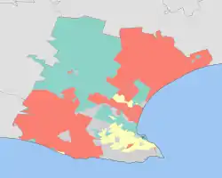
As of the census of 2001,[2] there are 1,005,776 people and 260,798 households in the Nelson Mandela Bay Metropolitan Municipality. The official estimate of population in 2007 was 1,050,930.
In the 2007 census, 60.4% of respondents described themselves as Black African, 22.6% Coloured, 16.1% White and 0.9% Indian/Asian.
The largest religious groupings are Christian (89.4% of residents), no religion (6.1%), Muslim (1.5%), Jewish (0.4%) and Hindu (0.3%).
57.3% of the residents speak Xhosa as their mother tongue. Afrikaans is the mother tongue of 29.7%, and English, 12.1%.
- 16.0% of all households are single-person.
- The average household size is 3.86.
- The median age is 26 years.
- For every 100 females there are 91.2 males.
- 28.2% of the population aged 15–65 is unemployed.
- The median annual income of working adults aged 15–65 is ZAR 21 837 ($3,282).
According to the 2009 edition of the municipality's 2006–2011 Integrated Development Plan, manufacturing is the single largest contributor to the local economy (33%), followed by community services (27%). Tourism represents a key sector of the economy that has increasingly contributed to job creation in recent years, thanks in large part to the municipality's seaside location and its abundance of unspoiled beaches, of which four carry Blue Flag status.[3]
100% of households have access to a source of water within a 200 m radius. 91% of households have access to a basic level of sanitation. 100% of households within the urban boundary have access to a basic level of solid waste removal, and 97% of households in formally demarcated municipal residential areas have access to a basic level of electricity. The municipality has 41 permanent and satellite clinics, 13 mobile clinics, eight hospitals, 22 libraries, 31 community and municipal halls, 79 sports facilities, 19 beaches, 18 pools, 273 schools, one university (the Nelson Mandela University), four technical colleges and two Further Education and Training institutions.[3]
Main places
The 2001 census divided the municipality into the following main places:[4]
| Place | Code | Area (km2) | Population | Most spoken language |
|---|---|---|---|---|
| Beachview | 27501 | 0.78 | 500 | Afrikaans |
| Bethelsdorp | 27502 | 77.64 | 134,617 | Afrikaans |
| Blue Horizon Bay | 27503 | 2.74 | 409 | Afrikaans |
| Cannonvale | 27504 | 0.69 | 196 | Afrikaans |
| Colchester | 27505 | 1.28 | 743 | Afrikaans |
| Despatch | 27506 | 38.75 | 25,086 | Afrikaans |
| Gqeberha | 27507 | 1.90 | 16,686 | Xhosa |
| Ibhayi | 27508 | 23.69 | 255,826 | Xhosa |
| Kabah | 27509 | 1.68 | 3,282 | Afrikaans |
| Khaya Mnandi | 27510 | 0.82 | 5,379 | Xhosa |
| KwaLanga | 27511 | 0.70 | 8,196 | Xhosa |
| KwaDwesi | 27512 | 5.10 | 17,733 | Xhosa |
| KwaNobuhle | 27513 | 15.34 | 87,585 | Xhosa |
| Motherwell | 27514 | 29.52 | 117,319 | Xhosa |
| Gqeberha (Port Elizabeth) | 27516 | 335.30 | 237,500 | Afrikaans |
| Seaview | 27517 | 1.60 | 732 | English |
| Uitenhage | 27518 | 84.77 | 71,666 | Afrikaans |
| Woodridge | 27519 | 0.56 | 270 | Xhosa |
| Young Park | 27520 | 0.52 | 762 | Afrikaans |
| Remainder of the municipality | 27515 | 1,328.77 | 21,281 | Xhosa |
Government
The municipal council consists of one hundred and twenty members elected by mixed-member proportional representation. Sixty councillors are elected by first-past-the-post voting in sixty wards, while the remaining sixty are chosen from party lists so that the total number of party representatives is proportional to the number of votes received. In the local government election of 1 November 2021, no party obtained a majority on the council again. The African National Congress managed to form a minority coalition government to govern the municipality. Former councillor and businesswoman Eugene Johnson of the ANC was elected mayor on 22 November 2021.[5]
The following table shows the results of the 2021 election.[6]
| Party | Ward | List | Total seats | |||||
|---|---|---|---|---|---|---|---|---|
| Votes | % | Seats | Votes | % | Seats | |||
| Democratic Alliance | 104,520 | 39.80 | 23 | 105,487 | 40.04 | 25 | 48 | |
| African National Congress | 103,104 | 39.26 | 37 | 104,339 | 39.60 | 11 | 48 | |
| Economic Freedom Fighters | 16,803 | 6.40 | 0 | 16,859 | 6.40 | 8 | 8 | |
| Northern Alliance | 5,726 | 2.18 | 0 | 5,499 | 2.09 | 3 | 3 | |
| African Christian Democratic Party | 4,317 | 1.64 | 0 | 4,427 | 1.68 | 2 | 2 | |
| Freedom Front Plus | 3,968 | 1.51 | 0 | 4,310 | 1.64 | 2 | 2 | |
| Defenders of the People | 3,859 | 1.47 | 0 | 3,640 | 1.38 | 2 | 2 | |
| Patriotic Alliance | 3,724 | 1.42 | 0 | 3,473 | 1.32 | 2 | 2 | |
| Abantu Integrity Movement | 2,758 | 1.05 | 0 | 2,914 | 1.11 | 1 | 1 | |
| United Democratic Movement | 2,665 | 1.01 | 0 | 2,832 | 1.07 | 1 | 1 | |
| African Independent Congress | 990 | 0.38 | 0 | 1,798 | 0.68 | 1 | 1 | |
| Good | 1,485 | 0.57 | 0 | 1,286 | 0.49 | 1 | 1 | |
| Independent candidates | 2,720 | 1.04 | 0 | 0 | ||||
| Pan Africanist Congress of Azania | 1,260 | 0.48 | 0 | 1,347 | 0.51 | 1 | 1 | |
| 15 other parties | 4,703 | 1.79 | 0 | 5,250 | 1.99 | 0 | 0 | |
| Total | 262,602 | 100.00 | 60 | 263,461 | 100.00 | 60 | 120 | |
| Valid votes | 262,602 | 98.73 | 263,461 | 98.66 | ||||
| Invalid/blank votes | 3,370 | 1.27 | 3,584 | 1.34 | ||||
| Total votes | 265,972 | 100.00 | 267,045 | 100.00 | ||||
| Registered voters/turnout | 583,270 | 45.60 | 583,270 | 45.78 | ||||
See also
References
- "Statistics by place". Statistics South Africa. Retrieved 27 September 2015.
- "Census 2001 home page". Statistics South Africa. Archived from the original on 12 December 2005.
- "Integrated Development Plan 2006–2011 of the Nelson Mandela Bay Metropolitan Municipality, 8th edition". Nelson Mandela Bay Municipality. Archived from the original on 28 September 2015. Retrieved 17 October 2009.
- Lookup Tables – Statistics South Africa
- "ANC scrapes together Nelson Mandela Bay coalition and takes mayor's chair". SowetanLIVE. Retrieved 5 December 2021.
- "Election Result Table for LGE2021 — Nelson Mandela Bay". wikitable.frith.dev. Retrieved 5 December 2021.
External links
Municipalities of the Eastern Cape | |||||||||||||
|---|---|---|---|---|---|---|---|---|---|---|---|---|---|
| Metropolitan | .svg.png.webp) | ||||||||||||
| District and local |
| ||||||||||||
| |||||||||||||||||||||||||||
| |||||||||||||||||||||||||||
| |||||||||||||||||||||||||||
| |||||||||||||||||||||||||||
| |||||||||||||||||||||||||||
| |||||||||||||||||||||||||||
| |||||||||||||||||||||||||||
| |||||||||||||||||||||||||||


