Erpe (Spree)
| Erpe | |
|---|---|
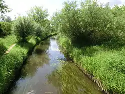 | |
 The Erpe (upper right to lower left) | |
| Native name | Neuenhagener Mühlenfließ |
| Location | |
| Country | Germany |
| State | Brandenburg |
| Physical characteristics | |
| Source | |
| • location | Werneuchen, Brandenburg |
| • coordinates | 52.6550545°N 13.7601816°E |
| • elevation | 77.5 m (254 ft) |
| Mouth | |
• location | Berlin-Köpenick |
• coordinates | 52.450278°N 13.594444°E |
• elevation | 32.3 m (106 ft) (45.2 m (148 ft) altitude difference) |
| Length | 31.8 km (19.8 miles) |
| Basin size | 216 km2 (83 sq mi) |
| Basin features | |
| Progression | Spree→ Havel→ Elbe→ North Sea |
| Tributaries | |
| • right | Zochegraben |
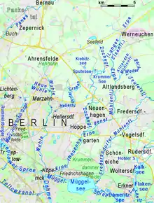
The Erpe is a tributary of Spree River in Brandenburg and Berlin, Germany. The upper third is also known als Langes Elsenfließ ("Long Lizzy-Flow"), the lower two thirds for about half a century were noted as Neuenhagener Mühlenfließ. Previously they had been one of several Mühlenfließe ("Mill Flow"s) without a specification. The course itself is quite natural, but it suffers pollution from a purification plant.

This article is issued from Wikipedia. The text is licensed under Creative Commons - Attribution - Sharealike. Additional terms may apply for the media files.