New Zealand outlying islands
The New Zealand outlying islands comprise nine offshore island groups, located in the subtropics and subantarctic, which are part of New Zealand but lie outside the territorial sea off its mainland coast (except the Solander Islands). Although considered to be integral parts of New Zealand, seven of the nine island groups are not part of any region or district, but are instead designated as Area Outside Territorial Authority. The two exceptions are the Chatham Islands, which form a special territorial authority (island council) themselves, and the Solander Islands, which are part of the Southland Region and Southland District.

Except the Kermadec Islands, all other eight island groups sit on the New Zealand continental shelf, which forms a part of Zealandia.[1]
The term is also used sometimes to further encompass the Balleny Islands, a group of sub-Antarctic islands technically considered a part of the Ross Dependency and covered by the Antarctic Treaty.
The five island groups of the New Zealand Subantarctic Islands, including their territorial seas, are a World Heritage Site.
Island groups
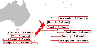
The outlying island groups from north to south:
| Map showing the major outlying islands of New Zealand | |||
 | |||
| Island group (alternate name) | Area (km2) | Highest peak (m) | Location of main island |
|---|---|---|---|
| North of the North Island | |||
| Kermadec Islands (Rangitāhua)[2] | 33.60 | Moumoukai Peak (516) | 29°16′S 177°55′W |
| Three Kings Islands (Manawatāwhi, Ngā Motu Karaka)[3] | 6.85 | (Great Island) (295) | 34°09′S 172°08′E |
| East of the South Island | |||
| Chatham Islands (Rēkohu, Wharekauri) | 966.00 | (Chatham Island) (299) | 43°54′S 176°32′W |
| South of the South Island | |||
| Solander Islands (Hautere)[4] | 1.20 | (Solander Island) (330) | 46°34′S 166°53′E |
| New Zealand Subantarctic Islands | |||
| Bounty Islands[5] | 1.35 | (Funnel Island) (73) | 47°46′S 179°02′E |
| Snares Islands (Tini Heke)[6] | 3.50 | (North East Island) (130) | 48°01′S 166°32′E |
| Antipodes Islands[7] | 21.00 | Mount Galloway (366) | 49°41′S 178°48′E |
| Auckland Islands (Motu Maha, Maungahuka)[8] | 625.64 | Mount Dick (705) | 50°42′S 166°05′E |
| Campbell Islands (Motu Ihupuku)[9] | 113.31 | Mount Honey (558) | 52°32′S 169°09′E |
| Outlying islands | 1772.4 | Mount Dick (705) | |
Population
The islands are all uninhabited except the Chatham Islands.
There is a staffed meteorological station on Raoul Island of the Kermadec Islands. The meteorological station on Campbell Island has been unstaffed and automated since 1995. There was a meteorological station on the Auckland Islands from 1942 to 1945. The Three Kings Islands and the Auckland Islands were formerly inhabited. There have been failed settlement attempts on Raoul Island, the Antipodes Islands and the Auckland Islands. The Solander Islands have never been inhabited except by shipwrecked sailors or marooned stowaways (for the longest period, from 1808 to 1813 by five European stowaways).
See also
References
- New Zealand actually sits on a continent called Zealandia, it's just that most of it is under water
- "Data Table - Protected Areas - LINZ Data Service (recorded area 3359.9864 ha)". Land Information New Zealand. Retrieved 2019-08-27.
- "Data Table - Protected Areas - LINZ Data Service (recorded area 684.7281 ha)". Land Information New Zealand. Retrieved 2019-08-27.
- "Data Table - Protected Areas - LINZ Data Service (recorded area 120 ha)". Land Information New Zealand. Retrieved 2019-08-27.
- "Data Table - Protected Areas - LINZ Data Service (recorded area 135 ha)". Land Information New Zealand. Retrieved 2019-08-27.
- "Data Table - Protected Areas - LINZ Data Service (recorded area 350 ha)". Land Information New Zealand. Retrieved 2019-08-27.
- "Data Table - Protected Areas - LINZ Data Service (recorded area 2100 ha)". Land Information New Zealand. Retrieved 2019-08-27.
- "Data Table - Protected Areas - LINZ Data Service (recorded area 62564 ha)". Land Information New Zealand. Retrieved 2019-08-27.
- "Data Table - Protected Areas - LINZ Data Service (recorded area 11331 ha)". Land Information New Zealand. Retrieved 2019-08-27.
External links
| |||||||||||||||||||||||||||||||||||