Occluded front
In meteorology, an occluded front is a weather front formed during cyclogenesis. The classical view of an occluded front is that it initiates when a cold front overtakes a warm front, such that the warm air is separated (occluded) from the cyclone center at the surface. The point where the warm front becomes the occluded front is the triple point; a new area of low-pressure that develops at this point is a triple-point low. A more modern view of the formation process suggests that occluded fronts form directly during the wrap-up of the baroclinic zone during cyclogenesis, and then lengthen due to flow deformation and rotation around the cyclone.
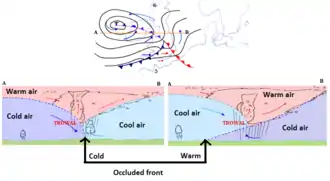
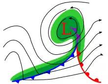
Occluded fronts usually form around mature low pressure areas. There are two types of occlusion, warm and cold:
In meteorology, an occluded front is a weather front formed during cyclogenesis. The classical view of an occluded front is that it initiates when a cold front overtakes a warm front, such that the warm air is separated (occluded) from the cyclone center at the surface. The point where the warm front becomes the occluded front is the triple point; a new area of low-pressure that develops at this point is a triple-point low. A more modern view of the formation process suggests that occluded fronts form directly during the wrap-up of the baroclinic zone during cyclogenesis, and then lengthen due to flow deformation and rotation around the cyclone.
- In a cold occlusion, the cold air mass that overtakes the warm air mass is cooler than the cooler air and plows under both air masses.
- In a warm occlusion, the cold air mass overtaking the warm front is hotter than the cool air following the warm air mass and rides over the colder air mass while lifting the warm air.
The occluded front symbol should locate where the cold air intersects the surface. It thus varies between warm and cold occlusions. The TROWAL on, the other hand, being the projection of the warm air trough aloft, is at the same position in both cases. The location of the occluded front on a surface weather analysis is often off track from the associated weather, which occurs at the TROWAL (short for TROugh of Warm air ALoft), the projection on the Earth's surface of the wedge of warm air above the surface.
Related weather
One symbol of an occluded front
TROWAL symbol with alternating blue and red lines similar to a cold/warm front junction
A cold front is diagramed as spikes. A warm front is shown as semi-circles in a traditional weather map. An occluded front is a combination of those two signs. They are indicated on a weather map either by a purple line with alternating semicircles and triangles pointing in direction of travel or by red semicircles and blue triangles pointing in the same direction. On the other hand, a TROWAL is diagramed by the junction of blue and red lines like the junction of cold and warm fronts aloft.
A wide variety of weather can be found along an occluded front, with thunderstorms possible, but usually, their passage is associated with a drying of the air mass. Additionally, cold core funnel clouds are possible if the shear is significant along the cold front. Small isolated occluded fronts often remain for a period after a low-pressure system has decayed and these create cloudy conditions with patchy rain or showers.
However, the clouds and precipitation are not really where the projection on the Earth's surface of the occluded front is, but with the trowal position.
See also
References
Schultz, D. M., and G. Vaughan, 2011: Occluded fronts and the occlusion process: A fresh look at conventional wisdom. Bull. Amer. Meteor. Soc., 92, 443–466, ES19–ES20.
External links
- A film clip AIR MASSES AND FRONTS - THE OCCLUDED FRONT (1962) is available at the Internet Archive
- Occluded Front.
Authority control  | |
|---|---|
| National libraries | |
| Other | |