Ogo Mountains
The Ogo Mountains, also known as the Galgodon Highlands,[1] (Somali: Buuraha Oogo, Arabic: جبل أوغو) are a mountain range in Somaliland. They cross the Sanaag and Togdheer regions. With a mean peak height of 2,450 m (8,040 ft), the ecology of this landform is semi-desert.
| Ogo Mountains Galgodon Highlands[1] Buuraha Oogo جَبَل أوغو | |
|---|---|
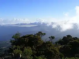 Cal Madow, a subrange of the Ogo Mountains | |
| Highest point | |
| Peak | Shimbiris |
| Elevation | 2,450 m (8,040 ft) |
| Coordinates | 10°44′03.3″N 47°13′56.6″E |
| Geography | |
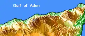 Map of the Ogo Mountains
| |
| Country |  Somaliland Somaliland |
| Regions | Sanaag and Togdheer |
Ecology
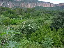
Due to the Ogo Mountains' elevated, highland location in Somaliland, the range has an unexpectedly temperate climate.[2] The mountains also catch the precipitation of the Indian Ocean's monsoon winds, resulting in a rainy season that lasts from June until mid-September.
Climate
The average annual temperature in the Ogo Mountains is 20 to 26 °C (68 to 79 °F). Precipitation reaches a maximum in March, with a minimum of rainfall in August. The average annual precipitation around 500–700 mm (20–28 in).[2]
The data provided below derives from the Gudaado station. It illustrates a subtropical highland climate with strong continental Meditterranean characteristics (Köppen: "Cwb"), given the two marked wet seasons that span between March-May and September-November, albeit the latter being briefer and more subtle. The climatic situation here is most similar to the Altiplano region, due to its semi-arid patterns of rain, huge diurnal temperature variations, adjacence to the Somali desert, and seasonal variations that are neither too cold nor too hot in the extremes.
| Climate data for Gudaado (10°44'03.3"N 47°13'56.6"E) (elev. 2239 metres above sea level) | |||||||||||||
|---|---|---|---|---|---|---|---|---|---|---|---|---|---|
| Month | Jan | Feb | Mar | Apr | May | Jun | Jul | Aug | Sep | Oct | Nov | Dec | Year |
| Average high °C (°F) | 22.6 (72.7) |
23.7 (74.7) |
24.1 (75.4) |
23.8 (74.8) |
24.6 (76.3) |
27.1 (80.8) |
27.1 (80.8) |
26.9 (80.4) |
26.4 (79.5) |
23.0 (73.4) |
22.3 (72.1) |
22.2 (72.0) |
24.5 (76.1) |
| Daily mean °C (°F) | 16.7 (62.1) |
17.8 (64.0) |
19.0 (66.2) |
19.6 (67.3) |
20.0 (68.0) |
22.0 (71.6) |
22.3 (72.1) |
22.1 (71.8) |
21.3 (70.3) |
18.1 (64.6) |
17.0 (62.6) |
16.4 (61.5) |
19.4 (66.8) |
| Average low °C (°F) | 11.7 (53.1) |
12.8 (55.0) |
14.3 (57.7) |
15.6 (60.1) |
16.1 (61.0) |
17.3 (63.1) |
17.8 (64.0) |
17.8 (64.0) |
17.1 (62.8) |
13.9 (57.0) |
12.5 (54.5) |
11.6 (52.9) |
14.9 (58.8) |
| Average rainfall mm (inches) | 9 (0.4) |
17 (0.7) |
58 (2.3) |
160 (6.3) |
140 (5.5) |
6 (0.2) |
1 (0.0) |
3 (0.1) |
22 (0.9) |
90 (3.5) |
35 (1.4) |
12 (0.5) |
553 (21.8) |
| Source: Climate Data[2] | |||||||||||||
See also
- Lamadaya waterfalls
References
- "Galgodon Highlands". Encyclopædia Britannica. Retrieved 25 June 2013.
- "Climate Guadaado, Somalia". Climate Data. Retrieved 9 April 2012.