Old Hickory Boulevard
Old Hickory Boulevard is a historic road that encircles Nashville, Tennessee. Originally the road, aided by ferries, formed a nearly unbroken loop around the city. Today, it is interrupted by a lake and rerouted sections.
    | |||
|---|---|---|---|
| Maintained by | TDOT | ||
| Component highways | |||
| Location | Nashville, Tennessee | ||
| Major junctions |
Incomplete loop around Nashville | ||
Route description
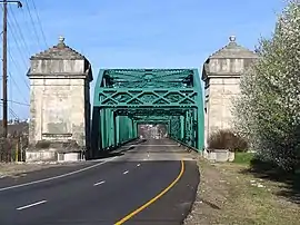
The road is named for President Andrew Jackson, who was nicknamed "Old Hickory." The road intersects with each of Interstates 24, 65, and 40 in the Nashville area at least twice, which contributes to the misconception that there are many roads in Nashville using this name, rather than one.
To the southeast, Old Hickory Boulevard was interrupted by the creation of Percy Priest Lake and is now partly underwater. The gap created by the lake effectively merged the identity of Old Hickory Boulevard with Bell Road, But the two are distinct; traffic continues from Old Hickory Boulevard straight onto Bell Road at an intersection about 0.6 miles (0.97 km) east of Nolensville Pike (US 31A/US 41A) while Old Hickory Boulevard itself turns right at the intersection toward I-24. From there, it proceeds north-northeast to intersect Murfreesboro Pike (US 41/US 70), and merging with Lavergne-Couchville Pike 1.0 mile (1.6 km) later, near where the old route of the road enters what is now the lake.[1]
On the west side, it terminates at River Road Pike and Old Charlotte Pike, north of Bellevue and south of the Cumberland River. A previous segment about 2 miles (3.2 km) to the northeast runs from Charlotte Pike (US 70) to the former Cleeces Ferry location on the south bank of the Cumberland River; this was renamed Annex Avenue after the ferry closed. Old Hickory Boulevard south of U.S. 70 and the section renamed Annex Avenue never aligned.
On the north side of the river, Old Hickory Boulevard terminates at the former ferry ramp, which is now a boat launch.
Along its path, Old Hickory Boulevard is part of several state routes: SR 171, SR 254, SR 251, and SR 45.
History
Old Hickory Boulevard formerly formed a complete loop around the city of Nashville. The creation of Percy Priest Lake sunk the southeast portion of the highway. Major road projects combined with the gap created by the lake effectively merged the identity of Old Hickory Boulevard with Bell Road, But the two are distinct; traffic continues from Old Hickory Boulevard straight onto Bell Road. One of the ferries used on the road, Cleeces Ferry, closed in 1990 after the opening of the Andrew B. Gibson Bridge on Tennessee State Route 155, which is also known as Briley Parkway.
Major junctions
Northern segment
| County | Location | mi | km | Destinations | Notes |
|---|---|---|---|---|---|
| Davidson | Nashville | Former site of Cleece's Ferry | Western terminus of northern segment | ||
 SR 12 SR 12 | |||||
 US 41A US 41A | |||||
| Whites Creek |  US 431 US 431 | Western end of SR 45 | |||
| Nashville |  I-24 I-24 | I-24 exit 40 | |||
| Brick Church Pike | |||||
  US 31W / US 41 / Dickerson Pike US 31W / US 41 / Dickerson Pike | |||||
 I-65 I-65 | I-65 exit 92 | ||||
 US 31E US 31E | Old Hickory splits from SR 45; continues south on US 31E | ||||
| E Old Hickory Blvd | Old Hickory splits from US 31E; continues east | ||||
| SR 45 | Old Hickory remerges with SR 45 | ||||
| Lebanon |  US 70 US 70 | Northern end of SR 265 | |||
| Hermitage |  I-40 I-40 | I-40 exit 221; southern end of SR 45 | |||
| Bell Road | |||||
| Percy Priest Lake | Eastern terminus of northern segment; road sunken by Percy Priest Lake | ||||
1.000 mi = 1.609 km; 1.000 km = 0.621 mi
| |||||
References
- "Google Maps route following Old Hickory Boulevard". Google. Retrieved July 19, 2020.