Pahasapa Formation
The Pahasapa Formation is a geological unit of primarily limestone and dolostone[3] that is exposed primarily in the Black Hills of South Dakota. Analogous to the Madison Limestone and the Burlington Limestone,[4] other Mississippian-aged limestones in the midwestern United States.
| Pahasapa Formation Stratigraphic range: Mississippian[1] | |
|---|---|
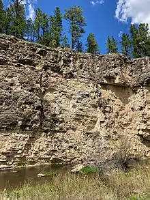 An exposure of the cliff forming Pahasapa west of Rapid City, along Nemo Road. The karstic tendencies of the unit are clearly visible in the pitting of the face. | |
| Type | Formation |
| Underlies | Minnelusa Formation[2] |
| Overlies | Englewood Formation[2] |
| Thickness | 225-500 ft[1] |
| Lithology | |
| Primary | Limestone |
| Other | Dolostone, dolomitic limestone |
| Location | |
| Region | South Dakota |
| Country | United States |
| Type section | |
| Named for | the Dakota people's name for the Black Hills[1] |
See also
 Earth sciences portal
 Paleontology portal
Citations
- Darton, N.H. (1901). "Preliminary description of the geology and water resources of the southern half of the Black Hills and adjoining regions in South Dakota and Wyoming" (PDF). U.S. Geological Survey Annual Report. 21 (pt. 4): 489. Retrieved 11 June 2021.
- Feldman, R.M.; Heimlich, R.A. (1980). The Black Hills Field Guide. Dubuque: Kendell/Hunt Publishing Co. p. 190.
- Butler, R.J.; Battin, R.L.; Winston, G.O. (1955). "Lithologic correlation of middle and lower Paleozoic rocks". North Dakota Geological Society Field Conference Guidebook. 3: 38–42.
- Darton, N.H. and Paige, Sidney (1925). Central Black Hills folio, South Dakota (Map). 1:125,000. Geologic Atlas of the United States. United States Geological Survey. p. GF-219.CS1 maint: multiple names: authors list (link)
This article is issued from Wikipedia. The text is licensed under Creative Commons - Attribution - Sharealike. Additional terms may apply for the media files.