Planning regions of Latvia
There are five planning regions of Latvia (Latvian: Latvijas plānošanas reģioni); Kurzeme, Latgale, Riga, Vidzeme and Zemgale. The boundaries of the regions aligns to the boundaries of the municipalities of Latvia following the municipality reform of 1 July 2009. The planning regions of Latvia are not administrative territorial divisions, since they are not mentioned in the law that prescribes the administrative territorial divisions of Latvia.[1]
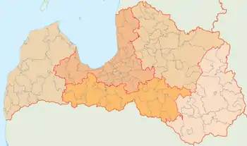
List
| Regions | Largest city | Area | Population - (per km2) |
|---|---|---|---|
| Riga | Riga | 10,132 km2 | 1,030,071 - (101.7/km2) |
| Kurzeme | Liepāja | 13,596 km2 | 301,621 - (22.2/km2) |
| Latgale | Daugavpils | 14,549 km2 | 304,032 - (20.9/km2) |
| Zemgale | Jelgava | 10,733 km2 | 254,461 - (23.7/km2) |
| Vidzeme | Valmiera | 15,246 km2 | 211,309 - (13.9/km2) |
| Latvia | Riga | 64,256 km² | 2,070,371 - (32.2/km²) |
History
Regional institutions began formation 1997 according to municipal initiatives on the planning of common development. Following legislation on regional development, the five planning regions were created according to the 5 May 2009 decision no. 391 of the Latvian Cabinet of Ministers: "Decisions on Territories of the Planning Regions.[2][3]
References
- "Administratīvo teritoriju un apdzīvoto vietu likums" (in Latvian). likumi.lv. 2008-12-08. Retrieved 2010-01-10.
- "Plānošanas reģioni" (in Latvian). Ministry of Regional Development and Local-governments. Retrieved 2010-01-10.
- "Noteikumi par plānošanas reģionu teritorijām" (in Latvian). Cabinet of Ministers of Latvia. 2009-05-05. Retrieved 2010-01-10.