Regions of Tajikistan
Tajikistan is divided into
- one autonomous region (Tajik: Вилояти мухтор, viloyati mukhtor)
- two regions (Tajik: вилоятҳо, viloyatho Persian: ولایتها), sing. Tajik: вилоят, viloyatو Persian: ولایت, Russian: oblast )
- the Districts of Republican Subordination
- the capital city, Dushanbe.
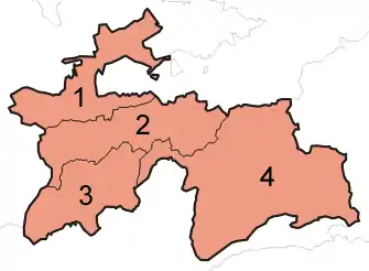
A clickable map of Tajikistan exhibiting its four provinces.
| No. | Name | Tajik | ISO | Capital | Area {km2) | Pop (2000) | Pop (2010)[1] | Pop (2019)[2] |
|---|---|---|---|---|---|---|---|---|
| 1 | Sughd Region | Вилояти Суғд Viloyati Sughd | TJ-SU | Khujand | 25,400 | 1,871,979 | 2,233,550 | 2,658,400 |
| 2 | Districts of Republican Subordination | Ноҳияҳои тобеи ҷумҳурӣ Nohiyahoi tobei jumhurī | - | Dushanbe | 28,600 | 1,337,479 | 1,722,908 | 2,120,000 |
| 3 | Khatlon Region | Вилояти Хатлон Viloyati Khatlon | TJ-KT | Bokhtar | 24,800 | 2,150,136 | 2,677,251 | 3,274,900 |
| 4 | Gorno-Badakhshan Autonomous Region1 | Вилояти Мухтори Кӯҳистони Бадахшон Viloyati Mukhtori Kūhistoni Badakhshon | TJ-GB | Khorugh | 64,200 | 206,004 | 205,949 | 226,900 |
| – | Dushanbe | Душанбе Dushanbe | – | Dushanbe | 124.6 | 561,895 | 724,844 | 846,400 |
 |
|---|
|
|
 Tajikistan portal Tajikistan portal |

1 The direct translation from Tajik is Kuhistoni Badakhshon Autonoumous Region, but the name translated from Russian is more commonly used in English.
Each region is divided into districts (nohiya or rayon), which are further subdivided into jamoats (full name jamoati dehot), and then villages/settlements (deha). Tajikistan has a total of 58 (not including 4 districts of the capital city Dushanbe) districts.
See also
References and footnotes
- "Changes in the number and distribution of the population of the Republic of Tajikistan between the censuses of 2000 and 2010" (PDF) (in Russian). Tajstat. Archived from the original (PDF) on 2014-01-04. Retrieved 12 September 2014.
- "Tajikistan: Provinces and Major Cities". City Population. Retrieved 1 February 2020.
This article is issued from Wikipedia. The text is licensed under Creative Commons - Attribution - Sharealike. Additional terms may apply for the media files.