Rhode Island Route 122
Route 122 is a numbered state highway running 14.2 miles (22.9 km) in Rhode Island, United States. Its southern terminus is at U.S. Route 1 (US 1) in Pawtucket, and its northern terminus is at the Massachusetts border where it continues as Massachusetts Route 122.
 | ||||
|---|---|---|---|---|
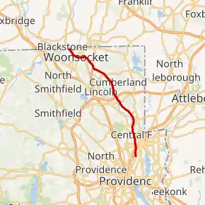
Route 122 highlighted in red | ||||
| Route information | ||||
| Maintained by RIDOT | ||||
| Length | 14.2 mi[1] (22.9 km) | |||
| Major junctions | ||||
| South end |  US 1 in Pawtucket US 1 in Pawtucket | |||
 I-95 in Pawtucket I-95 in Pawtucket
 Route 114 in Woonsocket Route 114 in Woonsocket | ||||
| North end |  Route 122 in Blackstone, MA Route 122 in Blackstone, MA | |||
| Location | ||||
| Counties | Providence | |||
| Highway system | ||||
Rhode Island Routes
| ||||

Route description
Route 122 takes the following route through the State:
- Pawtucket: 1.6 miles (2.6 km); U.S. 1 to Central Falls city line
- Main Street and Lonsdale Avenue
- Central Falls: 0.9 miles (1.4 km); Pawtucket city line to Lincoln town line
- Lonsdale Avenue
- Lincoln: 1.0 mile (1.6 km); Central Falls city line to Cumberland town line
- Lonsdale Avenue
- Cumberland: 6.9 miles (11.1 km); Lincoln town line to Woonsocket city line
- Mendon Road
- Woonsocket: 3.8 miles (6.1 km); Cumberland town line to Massachusetts State line at Route 122
- Mendon Road, Cumberland Hill Road, Hamlet Avenue, Court Street, [High Street] (Main Street, Arnold Street), Arnold Street, Railroad Street and Harris Avenue
History
Route 122 used to extend south along US 1 into Providence then along Randall Street to end at Charles Street (present-day Route 246).
Major intersections
The entire route is in Providence County.
| Location | mi[1] | km | Destinations | Notes | |
|---|---|---|---|---|---|
| Pawtucket | 0.0 | 0.0 | US 1 (Main Street) | Southern terminus | |
| 1.0 | 1.6 | I-95 south – Providence, Warwick | Exit 26 on I-95, northbound exit and southbound entrance from I-95 | ||
| 1.1 | 1.8 |  Route 15 (Mineral Spring Avenue) Route 15 (Mineral Spring Avenue) | |||
| Lincoln | 3.5 | 5.6 |  Route 123 (John Street) Route 123 (John Street) | ||
| Cumberland | 6.1 | 9.8 |  Route 116 east (Angell Road) Route 116 east (Angell Road) | Southern terminus of concurrency with Route 116 | |
| 6.3 | 10.1 | Route 116 west (George Washington Highway) | Northern terminus of concurrency with Route 116 | ||
| 6.8 | 10.9 |     I-295 to I-95 / Route 146 – Johnston, Attleboro, MA I-295 to I-95 / Route 146 – Johnston, Attleboro, MA | Exit 20 on I-295 | ||
| Cumberland Hill | 9.3 | 15.0 |  Route 120 east (Nate Whipple Highway) Route 120 east (Nate Whipple Highway) | Western terminus of Route 120 | |
| Cumberland Hill–Woonsocket line | 10.6 | 17.1 |  Route 99 south to I-295 / Route 146 Route 99 south to I-295 / Route 146 | Interchange, northern terminus of Route 99 | |
| Woonsocket | 12.1 | 19.5 |  Route 126 south (Hamlet Ave) Route 126 south (Hamlet Ave) | Southern terminus of concurrency with Route 126 | |
| 12.4 | 20.0 | Route 126 south (Manville Road) | Northern terminus of concurrency with Route 126 | ||
| 13.0 | 20.9 |  Route 104 north Route 104 north | Southern terminus of southbound concurrency with Route 104 | ||
| 13.0 | 20.9 | Route 104 north | Northern terminus of southbound concurrency with Route 104 | ||
| 13.8 | 22.2 | Route 114 south (Winter Street) | Northern terminus of Route 114 | ||
| 14.2 | 22.9 | Route 122 north – Worcester | Continuation into Massachusetts | ||
1.000 mi = 1.609 km; 1.000 km = 0.621 mi
| |||||
References
- Google (December 30, 2013). "Route 122" (Map). Google Maps. Google. Retrieved December 30, 2013.
 Rhode Island portal
External links
This article is issued from Wikipedia. The text is licensed under Creative Commons - Attribution - Sharealike. Additional terms may apply for the media files.