Rhode Island Route 81
Route 81 is a numbered state highway running 8.0 miles (12.9 km) in Rhode Island. Route 81's southern terminus is at Rhode Island Route 179 in Little Compton and the northern terminus is a continuation as Massachusetts Route 81 near Fall River, Massachusetts.
 | ||||
|---|---|---|---|---|
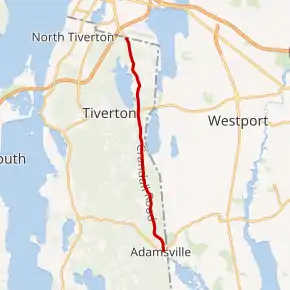
Route 81 highlighted in red | ||||
| Route information | ||||
| Maintained by RIDOT | ||||
| Length | 8.0 mi[1] (12.9 km) | |||
| Major junctions | ||||
| South end |  Route 179 in Little Compton Route 179 in Little Compton | |||
 Route 177 in Tiverton Route 177 in Tiverton | ||||
| North end |  Route 81 in Fall River, MA Route 81 in Fall River, MA | |||
| Location | ||||
| Counties | Newport | |||
| Highway system | ||||
Rhode Island Routes
| ||||


Route description
Route 81 takes the following route through the State:
- Little Compton: 0.5 miles (0.80 km): Route 179 to Tiverton town line
- Crandall Road
- Tiverton: 7.3 miles (11.7 km); Little Compton town line to Massachusetts state line at Route 81
- Crandall Road, Stafford Road and William S. Canning Boulevard
Major intersections
The entire route is in Newport County.
| Location | mi[1] | km | Destinations | Notes | |
|---|---|---|---|---|---|
| Little Compton | 0.0 | 0.0 | Route 179 west (Main Street) | Southern terminus; eastern end of Route 179 | |
| Tiverton | 5.2 | 8.4 | Route 177 (Bulgarmarsh Road) | ||
| 8.0 | 12.9 | Route 81 north – Fall River | Continuation into Massachusetts | ||
| 1.000 mi = 1.609 km; 1.000 km = 0.621 mi | |||||
See also
References
- Google (December 25, 2013). "Route 81" (Map). Google Maps. Google. Retrieved December 25, 2013.
External links
This article is issued from Wikipedia. The text is licensed under Creative Commons - Attribution - Sharealike. Additional terms may apply for the media files.