Tambroso
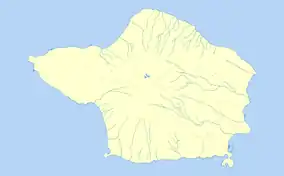
Tambroso is a peak on the island of Faial in the Azores. It is located in the civil parish of Ribeirinha, in the municipality of Horta.
| Tambroso | |
|---|---|
  Tambroso | |
| Highest point | |
| Elevation | 497 m (1,631 ft) |
| Prominence | Alto da Pedreira |
| Coordinates | 38°35′59.99″N 28°39′0″W |
| Naming | |
| Language of name | Portuguese |
| Geography | |
| Parent range | Cabeço Gordo |
The mountain, and its surrounding land-forms, is geographically close to the volcanic caldera at the center of Faial. The rim of this caldera forms the base of Tambroso, and many other local peaks.[1] The whole system has a maximum elevation at Cabeço Gordo, which is 1,043 metres (3,422 ft) above sea level.
Tambroso itself reaches 506 metres (1,660 ft) above sea-level. [1] It is situated near Alto da Pedreira, another local peak, and the town of Ribeirinha.[1]

References
Notes
- Mapa dos Açores, Série Regional (in Portuguese) (5 ed.), Freytag-Berndt u. Artaria KG, ISBN 978-989-556-071-4
Sources
- SRAM, ed. (2016), Environmental Regions of the Azores, Horta (Azores), Portugal: Secretaria Regional do Ambiente e do Mar/Governo Regional dos Açores, ISBN 972-9171-12-2
This article is issued from Wikipedia. The text is licensed under Creative Commons - Attribution - Sharealike. Additional terms may apply for the media files.