Tana Toraja Regency
Tana Toraja Regency (Indonesian for Torajaland or Land of the Toraja, abbreviated Tator; Indonesian pronunciation: [ˈtana toˈrad͡ʒa]) is a landlocked regency (kabupaten) of South Sulawesi Province of Indonesia, and home to the Toraja ethnic group. It covers an area of 2,054.30 km2 and had a population of 221,081 at the 2010 Census and 280,794 at the 2020 Census.[2] The local government seat is in Makale, while the center of Toraja culture is in Rantepao. Formerly, the Tana Toraja area covered a larger area, but in 2008 this was divided into two regencies, consisting of Tana Toraja with its capital at Makale and Toraja Utara (North Toraja) with its capital at Rantepao.
Tana Toraja Regency
Kabupaten Tana Toraja | |
|---|---|
 Seal | |
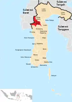 Location within South Sulawesi | |
| Country | Indonesia |
| Province | South Sulawesi |
| Anniversary | 1 September 1247 |
| Capital | Makale |
| Area | |
| • Total | 2,054.30 km2 (793.17 sq mi) |
| Population (2020 Census)[1] | |
| • Total | 280,794 |
| • Density | 140/km2 (350/sq mi) |
| Time zone | UTC+8 (WITA) |
The Tana Toraja boundary was determined by the Dutch East Indies government in 1909. In 1926, Tana Toraja was under the administration of Bugis state, Luwu. The regentschap (or regency) status was given on 8 October 1946, the last regency given by the Dutch. Since 1984, Tana Toraja has been named as the second tourist destination after Bali by the Ministry of Tourism, Indonesia. Since then, hundreds of thousands of foreign visitors have visited this regency. In addition, numerous Western anthropologists have come to Tana Toraja to study the indigenous culture and people of Toraja.
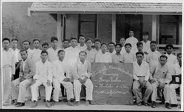
picture credits : Tropenmuseum.
Geography
Tana Toraja is centrally placed in the island of Sulawesi, 300 km north of Makassar, the provincial capital of South Sulawesi. It lies between latitude of 2°-3° South and longitude 119°-120° East (center: 3°S 120°E). The total area (since the separation of the new regency of North Toraja) is 2,054.30 km², about 4.4% of the total area of South Sulawesi province. The topography of Tana Toraja is mountainous; its minimum elevation is 150 m, while the maximum is 3,083 above the sea level.[3]
Administrative Districts
Tana Toraja Regency in 2020 comprised nineteen administrative Districts (Kecamatan), tabulated below with their areas and their populations at the 2010 Census[4] and the 2020 Census.[5] The table also includes the administrative centre of the district, the numbers of administrative villages (kelurahan and desa) within that district, and its post code.
| Name | Area in km2 | Population Census 2010 | Population Census 2020 | Administrative centre | Number of villages | Post code |
|---|---|---|---|---|---|---|
| Bonggakaradeng | 206.76 | 6,668 | 8,023 | Ratte Buttu | 6 | 91872 |
| Simbuang | 194.82 | 6,166 | 7,959 | Simbuang | 6 | 91874 |
| Rano | 89.43 | 6,042 | 7,649 | Rumandan | 5 | 91875 |
| Mappak | 166.02 | 5,509 | 7,018 | Kondo Dewata | 6 | 91873 |
| Mengkendek | 196.74 | 27,342 | 36,390 | Rante Kalua | 17 | 91870 |
| Gandang Batu Silanan | 108.63 | 19,238 | 23,049 | Benteng Ambeso | 12 | 91871 |
| Sangalla | 36.24 | 6,606 | 7,958 | Bulian Massabu | 5 | 91881 |
| Sangalla Selatan (South Sangalla) | 47.80 | 7,361 | 9,557 | Rante Alang | 5 | 91882 |
| Sangalla Utara (North Sangalla) | 27.96 | 7,327 | 9,041 | Tombang | 6 | 91883 |
| Makale | 39.75 | 33,631 | 38,814 | Bombangan | 15 | 91811 -91817 |
| Makale Selatan (South Makale) | 61.70 | 12,415 | 16,609 | Tiromanda | 8 | 91815 |
| Makale Utara (North Makale) | 26.08 | 11,799 | 14,602 | Lion Tondokiring | 5 | 91812 -91817 |
| Saluputti | 87.54 | 7,424 | 9,741 | Pattan Ulusalu | 9 | 91864 |
| Bittuang | 163.27 | 14,247 | 18,692 | Bittuang | 15 | 91896 |
| Rembon | 134.47 | 18,219 | 24,662 | Talion | 13 | 91860 |
| Masanda | 134.77 | 6,278 | 8,495 | Pondingao | 8 | 91894 |
| Malimbong Balepe | 211.47 | 8,923 | 10,517 | Malimbong | 6 | 91861 |
| Rantetayo | 60.35 | 10,737 | 14,614 | Padang Iring | 6 | 91863 |
| Kurra | 60.50 | 5,149 | 7,404 | Ratte Kurra | 6 | 91862 |
| Totals | 2,054.30 | 221,081 | 280,794 | Makale | 159 |
See also
 |
Wikimedia Commons has media related to Tana Toraja Regency. |
References
- Badan Pusat Statistik, Jakarta, 2021.
- Badan Pusat Statistik, Jakarta, 2021.
- "Official Tana Toraja website" (in Indonesian). Archived from the original on 2005-11-10.
- Biro Pusat Statistik, Jakarta, 2011.
- Badan Pusat Statistik, Jakarta, 2021.
External links
- Toraja Treasures.com - Toraja online information.
- Official website
 Tana Toraja travel guide from Wikivoyage
- Rural Tana Toraja Region: Photo Essay
Regencies and cities of South Sulawesi | ||
|---|---|---|
Capital: Makassar | ||
| Regencies |  | |
| Cities | ||
Authority control  | |
|---|---|
| General | |
| National libraries | |