Texas Gulf Coast
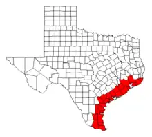
Texas Gulf Coast is an oceanic basin which boundaries the coastal region of Texas. Texas has approximately 3,359 miles (5,406 km) of shoreline which boundaries the Gulf of Mexico.[1]
Administrative Divisions
There are fourteen Texas counties which encompass the Gulf of Mexico coastal boundary;
| Aransas | Kenedy |
| Brazoria | Kleberg |
| Calhoun | Matagorda |
| Cameron | Nueces |
| Chambers | Refugio |
| Galveston | San Patricio |
| Jefferson | Willacy |
Topography
Gulf of Mexico Bays and Texas Coastal Inlets
The Texas gulf coast has a geography of eight coastal bays or inlets;
| Aransas Bay | Galveston Bay |
| Baffin Bay | Lavaca Bay |
| Copano Bay | Matagorda Bay |
| Corpus Christi Bay | San Antonio Bay |
National and State Parks of Texas Gulf Shores
The Texas Parks and Wildlife Department oversees the Texas state parks located on the Gulf of Mexico shores with the exception of Padre Island seashore which is maintained by the National Park Service.
| Galveston Island State Park | Padre Island National Seashore |
| Goose Island State Park | Resaca de la Palma State Park |
| Mustang Island State Park | Sea Rim State Park |
Nature and Wildlife Sanctuaries of Texas Coastal Region
The United States Fish and Wildlife Service governs the nature reserves as land parcels of the National Wildlife Refuge System bordering the Texas coastal shores.
History
European Colonization of Texas Coast
The Texas coastline was colonized by French king Louis XIV from 1684 to 1689. In 1685 while pursuing an expedition for New France, Robert Cavelier de La Salle moored near Matagorda Bay establishing the French colonization of Texas.[2]
The marginal sea coast acknowledged the arrival or entradas of Álvar Núñez Cabeza de Vaca, a Spanish conquistador of the New World and a successor of Christopher Columbus, who embarked on a calamitous coastal ship landing near the shore of Galveston Island on November 6, 1528.[3][4] The Texas Gulf coast attested to a second wave of the European colonization of the Americas with the introduction of colonialism by the Spanish Empire in 1690.
The España cultural evolution substantiated a christianization or religious conquest by the transatlantic crossing of the Spanish Inquisition.[5][6] The España colonization established the Viceroyalty of New Spain administratively structuring an interior province known as Spanish Texas from 1690 to 1821.[7][8] Beginning in 1810, the Mexican War of Independence was settled with the Spanish Empire ennobling a discontinuation of the Mexican Inquisition while creating the First Mexican Empire in 1821.
After the conflict ceased between Mexico and Spain, the Texas uncultivated lands acquired a successive uniformity known as Mexican Texas from 1821 to 1836.[9][10] Texas independence was expeditiously declared from imperial Mexico with the cessation of the Battle of San Jacinto, capture of Antonio López de Santa Anna, and the impending formation of the Republic of Texas.
Texas Gulf Coast and Mexican State Imperialism
The Texas Gulf Coast provided a naval supply lifeline for the Texian Army and Texian Militia during the Texas Revolution. The Texian Navy sustained the Texian revolutionary infantry forces by providing a flotilla for the safe passage of munitions and supply provisions from the maritime transport harbors of Mobile and New Orleans while contending with the Mexican state nautical hostilities on the Third Coast.
The Mexican Navy enforced coastline patrols and naval blockades of the Texas Gulf Coast harbors during the strife for Texas Declaration of Independence. The Texas naval forces appropriated four man-of-war schooners as a naval offensive for the sailing ship tactics of the Mexican Navy. The Texas Navy engaged four warships from 1835 to 1838 known as Brutus, Independence, Invincible, and Liberty for the establishment of the Republic of Texas and decisively the Texas annexation on December 29, 1845.
Infectious Disease Epidemic of 19th Century
In 1860s, the Texas gulf coastal counties encountered a disease vector consequently arriving in commerce and trade ports through merchant ships, nautical vessels, and seafaring ships on the Texas coastline.[11][12] The predatorial Aedes aegypti yield an arbovirus or mosquito-borne disease aggressively disseminating an infection known as yellow fever on the South Texas civil parishes.[13][14][15][16]
United States National Security of Texas Gulf Seacoast
The Texas Gulf coast had a vital necessity for seacoast defense as the international relations of superiority cultivated during the late 19th century to the mid-20th century. The United States artillery installations were erected during the Spanish-American War and relatively to the world war periods of the 1910s and 1940s.
The Texas coastal artillery command posts were established as casemates or pillboxes developed with reinforced concrete strategically situated at Bolivar Peninsula, Texas and Galveston Island, Texas. The United States Army Coast Artillery Corps commanded the operations of the coastal artillery emplacements which originated as Fort Crockett, Fort San Jacinto, and Fort Travis.[17][18][19] The artillery fortifications achieved the purposes of economic warfare or embargo for Galveston Bay, vigilance of maritime security, and safeguarding the trade routes for Galveston harbor and the Port of Houston.
Imagery of Texas Gulf Coast Fortress Installations
☆  Media related to Fort Crockett at Galveston Island at Wikimedia Commons Media related to Fort Crockett at Galveston Island at Wikimedia Commons |
| ☆ Media related to Fort San Jacinto at Galveston Island East Point at Wikimedia Commons |
| ☆ Media related to Fort Travis at Bolivar Peninsula at Wikimedia Commons[20] |
See also
References
- "Shoreline Mileage of the United States" (PDF). NOAA Office for Coastal Management. National Oceanic and Atmospheric Administration.
- Weddle, Robert S. "La Salle's Texas Settlement". Handbook of Texas Online. Texas State Historical Association.
- "Karankawa Campsite - Galveston County ~ Marker Number: 7502". Texas Historic Sites Atlas. Texas Historical Commission. 1966.
- "West Galveston Island - Galveston County ~ Marker Number: 11591". Texas Historic Sites Atlas. Texas Historical Commission. 1967.
- Faulk, Odie B. "Presidios". Handbook of Texas Online. Texas State Historical Association.
- Wright, O.M.I., Robert E. "Spanish Missions". Handbook of Texas Online. Texas State Historical Association.
- Joseph, Harriett Denise; Chipman, Donald E. "Spanish Texas". Handbook of Texas Online. Texas State Historical Association.
- Weddle, Robert S. "Spanish Mapping of Texas". Handbook of Texas Online. Texas State Historical Association.
- de León, Arnoldo; de la Teja, Jesús "Frank". "Mexican Texas". Handbook of Texas Online. Texas State Historical Association.
- Lang, Aldon S.; Haigh, Berte R. "Public Lands". Handbook of Texas Online. Texas State Historical Association.
- "Galveston Quarantine Stations - Galveston County ~ Marker Number: 7474". Texas Historic Sites Atlas. Texas Historical Commission. 1993.
- Burns, Chester R.; Wooten, Heather Green. "Epidemic Diseases". Handbook of Texas Online. Texas State Historical Association.
- "The Yellow Fever Epidemic of 1862 - Matagorda County ~ Marker Number: 18121". Texas Historic Sites Atlas. Texas Historical Commission. 2015.
- "The Huntsville Yellow Fever Epidemic of 1867 - Walker County ~ Marker Number: 18491". Texas Historic Sites Atlas. Texas Historical Commission. 2016.
- "Yellow Fever Epidemic of 1867 - Fayette County ~ Marker Number: 18523". Texas Historic Sites Atlas. Texas Historical Commission. 2016.
- "Livingston Lindsay to Texas Governor Elisha M. Pease, October 9, 1867" [Letter on the Devastating Yellow Fever Epidemic in La Grange]. Portraits of Texas Governors ~ War, Ruin, and Reconstruction Part II, 1866-1876. Texas State Library and Archives Commission.
- Darst, Maury. "Fort Crockett". Handbook of Texas Online. Texas State Historical Association.
- Darst, Maury. "Fort San Jacinto". Handbook of Texas Online. Texas State Historical Association.
- Darst, Maury. "Fort Travis". Handbook of Texas Online. Texas State Historical Association.
- "Fort Travis - Galveston County ~ Marker Number: 7452". Texas Historic Sites Atlas. Texas Historical Commission. 1993.
External links
- Media related to Texas Coast at Wikimedia Commons
 Gulf Coast (Texas) travel guide from Wikivoyage
- "Gulf Coast". Education ~ Resources. Texas Parks and Wildlife Department.