U.S. Route 60 in Missouri
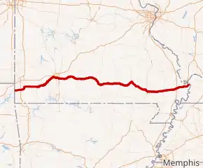
U.S. Route 60 (US 60) is a part of the United States Numbered Highway System that runs from Brenda, Arizona, east to Virginia Beach, Virginia. In the state of Missouri, US 60 is a main east–west highway that runs through the southern part of the state, from the Oklahoma border to the Illinois border.
 | ||||
|---|---|---|---|---|
US 60 highlighted in red | ||||
| Route information | ||||
| Maintained by MoDOT | ||||
| Length | 341.248 mi[1] (549.185 km) | |||
| Existed | 1926–present | |||
| Major junctions | ||||
| West end | US 60 at Oklahoma state line in Seneca | |||
| ||||
| East end |  US 60 / US 62 at Illinois state line east of Charleston US 60 / US 62 at Illinois state line east of Charleston | |||
| Location | ||||
| Counties | Newton, Barry, Lawrence, Christian, Greene, Webster, Wright, Texas, Howell, Shannon, Carter, Butler, Stoddard, New Madrid, Scott, Mississippi | |||
| Highway system | ||||
| ||||
Route description
US 60 enters Missouri from Oklahoma in Seneca south of I-44. It is a two-lane highway. It intersects I-49 in Neosho. US 60 shares a concurrency with Route 59. Route 86 has a brief concurrency with US 60 and Route 59. US 60 will turn east and leave Route 59 before passing through Granby. From Monett to Republic, US 60 has alternate passing lanes while passing through Aurora, Marionville, and Billings. In Republic, US 60 becomes a four-lane divided highway and remains a four lane to Charleston. It enters Springfield and merges onto the James River Freeway. It has a brief concurrency with US 160 and intersects Route 13. US 60 intersects US 65 before leaving Springfield and the freeway ends.
After leaving Springfield, US 60 intersects Route 125 through a stoplight which will be replaced with an interchange in the near future. It passes through Rogersville, Fordland, and Seymour. US 60 has a brief concurrency with Route 5 in Mansfield. US 60 passes through Mountain Grove. US 60 picks up a concurrency with US 63 in Cabool then US 63 departs from US 60 near Willow Springs at a freeway to freeway interchange. US 60 passes through Mountain View where the divided highway briefly ends. While passing through Mountain View, US 60 has left turn lanes and has a concurrency with Route 17. After leaving Mountain View, US 60 goes back to a divided highway. US 60 passes through Birch Tree, Winona, Van Buren and Ellsinore. Next, US 60 has a concurrency with US 67 to Poplar Bluff.
In Poplar Bluff, US 60 will separate from US 67 at a cloverleaf interchange. US 60 passes through Dexter before enter entering Sikeston where US 60 intersect I-55 and I-57 at a cloverleaf interchange and picks up a concurrency with I-57. In Charleston, US 60 will leave I-57 at exit 12. At this point, US 60 becomes a two-lane highway. US 60 will leave Missouri crossing Cairo Mississippi River Bridge along with US 62 into Illinois.[1]
History
Before the U.S. Highway system was created, US 60 was Route 16.
On May 17, 1946, William Jefferson Blythe, Jr., the biological father of Bill Clinton, died on US 60 in a car accident after he was tossed out of his vehicle and drowned in a ditch.[2]
There has been several improvements on US 60. The Missouri Department of Transportation (MoDOT) completed the process of upgrading 59 miles (95 km) of US 60 from Willow Springs to Van Buren to a four-lane highway (two lanes in each direction) on July 9, 2010, marking the completion of a four-lane highway from Republic to Charleston, a total of approximately 240 miles (390 km). Some of the at-grade intersections were replaced with interchanges.
East of US 60 and US 65 interchange in Springfield, there used to be railroad crossings that have been replaced with overpasses over the railroad tracks. That project included redesigning the US 60 and US 65 interchange. It was completed in 2012.
In 2016, US 60 through Rogersville was converted into a freeway.[3] Between Springfield and Rogersville, the junction of Route NN/J was converted into an interchange.[4]
Future
The junction of US 60 and Route 125 west of Rogersville is currently a at-grade intersection with a stoplight. There are plans to convert it into an interchange.[5]
US 60 from Poplar Bluff to Sikeston is planned to be upgraded to I-57. I-57 currently ends at I-55 in Sikeston. I-57 will then continue south following US 67 down to Arkansas.[6]
Major intersections
| County | Location | mi[1] | km | Exit | Destinations | Notes |
|---|---|---|---|---|---|---|
| Newton | Seneca | 0.000 | 0.000 | US 60 west – Wyandotte | Continuation into Oklahoma | |
| 0.438 | 0.705 |   US 60 Bus. west / Route 43 – Seneca, Tiff City US 60 Bus. west / Route 43 – Seneca, Tiff City | Roundabout | |||
| Neosho | 11.4 | 18.3 |   I-49 / US 71 – Joplin, Fort Smith I-49 / US 71 – Joplin, Fort Smith | I-49 exit 24 | ||
| 12.6 | 20.3 |   I-49 BL south / US 60 Bus. east / Route 59 (S. Neosho Boulevard) I-49 BL south / US 60 Bus. east / Route 59 (S. Neosho Boulevard) | Western end of Route 59 overlap | |||
| Neosho–Granby township line | 17.568 | 28.273 |  Route 86 west – Neosho Route 86 west – Neosho | Western end of Route 86 overlap | ||
| 17.818 | 28.675 | Route 86 east – Cassville | Eastern end of Route 86 overlap | |||
| 19.863 | 31.966 | US 60 Bus. / Route 59 – Neosho, Diamond | Eastern end of Route 59 overlap | |||
| Barry | Yonkerville | 37.285 | 60.004 |  Route 97 – Pierce City, Pulaskifield Route 97 – Pierce City, Pulaskifield | ||
| Monett | 41.712 | 67.129 |  Route 37 – Monett Route 37 – Monett | |||
| 42.551 | 68.479 |  US 60 Bus. east / Route H (Kyler Street) US 60 Bus. east / Route H (Kyler Street) | ||||
| Lawrence | Spring River Township | 47.076 | 75.761 | US 60 Bus. west – Monett | ||
| Verona | 49.395 | 79.494 | US 60 Bus. east – Verona | |||
| Aurora | 54.138 | 87.127 |   Route 265 north / Route 39 to Route 248 – Aurora Route 265 north / Route 39 to Route 248 – Aurora | Western end of Route 265 overlap | ||
| 56.356 | 90.696 | US 60 Bus. west – Aurora | ||||
| Marionville | 60.176 | 96.844 | Route 265 south – Crane | Eastern end of Route 265 overlap | ||
| 60.456 | 97.295 |  Route 14 east Route 14 east | ||||
| Christian | West Polk–East Polk township line | 65.192 | 104.916 |  Route 413 south – Crane Route 413 south – Crane | Western end of Route 413 overlap | |
| Billings | 66.153 | 106.463 | Route 14 west (Mt. Vernon Road) – McKinley | Western end of Route 14 overlap | ||
| 66.747 | 107.419 | Route 14 east (Jefferson Avenue) | Eastern end of Route 14 overlap | |||
| Greene | Republic | 73.347 | 118.041 |  Route 174 west – Chesapeake Route 174 west – Chesapeake | ||
| Springfield | 77.657 | 124.977 | — |    Route 413 north (W. Sunshine Street) / Route 360 west (James River Freeway) to I-44 – Springfield Route 413 north (W. Sunshine Street) / Route 360 west (James River Freeway) to I-44 – Springfield | Eastern end of Route 413 overlap | |
| 79.749 | 128.344 | — |    US 160 west / Route FF – Battlefield US 160 west / Route FF – Battlefield | Western end of US 160 overlap. Access to Springfield-Branson National Airport | ||
| 82.531 | 132.821 | — |  Route 13 north (Kansas Expressway) Route 13 north (Kansas Expressway) | Diverging diamond interchange; western end of Route 13 overlap | ||
| 83.696 | 134.696 | — | US 160 east / Route 13 south / Campbell Avenue – Nixa | Eastern end of US 160 and Route 13 overlaps. Access to Downtown Springfield and Bass Pro Shops | ||
| 84.905 | 136.641 | — |  National Avenue National Avenue | Access to Missouri State University, Ozarks Technical Community College, Drury University, Cox South Hospital, and Mercy Hospital | ||
| 86.248– 86.321 | 138.803– 138.920 | — |  US 65 Bus. (Glenstone Avenue) / Republic Road US 65 Bus. (Glenstone Avenue) / Republic Road | Western end of US 65 Business overlap. Access to Evangel University and Springfield Nature Center | ||
| 87.809– 87.839 | 141.315– 141.363 | — |  US 65 / US 65 Bus. ends – Branson, Sedalia US 65 / US 65 Bus. ends – Branson, Sedalia | Eastern end of US 65 Business overlap | ||
| Clay Township | 90.337 | 145.383 | — |   Route J / Route NN – Turners, Ozark Route J / Route NN – Turners, Ozark | ||
| Washington Township | 94.146 | 151.513 |  Route 125 – Linden, Strafford Route 125 – Linden, Strafford | Future interchange | ||
| Rogersville | 95.929 | 154.383 | — | Farm Road 247 | Eastbound exit and westbound entrance only | |
| 95.985– 96.770 | 154.473– 155.736 | — |  US 60 Bus. east / Route B / Farm Road 253 US 60 Bus. east / Route B / Farm Road 253 | |||
| Webster | 97.723 | 157.270 | — |  Route VV (Mill Street) Route VV (Mill Street) | ||
| 99.634 | 160.345 | US 60 Bus. west – Rogersville | ||||
| Fordland | 105.682– 106.336 | 170.079– 171.131 | — |  Route PP – Fordland Route PP – Fordland | No westbound entrance | |
| Wright | Mansfield | 126.050 | 202.858 | — |   US 60 Bus. east / Route 5 south / Route EE – Mansfield, Ava US 60 Bus. east / Route 5 south / Route EE – Mansfield, Ava | Western end of Route 5 overlap |
| 127.307 | 204.881 | — | US 60 Bus. west / Route 5 north – Mansfield, Hartville | Eastern end of Route 5 overlap | ||
| Clark Township | 132.709 | 213.574 | — |   Route K / Route Y – Macomb Route K / Route Y – Macomb | ||
| Norwood | 136.223 | 219.230 | — |   Route C / Route E – Norwood Route C / Route E – Norwood | ||
| Mountain Grove Township | 142.908 | 229.988 | — | US 60 Bus. east – Mountain Grove | ||
| Mountain Grove | 145.363 | 233.939 | — |  Route 95 – Mountain Grove Route 95 – Mountain Grove | ||
| Texas | Clinton Township | 149.284 | 240.249 | — |  US 60 Bus. west / Route MM – Mountain Grove US 60 Bus. west / Route MM – Mountain Grove | |
| 152.278 | 245.068 | — | US 60 Bus. east – Cabool | Eastbound exit and westbound entrance only | ||
| Cabool | 154.762 | 249.065 | — |  Route 181 – Cabool Route 181 – Cabool | ||
| 155.984 | 251.032 | — |  US 63 north / US 60 Bus. – Houston, Rolla US 63 north / US 60 Bus. – Houston, Rolla | Western end of US 63 overlap | ||
| Howell | Willow Springs | 164.815 | 265.244 | — | US 60 Bus. east / US 63 Bus. south – Willow Springs | |
| 167.060 | 268.857 | — |   Route 76 west / Route 137 north – Willow Springs Route 76 west / Route 137 north – Willow Springs | |||
| 169.140 | 272.204 | — | US 60 Bus. west / US 63 Bus. north – Willow Springs | |||
| Willow Springs Township | 169.895 | 273.419 | — | US 63 south – West Plains, Thayer | Eastern end of US 63 overlap | |
| Mountain View | 183.363 | 295.094 |  Route 17 south – West Plains Route 17 south – West Plains | Western end of Route 17 overlap | ||
| 184.902 | 297.571 | Route 17 north | Eastern end of Route 17 overlap | |||
| Shannon | Birch Tree | 195.302 | 314.308 |  Route 99 south / Route FF – Birch Tree Route 99 south / Route FF – Birch Tree | ||
| Winona | 203.789 | 327.967 |  Route 19 south – Alton Route 19 south – Alton | Western end of Route 19 overlap | ||
| 204.594 | 329.262 | Route 19 north – Eminence | Eastern end of Route 19 overlap | |||
| Carter | Chicopee | 224.722 | 361.655 |  Route 103 south – Big Spring Route 103 south – Big Spring | ||
| Van Buren | 225.222 | 362.460 | US 60 Bus. east | |||
| Carter Township | 226.725 | 364.879 |    US 60 Bus. west to Route D / Route W US 60 Bus. west to Route D / Route W | |||
| 231.261 | 372.179 |   Route 21 north / Route 34 – Ellington Route 21 north / Route 34 – Ellington | Western end of Route 21 overlap | |||
| Johnson Township | 241.196 | 388.167 | Route 21 south – Hunter, Grandin, Doniphan | Eastern end of Route 21 overlap | ||
| Butler | Black River Township | 260.535 | 419.290 | — |  US 67 north – St. Louis US 67 north – St. Louis | Western end of US 67 overlap |
| Poplar Bluff | 265.007– 265.738 | 426.487– 427.664 | — | .svg.png.webp) Future I-57 south / US 67 east / US 60 Bus. south / US 67 Bus. – Poplar Bluff, Corning AR Future I-57 south / US 67 east / US 60 Bus. south / US 67 Bus. – Poplar Bluff, Corning AR | Cloverleaf interchange; Eastern end of Future I-57 and US 67 overlap | |
| Poplar Bluff Township | 270.884 | 435.946 | — | US 60 Bus. – Poplar Bluff | Westbound exit and eastbound entrance only | |
| 271.506 | 436.947 | — |   Route T / Route AA – Lake Wappapello Route T / Route AA – Lake Wappapello | |||
| Stoddard | Duck Creek Township | 279.397 | 449.646 | — |  Route 51 – Fisk, Puxico Route 51 – Fisk, Puxico | |
| 285.153 | 458.909 | — |   Route TT / Route WW – Dudley Route TT / Route WW – Dudley | |||
| Dexter | 290.567 | 467.622 | — |  US 60 Bus. east / Route AD – Dexter US 60 Bus. east / Route AD – Dexter | ||
| 292.101 | 470.091 | — | One Mile Road – Dexter | |||
| Liberty Township | 293.732 | 472.716 | — |  US 60 Bus. west / Route 25 – Dexter, Bloomfield US 60 Bus. west / Route 25 – Dexter, Bloomfield | ||
| Richland Township | 301.238 | 484.796 |   Route 153 south / Route N – Circle City, Parma Route 153 south / Route N – Circle City, Parma | |||
| 306.429 | 493.150 |  Route 114 – Morehouse Route 114 – Morehouse | ||||
| New Madrid | Big Prairie Township | 311.034 | 500.561 | US 60 Bus. east / Route FF to Route 114 | ||
| Sikeston | 313.917 | 505.200 | — |  US 61 east / US 62 / US 60 Bus. – Sikeston, New Madrid US 61 east / US 62 / US 60 Bus. – Sikeston, New Madrid | ||
| Scott | 316.675 | 509.639 | 1 |  I-55 – St. Louis, Memphis I-55 – St. Louis, Memphis  I-57 begins I-57 begins | Cloverleaf interchange; Western end of I-57 overlap; signed as exits 1A (south) and 1B (north) | |
| Mississippi | Long Prairie Township | 321.591 | 517.551 | 4 | Route B – Bertrand | |
| Charleston | 327.420 | 526.931 | 10 |   I-57 BL north / Route 105 – Charleston, East Prairie I-57 BL north / Route 105 – Charleston, East Prairie | ||
| 329.752 | 530.684 | 12 |  I-57 north / I-57 BL south / US 62 west / Route 77 north – Charleston, Wyatt I-57 north / I-57 BL south / US 62 west / Route 77 north – Charleston, Wyatt | Eastern end of I-57 overlap; western end of US 62 and Route 77 overlaps | ||
| Wilson City | 334.873 | 538.926 | Route 77 south / Route Y – Wyatt, Alfalfa Center | Eastern end of Route 77 overlap | ||
| Mississippi River | 341.248 | 549.185 | Cairo Mississippi River Bridge; Missouri–Illinois state line | |||
| US 60 east / US 62 east – Cairo | Continuation into Illinois | |||||
1.000 mi = 1.609 km; 1.000 km = 0.621 mi
| ||||||
See also
 U.S. Roads portal
References
- Missouri Department of Transportation (November 27, 2020). MoDOT HPMAPS (Map). Missouri Department of Transportation. Retrieved November 27, 2020.
- Weingarten, Gene (June 20, 1993). "The First Father: William Jefferson Blythe and the Back Roads of Fate". The Washington Post. ISSN 0190-8286. Retrieved December 11, 2020.
- "Project Freeway: U.S. 60 Rogersville - COMPLETED | Missouri Department of Transportation". www.modot.org. Retrieved September 28, 2021.
- "U.S. Route 60 at Greene County Routes NN/J Interchange Project - Construction Projects - News | Transportation Management Center OzarksTraffic". www.ozarkstraffic.com. Retrieved September 28, 2021.
- "Route 60 at Route 125 Interchange". Missouri Department of Transportation. Retrieved March 21, 2021.
- "U.S. 67 (Future I-57) in Butler County". Missouri Department of Transportation. Retrieved August 29, 2021.