Wisconsin Highway 146
State Trunk Highway 146 (often called Highway 146, STH-146 or WIS 146) is a state highway in the U.S. state of Wisconsin. It runs north–south in central Wisconsin from Fall River to Cambria.
 | ||||
|---|---|---|---|---|
| Route information | ||||
| Maintained by WisDOT | ||||
| Length | 13.22 mi[1] (21.28 km) | |||
| Major junctions | ||||
| South end |  WIS 16 near Fall River WIS 16 near Fall River | |||
| North end |  WIS 33 near Cambria WIS 33 near Cambria | |||
| Location | ||||
| Counties | Columbia | |||
| Highway system | ||||
| ||||


Route description
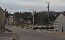
Looking north on Highway 146 in Cambria
Starting at WIS 16 northwest of Fall River, WIS 146 begins its journey northward. It then meanders northward to Cambria. In Cambria, WIS 146 turns north via Williams Street, west via Florence Street, and then north again via Madison Street. After leaving Cambria, it then meets WIS 33. At this point, the route ends there and continues as County Trunk Highways M (CTH-M).[2]
Major intersections
The entire highway is in Columbia County.
| Location | mi[1] | km | Destinations | Notes | |
|---|---|---|---|---|---|
| Town of Fountain Prairie | 0.00 | 0.00 | WIS 16 – Columbus, Portage | ||
| Town of Randolph | 13.22 | 21.28 | WIS 33 – Fox Lake, Portage | ||
| 1.000 mi = 1.609 km; 1.000 km = 0.621 mi | |||||
See also
 U.S. Roads portal
References
- Bessert, Chris. "Highways 140–149". Wisconsin Highways. Retrieved March 20, 2007.
- Google (March 13, 2021). "Overview Map of WIS 146" (Map). Google Maps. Google. Retrieved March 13, 2021.
External links
 Media related to Wisconsin Highway 146 at Wikimedia Commons
This article is issued from Wikipedia. The text is licensed under Creative Commons - Attribution - Sharealike. Additional terms may apply for the media files.