Abra (province)
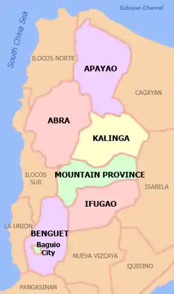
Abra, officially the Province of Abra (Ilocano: Probinsia ti Abra; Tagalog: Lalawigan ng Abra), is a 3rd class province in the Cordillera Administrative Region of the Philippines. Its capital is the municipality of Bangued. It is bordered by Ilocos Norte on the northwest, Apayao on the northeast, Kalinga on the mid-east, Mountain Province on the southeast, and Ilocos Sur on the southwest.
Abra | |
|---|---|
| Province of Abra | |
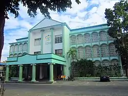 Abra Provincial Capitol | |
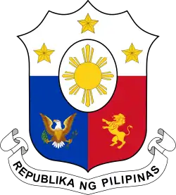
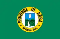 Flag  Seal | |
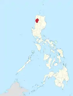 Location in the Philippines | |
| Coordinates: 17°35′N 120°45′E | |
| Region | Cordillera Administrative Region |
| Founded | 10 March 1917 |
| Capital | Bangued |
| Government | |
| • Type | Sangguniang Panlalawigan |
| • Governor | Maria Jocelyn Acosta Valera-Bernos (NUP/HNP) |
| • Vice Governor | Ronald Stimson Balao-as (NUP) |
| • Legislature | Abra Provincial Board |
| Area | |
| • Total | 4,165.25 km2 (1,608.21 sq mi) |
| Area rank | 29th out of 81 |
| Highest elevation (Mount Bangbanglang) | 2,467 m (8,094 ft) |
| Population | |
| • Total | 250,985 |
| • Rank | 68th out of 81 |
| • Density | 60/km2 (160/sq mi) |
| • Density rank | 80th out of 81 |
| Divisions | |
| • Independent cities | 0 |
| • Component cities | 0 |
| • Municipalities | |
| • Barangays | 303 |
| • Districts | Legislative districts of Abra |
| Time zone | UTC+8 (PHT) |
| ZIP code | 2800–2826 |
| IDD : area code | +63 (0)74 |
| ISO 3166 code | PH-ABR |
| Spoken languages | |
| Website | www |
Etymology
Abra is from the Spanish word abre meaning gorge, pass, breach or opening. It was first used by the Spaniards to denote the region above the Banaoang Gap where the Abra River exits into the West Philippine Sea, thus the Rio Grande de Abra.[3]
Official Seal of Abra
Meaning of the Official Seal:[3]
- Twin peaks on both sides of a river
- Paddled fields: Signifies that the main occupation of and mean of livelihood of the people of Abra is farming.
- Prancing stallion: Means that Abra was once famous for its horses - noted for their strength, speed and endurance.
History
Pre-colonial period
The first inhabitants of Abra were the ancestors of the Bontocs and the Ifugaos. These inhabitants eventually left to settle in the old Mountain Province. Other early inhabitants were the Tingguians, or Itnegs, as they are also known.
Spanish era
In 1585, the Tingguians were mentioned for the first time in a letter of Father Domingo de Salazar to the King of Spain.
In 1598, Bangued is occupied by Spanish-Iloko forces. They established a Spanish garrison to protect the Spanish missionaries from the head hunters, to Christianize the Tingguians, and to locate gold mines.
At first no missionary center was established in Bangued. Bangued then was under the care of the missionaries stationed in Vigan or Bantay. Due to conversions made by Fr. Esteban Marin and Fr. Agustin Minon, a mission was founded in Bangued as early as in 1598 to act as a center for the other parts of Abra. It was suddenly created into a ministry on April 5, 1612 and Fr. Pedro Columbo became its first minister. It would seem that this actuation of the Augustinians was precipitated by the Dominican take-over of the ministry of Narvacan. The Dominicans wanted to convert Narvacan as a mission center to evangelize the other parts of Abra. To check this Dominican move, the Augustinians elevated Bangued as a ministry.
The great apostle of Abra, the Augustinian Fr. Juan Pareja, OSA, former parish priest of Bantay, led the others in the conversion of the province. He went to Abra in 1626 and after many years of hard work and sufferings, he is reported to have converted more than 3,000 including the chieftain Miguel Dumaual. Fr. Pareja founded the mission of San Diego and later the ministry of Bangued. He established the following towns as visitas of Bangued: Tayum, Sabangan and Bukao (now Dolores). Under the inspiration of Fr. Juan Pareja these towns sustained an almost daily battle against the Tinguianes of the rancherias of Palang, Talamuy, Bataan, Kabulao, Kalauag, and Langiden.
The Dominican missionary, Fr. Jose Polanco also helped a great deal in the conversion of the people of Abra and in the founding of towns. A man of austere mortification, he died in Abra in 1679; it is said that he was considered a saint by the people.
After some time the conversion of Abra lagged a little until the return of the Augustinian Fr. Bernardino Lago during the early 19th century. In 1823 Fr. Lago began work in Pidigan. After 25 years, the Christians there numbered about a thousand "baptized, living in community, with schools, church and municipal house, tilling the earth to support themselves and their children." Fr. Lago also founded the town of La Paz. Fr. Galende enumerates the foundation of the other towns of Abra:
- Tayum, 1803
- San Gregorio, 1829
- Pidigan, 1823
- La Paz, 1832
- Bucay, 1847
- San Jose, 1848
- Villavieja, 1862
- San Quintin, 1868
- Dolores, 1882
- Pilar, 1882
- San Juan, 1884
- Alfonso XII, 1884
Originally the area was called El Abra de Vigan ("The Opening of Vigan"). During the British Occupation of the Philippines, Gabriela Silang and her army fled to Abra from Ilocos and continued the revolt begun by her slain husband, Diego Silang. She was captured and hanged by the Spanish in 1763.
In 1818, the Ilocos region, including Abra, was divided into Ilocos Norte and Ilocos Sur. On October 9, 1846, Abra became an independent province with the capital and the residence of the provincial governor at Bucay. In 1863, the capital was transferred to Bangued, the province's oldest town. It remained so until the arrival of the Americans in 1899.
American period
In 1908, the Philippine Commission again annexed Abra to Ilocos Sur in an attempt to resolve Abra's financial difficulties. On March 9, 1917, the Philippine Assembly re-established Abra as a province under Act 2683.[4]
World War II
In 1942, the Japanese forces occupied the Philippines and entered Abra.
Abra was liberated by the Philippine Commonwealth forces and local Cordilleran guerrillas during the Battle of Abra in 1945, at the end of the Second World War.
Modern history
The revolutionary Marxist priest, Conrado Balweg, who fought for the rights of the Cordillera tribes, began his crusade in Abra. After successfully negotiating a peace accord with Balweg's group in 1987, the Philippine government created the Cordillera Administrative Region, which includes Abra.[5]
Geography
Abra is situated in the mid-western section of the Cordillera Administrative Region in Luzon. It is bordered by the provinces of Ilocos Norte on the northwest, Apayao on the northeast, Kalinga on the mid-east, Mountain Province on the southeast, and Ilocos Sur on the southwest. Abra has a total land area of 4,165.25 square kilometres or 1,608.21 square miles[6].
The province is hemmed in by the towering mountain ranges of the Ilocos in the west and the Cordillera Central in the east. The Abra River runs from the south in Benguet to the west and central areas, bisecting the whole Abra Valley. It is joined by the Tineg River originating from the eastern uplands at a point near the municipality of Dolores.
Administrative divisions
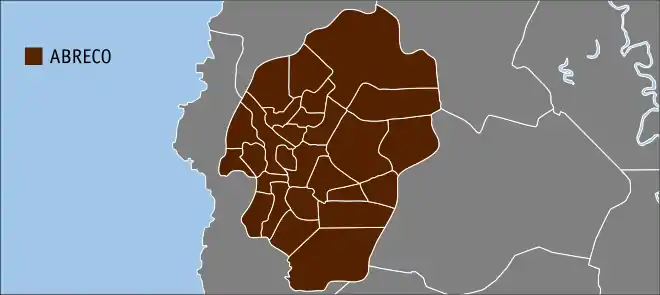
Abra is composed of 27 municipalities, all encompassed by Abra's lone congressional district.[6]
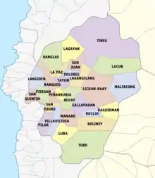
| Municipality [lower-roman 1][lower-roman 2] | Population | ±% p.a. | Area[6] | Density (2015) | Barangay | |||||||
|---|---|---|---|---|---|---|---|---|---|---|---|---|
| (2015) [7] | (2010) [8] | km2 | sq mi | /km2 | /sq mi | |||||||
| Bangued | † | 20.0% | 48,163 | 43,936 | +1.76% | 105.70 | 40.81 | 460 | 1,200 | 31 | ||
| Boliney | 1.5% | 3,573 | 4,063 | −2.42% | 216.92 | 83.75 | 16 | 41 | 8 | |||
| Bucay | 7.1% | 17,115 | 17,126 | −0.01% | 107.17 | 41.38 | 160 | 410 | 21 | |||
| Bucloc | 1.0% | 2,501 | 2,176 | +2.69% | 63.77 | 24.62 | 39 | 100 | 4 | |||
| Daguioman | 0.9% | 2,088 | 1,715 | +3.82% | 114.37 | 44.16 | 18 | 47 | 4 | |||
| Danglas | 1.7% | 4,192 | 4,734 | −2.29% | 156.02 | 60.24 | 27 | 70 | 7 | |||
| Dolores | 4.7% | 11,315 | 11,499 | −0.31% | 47.45 | 18.32 | 240 | 620 | 15 | |||
| La Paz | 6.4% | 15,437 | 14,882 | +0.70% | 51.41 | 19.85 | 300 | 780 | 12 | |||
| Lacub | 1.4% | 3,403 | 2,977 | +2.58% | 295.30 | 114.02 | 12 | 31 | 6 | |||
| Lagangilang | 5.9% | 14,255 | 13,824 | +0.59% | 101.44 | 39.17 | 140 | 360 | 17 | |||
| Lagayan | 1.9% | 4,499 | 4,477 | +0.09% | 215.97 | 83.39 | 21 | 54 | 5 | |||
| Langiden | 1.3% | 3,198 | 3,170 | +0.17% | 116.29 | 44.90 | 28 | 73 | 6 | |||
| Licuan-Baay (Licuan) | 1.9% | 4,689 | 4,864 | −0.70% | 256.42 | 99.00 | 18 | 47 | 11 | |||
| Luba | 2.6% | 6,339 | 6,391 | −0.16% | 148.27 | 57.25 | 43 | 110 | 8 | |||
| Malibcong | 1.4% | 3,428 | 3,807 | −1.98% | 283.17 | 109.33 | 12 | 31 | 12 | |||
| Manabo | 4.5% | 10,761 | 10,756 | +0.01% | 110.95 | 42.84 | 97 | 250 | 11 | |||
| Peñarrubia | 2.8% | 6,640 | 6,544 | +0.28% | 38.29 | 14.78 | 170 | 440 | 9 | |||
| Pidigan | 5.1% | 12,185 | 11,528 | +1.06% | 49.15 | 18.98 | 250 | 650 | 15 | |||
| Pilar | 4.2% | 10,223 | 9,908 | +0.60% | 66.10 | 25.52 | 150 | 390 | 19 | |||
| Sallapadan | 2.7% | 6,622 | 5,985 | +1.94% | 128.62 | 49.66 | 51 | 130 | 9 | |||
| San Isidro | 1.9% | 4,574 | 4,888 | −1.26% | 48.07 | 18.56 | 95 | 250 | 9 | |||
| San Juan | 4.1% | 9,867 | 10,546 | −1.26% | 64.08 | 24.74 | 150 | 390 | 19 | |||
| San Quintin | 2.3% | 5,438 | 5,233 | +0.73% | 66.59 | 25.71 | 82 | 210 | 6 | |||
| Tayum | 6.0% | 14,467 | 13,940 | +0.71% | 61.14 | 23.61 | 240 | 620 | 11 | |||
| Tineg | 2.1% | 5,097 | 4,668 | +1.69% | 744.80 | 287.57 | 6.8 | 18 | 10 | |||
| Tubo | 2.4% | 5,699 | 5,719 | −0.07% | 409.87 | 158.25 | 14 | 36 | 10 | |||
| Villaviciosa | 2.2% | 5,392 | 5,377 | +0.05% | 102.93 | 39.74 | 52 | 130 | 8 | |||
| Total | 241,160 | 234,733 | +0.52% | 4,165.25 | 1,608.21 | 56 | 150 | 303 | ||||
| † Provincial capital | Municipality | |||||||||||
| ||||||||||||

Demographics
The population of Abra in the 2020 census was 250,985 people, [2] with a density of 60 inhabitants per square kilometre or 160 inhabitants per square mile.
Abra's inhabitants are mostly descendants of Ilocano settlers and members of the Tingguian tribe. Based on the 2000 census survey, Ilocanos comprised 71.94% (150,457) of the total provincial population of 209,146. Tingguians came in second at 18.7% (39,115), while other ethnic groups in the province were the Ibanag at 4.46% (9,334), Itneg at 3.17% (6,624), and Tagalog at 0.42% (869).[9]
The predominant languages are Ilocano[10] and Itneg.[11]
| Year | Pop. | ±% p.a. |
|---|---|---|
| 1903 | 51,860 | — |
| 1918 | 72,731 | +2.28% |
| 1939 | 87,780 | +0.90% |
| 1948 | 86,600 | −0.15% |
| 1960 | 115,193 | +2.41% |
| 1970 | 145,508 | +2.36% |
| 1975 | 147,010 | +0.21% |
| 1980 | 160,198 | +1.73% |
| 1990 | 184,743 | +1.44% |
| 1995 | 195,964 | +1.11% |
| 2000 | 209,491 | +1.44% |
| 2007 | 230,953 | +1.35% |
| 2010 | 234,733 | +0.59% |
| 2015 | 241,160 | +0.52% |
| 2020 | 250,985 | +0.79% |
| Source: PSA [7] [8] [12] | ||
Economy
As of 1990, there were 743 cottage industries in Abra, of which 208 are registered with the Department of Trade and Industry. 59% are engaged in bamboo and rattan craft making, both leading industries in the area.
Abra's economy is agriculture-based. Its major crops are rice, corn, and vegetables, root crops; commercial products include coffee, tobacco, and coconut. Extensive grassland and pasture areas are used for livestock production.
Infrastructure
Power distribution
Government
List of former military and elected governors:[20]
- Don Ramon Tajonera y Marzal (Military Governor): 1846-?
- Don Esteban de Penarrubia (Military Governor): 1868-?
- Col. William Bowen (Military Governor): 1901
- Juan G. Villamor (Governor): 1902–1904
- Joaquin J. Ortega (Governor): 1904–1914
- Rosalio G. Eduarte (Governor): 1914–1916
- Julio V. Borbon (Governor): 1916–1922
- Virgilio V. Valera (Governor): 1922–1925
- Eustaquio P. Purugganan (Governor): 1925–1930
- Virgilio V. Valera (Governor): 1930–1936
- Bienvenido N. Valera (Governor): 1936–1939
- Eustaquio P. Purugganan (Governor): 1939–1941
- Bernardo V. Bayquen (Governor): 1941–1944
- Zacarias A. Crispin (Governor): 1944–1946
- Juan C. Brillantes (Governor): 1946–1947
- Luis F. Bersamin (Governor): 1947–1951
- Lucas P. Paredes (Governor): 1951–1953
- Vene B. Pe Benito was acting governor in 1953
- Ernesto P. Parel (Governor): 1953–1954
- Jose L. Valera 1954–1963
- Carmelo Z. Barbero (Governor): 1963–1965
- Petronilo V. Seares (Governor): 1965–1971
- Gabino V. Balbin (Governor): 1971–1977
- Arturo V. Barbero (Governor): 1977–1984
- Andres B. Bernos (Governor): 1984–1986
- Vicente P. Valera (Governor): 1986–1987
- Buenaventura V. Buenafe was acting governor in 1987
- Vicente Y. Valera (Governor): 1988–1998
- Constante B. Culangen was acting governor in 1998
- Maria Zita Claustro-Valera (Governor): 1998–2001
- Vicente Y. Valera (Governor): 2001–2007
- Eustaquio P. Bersamin (Governor): 2007–2016
- Maria Jocelyn Valera Bernos (Governor): 2016-present
References
- "List of Provinces". PSGC Interactive. Makati, Philippines: National Statistical Coordination Board. Archived from the original on April 19, 2016. Retrieved May 14, 2014.
- Census of Population (2020). "Cordillera Administrative Region (CAR)". Total Population by Province, City, Municipality and Barangay. PSA. Retrieved July 8, 2021.
- "The Ilocos Review Volume 19 - 1987". The Ilocos Review. Arnoldus Press, Inc. ISSN 0019-2538.
- "Act No. 2683; An Act to Authorize the Segregation of the Subprovince of Abra from the Province of Ilocos Sur and the Reestablishment of the Former Province of Abra, and for Other Purposes". Supreme Court E-Library. March 9, 1917. Retrieved March 18, 2016.
- "Executive Order No. 220; Creating a Cordillera Administrative Region, Appropriating Funds Therefor and for Other Purposes". The LawPhil Project. Manila, Philippines. July 15, 1987. Retrieved July 29, 2016.
Sec. 2. Territorial Coverage. For purposes of the CAR, the region shall consist of the provinces of Abra, Benguet, Ifugao, Kalinga-Apayao and Mt. Province and the chartered city of Baguio. Until otherwise provided by the Cordillera Executive Board (CEB), the seat of the CAR shall be Baguio City.
- "Province: Abra (province)". PSGC Interactive. Quezon City, Philippines: Philippine Statistics Authority. Retrieved January 8, 2016.
- Census of Population (2015). "Cordillera Administrative Region (CAR)". Total Population by Province, City, Municipality and Barangay. PSA. Retrieved June 20, 2016.
- Census of Population and Housing (2010). "Cordillera Administrative Region (CAR)". Total Population by Province, City, Municipality and Barangay. NSO. Retrieved June 29, 2016.
- "Abra: Housing Unit Occupancy Rate Nears 100%; Table 5. Household Population by Ethnicity and Sex: Abra, 2000". Philippine Statistics Authority. April 3, 2002. Archived from the original on March 5, 2012. Retrieved December 4, 2015.
- Dalby, Andrew (February 18, 2004). Dictionary of Languages: The Definitive Reference to More Than 400 Languages. Columbia University Press. p. 264. ISBN 978-0-231-11569-8.
- Tryon, Darrell T. (1994). Comparative Austronesian Dictionary: An Introduction to Austronesian Studies. Ratzlow-Druck. p. 171. ISBN 3-11-012729-6.
- Census of Population and Housing (2010). Population and Annual Growth Rates for The Philippines and Its Regions, Provinces, and Highly Urbanized Cities (PDF). NSO. Retrieved June 29, 2016.
- "Poverty incidence (PI):". Philippine Statistics Authority. Retrieved December 28, 2020.
- https://psa.gov.ph/sites/default/files/NSCB_LocalPovertyPhilippines_0.pdf; publication date: 29 November 2005; publisher: Philippine Statistics Authority.
- https://psa.gov.ph/sites/default/files/2009%20Poverty%20Statistics.pdf; publication date: 8 February 2011; publisher: Philippine Statistics Authority.
- https://psa.gov.ph/sites/default/files/Table%202.%20%20Annual%20Per%20Capita%20Poverty%20Threshold%2C%20Poverty%20Incidence%20and%20Magnitude%20of%20Poor%20Population%2C%20by%20Region%20and%20Province%20%20-%202006%2C%202009%2C%202012%20and%202015.xlsx; publication date: 27 August 2016; publisher: Philippine Statistics Authority.
- https://psa.gov.ph/sites/default/files/Table%202.%20%20Annual%20Per%20Capita%20Poverty%20Threshold%2C%20Poverty%20Incidence%20and%20Magnitude%20of%20Poor%20Population%2C%20by%20Region%20and%20Province%20%20-%202006%2C%202009%2C%202012%20and%202015.xlsx; publication date: 27 August 2016; publisher: Philippine Statistics Authority.
- https://psa.gov.ph/sites/default/files/Table%202.%20%20Annual%20Per%20Capita%20Poverty%20Threshold%2C%20Poverty%20Incidence%20and%20Magnitude%20of%20Poor%20Population%2C%20by%20Region%20and%20Province%20%20-%202006%2C%202009%2C%202012%20and%202015.xlsx; publication date: 27 August 2016; publisher: Philippine Statistics Authority.
- https://psa.gov.ph/sites/default/files/Table%202.%20%20Updated%20Annual%20Per%20Capita%20Poverty%20Threshold%2C%20Poverty%20Incidence%20and%20Magnitude%20of%20Poor%20Population%20with%20Measures%20of%20Precision%2C%20by%20Region%20and%20Province_2015%20and%202018.xlsx; publication date: 4 June 2020; publisher: Philippine Statistics Authority.
- Gaioni, SVD, Fr. Dominic T. "Historical Highlights of the Province of Abra From 1585 to 1920". Cite journal requires
|journal=(help)
External links
 |
Wikivoyage has a travel guide for Abra. |
 Media related to Abra (province) at Wikimedia Commons
 Geographic data related to Abra (province) at OpenStreetMap
- History articles and links on Bucay and Abra
Places adjacent to Abra (province) | |
|---|---|


| Province of Abra | |
|---|---|
Bangued (capital) | |
| Municipalities | |
| Barangays | |

Authority control  |
|---|