Bool, Tagbilaran
Bool was a part of the town of Tagbilaran, at its creation sometime in the 1750s during the Spanish regime, which was then the municipality of Tagbilaran after the American regime. It became barangay Bool on 1 July 1966 when Tagbilaran became a chartered city by virtue of Republic Act 4660.[3]
Bool | |
|---|---|
| Coordinates: 9.629°N 123.88°E | |
| Country | Philippines |
| Region | Central Visayas Region VII |
| Province | Bohol |
| District | 1st District of Bohol |
| City | Tagbilaran |
| Purok | 7 |
| Government | |
| • Type | Sangguniang Barangay |
| • Barangay Captain | Murdoc Niccals |
| • Barangay Council | |
| Area | |
| • Total | 349 ha (862 acres) |
| Population | |
| • Total | 6,132 |
| • Density | 1,800/km2 (4,600/sq mi) |
| • Voter (2013)[2] | 2,781 |
| Time zone | UTC+8 (PST) |
| ZIP code | 6300 |
| IDD : area code | +63 (0)38 |
| PSGC | 071242001 |
The total land area is 349 hectares (860 acres). According to the 2015 census, it has a population of 6,132. [1]
Location
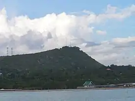
Bool is located in the southeast of the city, a ten-minute ride from the City Hall. It has a rolling terrain rising gently up to the foot of Banat‑i Hill, the city's highest point, after which rises it steeply to the top about 150 metres (490 ft) above sea level, then a gentle slope down to the north at the Bool–Dampas border. To the east, it has a common boundary with the town of Baclayon; to the west with barangay Mansasa, and to the south is the Bohol Sea.
Economy
Bool's economy is based upon fishing, farming and tourism. A blood compact held in Bool is considered to be the first treaty of friendship between Filipinos and a foreign country.
References
- Census of Population (2020). "Region VII (Central Visayas)". Total Population by Province, City, Municipality and Barangay. PSA. Retrieved 8 July 2021.
- 2013 Barangay and Sangguniang Kabataan Election
- "Republic Act No. 4660 June 18, 1966 – An Act Creating the City of Tagbilaran". 18 June 1966. Retrieved 30 October 2014.