Campos del Río
Campos del Río is a municipality in the autonomous region of Murcia in southeastern Spain.It covers an area of 47.3 km2[2] and shares borders with Ojós at its north, Villanueva del Río Segura and Alguazas at its north-east, Las Torres de Cotillas at its east, Murcia at its south-east, Mula and Albudeite at its south and west and Ricote at its north-west.[3]
Campos del Río | |
|---|---|
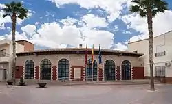 | |
.svg.png.webp) Coat of arms | |
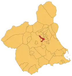 Location in Murcia | |
  Campos del Río Location in Murcia  Campos del Río Location in Spain | |
| Coordinates: | |
| Country |  Spain Spain |
| Autonomous community |  Murcia Murcia |
| Province | Murcia |
| Comarca | Río Mulal |
| Government | |
| • Mayor | Miguel Buendía |
| Area | |
| • Total | 47.29 km2 (18.26 sq mi) |
| Elevation | 172 m (564 ft) |
| Population (2018)[1] | |
| • Total | 2,045 |
| • Density | 43/km2 (110/sq mi) |
| Time zone | UTC+1 (CET) |
| • Summer (DST) | UTC+2 (CEST) |
| Website | Official website |
Demography
6.26% of the inhabitants are foreigners – 3.79% are Africans, 1.38% are Americans and 0.936% are Asians.[4]The table below shows the population trend by decades of the 20th and 21st centuries.[5]
| 1900 | 1910 | 1920 | 1930 | 1940 | 1950 | 1960 | 1970 | 1981 | 1991 | 2001 | 2011 | |
|---|---|---|---|---|---|---|---|---|---|---|---|---|
| Population | 1,517 | 1,690 | 1,743 | 1,942 | 1,971 | 2,274 | 2,222 | 2,021 | 2,046 | 1,949 | 2,046 | 2,201 |
Economy
27.7% of the territory was used for crop purposes in 2019,[6]the most widely grown products are the almonds,[7] and 44.46% of the agreements were signed by workers of the agriculture sector.[8]
References
- Municipal Register of Spain 2018. National Statistics Institute.
- "Portal Estadístico de la Región de Murcia - CREM".
- "Figura 1: Mapa de municipios de la Región de Murcia".
- "CREM - Datos Municipales Campos del Río - 5. Evolución de la población según nacionalidad". Portal Economómico de la Región de Murcia - CREM (in Spanish).
- "CREM - Datos Municipales Campos del Río - 1. Censos de Población. Evolución de la población según sexo". Portal Economómico de la Región de Murcia - CREM (in Spanish).
- "CREM - Datos Municipales Campos del Río". Portal Economómico de la Región de Murcia - CREM (in Spanish).
- {{Cite web|title=CREM - Datos Municipales Campos del Río - 3. Evolución de la superficie dedicada a cada grupo de cultivo.|url=https://econet.carm.es/web/crem/inicio/-/crem/sicrem/PU_CamposDelRioCifras/P8004/sec4.html%7Cwebsite=Portal Económico de la Región de Murcia - CREM
- (in Spanish) https://www.sefcarm.es/web/Blob?ARCHIVO=Campos_del_Rio.pdf&TABLA=ARCHIVOS&CAMPOCLAVE=IDARCHIVO&VALORCLAVE=65467&CAMPOIMAGEN=ARCHIVO&IDTIPO=60&RASTRO=c$m5082,5147,6887,26500. Missing or empty
|title=(help)
Authority control  |
|---|
This article is issued from Wikipedia. The text is licensed under Creative Commons - Attribution - Sharealike. Additional terms may apply for the media files.