Carnoux-en-Provence
Carnoux-en-Provence (French pronunciation: [kaʁnu ɑ̃ pʁɔvɑ̃s]; Occitan: Carnós de Provença), commonly referred to as Carnoux, is a commune located 16.4 km (10.2 mi) from the northeast of Marseille in the Bouches-du-Rhône department in the Provence-Alpes-Côte d'Azur region in Southern France. It was created in 1966 from the commune of Roquefort-la-Bédoule. In 2018, it had a population of 6,564.
Carnoux-en-Provence
| |
|---|---|
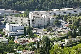 A view of Carnoux-en-Provence | |
.svg.png.webp) Coat of arms | |
Location of Carnoux-en-Provence 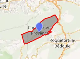
| |
  Carnoux-en-Provence  Carnoux-en-Provence | |
| Coordinates: 43°15′23″N 5°33′52″E | |
| Country | France |
| Region | Provence-Alpes-Côte d'Azur |
| Department | Bouches-du-Rhône |
| Arrondissement | Marseille |
| Canton | La Ciotat |
| Intercommunality | Aix-Marseille-Provence |
| Government | |
| • Mayor (2020–2026) | Jean-Pierre Giorgi |
| Area 1 | 3.45 km2 (1.33 sq mi) |
| Population | 6,564 |
| • Density | 1,900/km2 (4,900/sq mi) |
| Time zone | UTC+01:00 (CET) |
| • Summer (DST) | UTC+02:00 (CEST) |
| INSEE/Postal code | 13119 /13470 |
| Dialling codes | 0491 |
| Elevation | 180–380 m (590–1,250 ft) |
| 1 French Land Register data, which excludes lakes, ponds, glaciers > 1 km2 (0.386 sq mi or 247 acres) and river estuaries. | |
Camp de Carpiagne, the garrison for the 1st-11th Cuirassier Regiment armoured (tank) regiment of the French Army is found here.
History
In 1957, French citizens repatriated from Morocco established the town of Carnoux on the land of Roquefort-la-Bédoule, where those repatriated from Algeria were also welcomed from 1962.[2]
In 1966, the commune of Carnoux-en-Provence was officially created, becoming the 119th commune in Bouches-du-Rhône.[3] The city's urban and municipal policies were developed by French architect Jean Rozan (1887–1977).
Population
Population development since 1968:
| Year | Pop. | ±% |
|---|---|---|
| 1968 | 2,207 | — |
| 1975 | 3,120 | +41.4% |
| 1982 | 5,149 | +65.0% |
| 1990 | 6,363 | +23.6% |
| 1999 | 7,042 | +10.7% |
| 2008 | 6,999 | −0.6% |
| 2016 | 6,546 | −6.5% |
Geography
Situation
Carnoux-en-Provence is situated to the east of Marseille, with Aubagne to the north and Cassis to the south, with hills to the east extending to the Massif de Saint-Cyr.
Climat
Carnoux-en-Provence benefits from a Mediterranean weather.
Adjacent towns
- Aubagne to the north and west;
- Cassis to the south;
- Roquefort-la-Bédoule to the southeast and east.
List of mayors
| Term start | Term end | Name | Affiliation |
|---|---|---|---|
| January 1967 | March 1971 | Pierre Maret | |
| March 1971 | December 1977 (resignation) | Adolphe Faure | |
| January 1978 | March 1983 | Marc Laprie | |
| March 1983 | March 2001 | Jean Chaland[5] | DVD |
| March 2001 | In office | Jean-Pierre Giorgi | DVD |
References
- "Populations légales 2018". The National Institute of Statistics and Economic Studies. 28 December 2020.
- "Histoire de Carnoux". Archived from the original on 2011-11-23. Retrieved 2019-12-15.
- Site sur la Population et les Limites Administratives de la France
- Discours de Jean Chaland à l'occasion des 30 ans de Carnoux-en-Provence
- "Jean Chaland nous a quittés". La Provence. 2014-02-14.
 |
Wikimedia Commons has media related to Carnoux-en-Provence. |
Authority control  | |
|---|---|
| General | |
| National libraries | |