Chatham County, Georgia
Chatham County (/ˈtʃætəm/ CHAT-əm) is located in the U.S. state of Georgia, on the state's Atlantic coast. The county seat and largest city is Savannah. One of the original counties of Georgia, Chatham County was created February 5, 1777, and is named after William Pitt, 1st Earl of Chatham.[1]
Chatham County | |
|---|---|
 Chatham County Administrative and Legislative Center in Savannah | |
 Seal | |
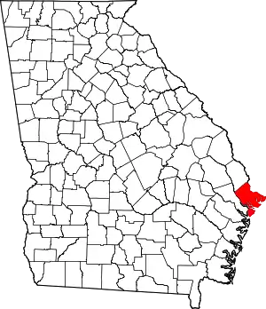 Location within the U.S. state of Georgia | |
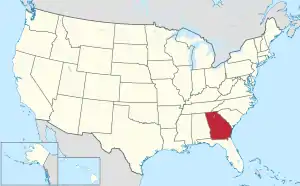 Georgia's location within the U.S. | |
| Coordinates: 31°58′N 81°05′W | |
| Country |  United States United States |
| State | .svg.png.webp) Georgia Georgia |
| Founded | February 5, 1777 |
| Named for | William Pitt, 1st Earl of Chatham |
| Seat | Savannah |
| Largest city | Savannah |
| Area | |
| • Total | 632 sq mi (1,640 km2) |
| • Land | 426 sq mi (1,100 km2) |
| • Water | 206 sq mi (530 km2) 32.6%% |
| Population (2020) | |
| • Total | 295,291 |
| • Density | 622/sq mi (240/km2) |
| Time zone | UTC−5 (Eastern) |
| • Summer (DST) | UTC−4 (EDT) |
| Congressional district | 1st |
| Website | www |
The U.S. Census Bureau's official 2020 population for Chatham County was 295,291 residents.[2] Chatham is the sixth most populous county in Georgia, and the most populous Georgia county outside the Atlanta metropolitan area. The official 2010 Census counted 265,128 residents in Chatham County.[3] Chatham is the core county of the Savannah metropolitan area.
Geography
According to the U.S. Census Bureau, the county has a total area of 632 sq mi (1,640 km2), of which 206 sq mi (530 km2) (32.6%) is covered by water.[4]
Chatham County is the northernmost of Georgia's coastal counties on the Atlantic Ocean. It is bounded on the northeast by the Savannah River, and in the southwest bounded by the Ogeechee River.
The bulk of Chatham County, an area with a northern border in a line from Bloomingdale to Tybee Island, is located in the Ogeechee River Coastal subbasin of the Ogeechee River basin. The portion of the county north of that line is located in the lower Savannah River subbasin of the Savannah River basin, while the very southern fringes of the Chatham County are located in the lower Ogeechee River subbasin of the Ogeechee River basin.[5]
Major highways
.svg.png.webp) Interstate 16
Interstate 16.svg.png.webp) Interstate 95
Interstate 95.svg.png.webp) Interstate 516
Interstate 516 U.S. Route 17
 U.S. Route 80
 State Route 17
 State Route 21
 State Route 21 Spur
 State Route 25
 State Route 26
- State Route 26 Connector
 State Route 30
 State Route 204
 State Route 204 Spur
 State Route 307
 State Route 404 (unsigned designation for I-16)
 State Route 404 Spur
 State Route 405 (unsigned designation for I-95)
 State Route 421 (unsigned designation for I-516)
 Savannah River Parkway
Adjacent counties
- Jasper County, South Carolina – northeast
- Bryan County – west/southwest
- Liberty County - southeast
- Effingham County – northwest
National protected areas
Demographics
| Historical population | |||
|---|---|---|---|
| Census | Pop. | %± | |
| 1790 | 10,769 | — | |
| 1800 | 12,946 | 20.2% | |
| 1810 | 13,540 | 4.6% | |
| 1820 | 14,737 | 8.8% | |
| 1830 | 14,127 | −4.1% | |
| 1840 | 18,801 | 33.1% | |
| 1850 | 23,901 | 27.1% | |
| 1860 | 31,043 | 29.9% | |
| 1870 | 41,279 | 33.0% | |
| 1880 | 45,023 | 9.1% | |
| 1890 | 57,740 | 28.2% | |
| 1900 | 71,239 | 23.4% | |
| 1910 | 79,690 | 11.9% | |
| 1920 | 100,032 | 25.5% | |
| 1930 | 105,431 | 5.4% | |
| 1940 | 117,970 | 11.9% | |
| 1950 | 151,481 | 28.4% | |
| 1960 | 188,299 | 24.3% | |
| 1970 | 187,767 | −0.3% | |
| 1980 | 202,226 | 7.7% | |
| 1990 | 216,935 | 7.3% | |
| 2000 | 232,048 | 7.0% | |
| 2010 | 265,128 | 14.3% | |
| 2020 | 295,291 | 11.4% | |
| U.S. Decennial Census[6] 1790-1960[7] 1900-1990[8] 1990-2000[9] | |||
2020 census
| Race | Num. | Perc. |
|---|---|---|
| White (non-Hispanic) | 139,433 | 47.22% |
| Black or African American (non-Hispanic) | 108,011 | 36.58% |
| Native American | 619 | 0.21% |
| Asian | 10,620 | 3.6% |
| Pacific Islander | 408 | 0.14% |
| Other/Mixed | 12,410 | 4.2% |
| Hispanic or Latino | 23,790 | 8.06% |
As of the 2020 United States census, there were 295,291 people, 107,987 households, and 65,889 families residing in the county.
2010 census
As of the 2010 United States Census, 265,128 people, 103,038 households, and 64,613 families were residing in the county.[11] The population density was 621.7 inhabitants per square mile (240.0/km2). There were 119,323 housing units at an average density of 279.8 per square mile (108.0/km2).[12] The racial makeup of the county was 52.8% White, 40.1% African American, 2.4% Asian, 0.3% American Indian, 2.3% from other races, and 2.1% from two or more races. Hispanics or Latinos made up 5.4% of the population.[11] In ancestry, 9.8% were Irish, 8.7% were English, 7.9% were German, and 4.6% were American.[13]
Of the 103,038 households, 31.3% had children under 18 living with them, 41.0% were married couples living together, 17.5% had a female householder with no husband present, 37.3% were not families; 28.7% of all households were made up of individuals. The average household size was 2.45, and the average family size was 3.03. The median age was 34.0 years.[11]
The median income for a household in the county was $44,928 and for a family was $54,933. Males had a median income of $42,239 versus $31,778 for females. The per capita income for the county was $25,397. About 11.6% of families and 16.6% of the population were below the poverty line, including 23.4% of those under age 18 and 10.8% of those age 65 or over.[14]
Education
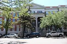
Public schools are operated by Savannah-Chatham County Public Schools.
Libraries
Chatham County's Live Oak Public Libraries constitute a regional library system that provides services to three Georgia counties: Chatham, Effingham, and Liberty. The former name of the system, the Chatham, Effingham, and Liberty County Public Libraries, described this collaboration. In 2002, the name was changed to Live Oak, which reflects the personality of the region, as well as the life and growth of its branches.[15] At the beginning of the 20th century, city leaders in Savannah began to discuss the need for a public library. The history of libraries in Chatham County dates to 1903. According to Geraldine LeMay, former director of the Savannah Public Chatham-Effingham and Liberty Regional Library, the Georgia Historical Society and the city of Savannah worked out a plan that year to establish the Savannah Public Library.[16] The idea was the brainchild of the Georgia Historical Society, which set up a planning committee to determine how the facilities of the society might best be useful to the city of Savannah.[17] In a joint meeting of committee members from the society and the city of Savannah, a free public library was established that would prove to be of great value to the community. This library, however, did not serve citizens of color.
Government and infrastructure
The Coastal State Prison, a Georgia Department of Corrections state prison, is located in Savannah, near Garden City.[18][19]
Chatham County is primarily served by the Chatham County Police Department (CCPD) and the Georgia State Patrol. The Chatham County Sheriff's Office is the enforcement arm of the county court system and operates the county jail.[20] The department was formed on January 1, 2005, when the separate Savannah Police Department and Chatham County Police merged.[21]
Communities
Towns
Census-designated places (unincorporated)
Politics
Chatham County was one of the earliest counties in Georgia to convert from a Solid South voting pattern. From 1952 to 2000, the county went Republican all but four times. Hubert Humphrey carried it by 95 votes in 1968. Jimmy Carter won a majority in both of his runs for president, and in 1996, Bill Clinton became the first non-Georgian Democrat to win a majority since Humphrey.
The county has voted majority Democratic in every presidential election since 2004, when John Kerry carried it by fewer than 150 votes. It swung dramatically to support Barack Obama in 2008, making Obama only the second non-Georgian Democrat to win a majority of the county's vote since Humphrey. Since then, Chatham has tended to vote substantially more for the Democratic Party at the presidential level than the state as a whole. In the last four presidential elections, the Democrats have recorded the biggest margins for a non-Georgian Democrat since Roosevelt's landslides. This culminated in 2020, when Joe Biden took 58.6% of the vote, outdoing Carter's 57% in 1980, because it is a primarily urban county with a large African-American population, especially in its principal city of Savannah. Since 2008, it has been one of the most Democratic urban counties in the state outside of the Atlanta area, and one of the few Democratic pockets in mostly heavily Republican South Georgia.
| Year | Republican | Democratic | Third parties |
|---|---|---|---|
| 2020 | 39.9% 53,232 | 58.6% 78,247 | 1.5% 1,929 |
| 2016 | 40.4% 45,688 | 55.1% 62,290 | 4.5% 5,073 |
| 2012 | 43.4% 47,204 | 55.4% 60,246 | 1.3% 1,371 |
| 2008 | 42.4% 46,829 | 56.8% 62,755 | 0.8% 858 |
| 2004 | 49.6% 45,484 | 49.8% 45,630 | 0.6% 557 |
| 2000 | 49.5% 37,847 | 49.2% 37,590 | 1.4% 1,038 |
| 1996 | 44.9% 31,987 | 50.2% 35,781 | 4.9% 3,509 |
| 1992 | 44.3% 31,925 | 43.8% 31,533 | 11.9% 8,611 |
| 1988 | 58.1% 35,623 | 40.9% 25,063 | 1.0% 603 |
| 1984 | 57.7% 38,482 | 42.4% 28,271 | |
| 1980 | 46.7% 26,499 | 50.0% 28,413 | 3.3% 1,869 |
| 1976 | 43.0% 24,160 | 57.0% 32,075 | |
| 1972 | 71.0% 38,079 | 29.0% 15,566 | |
| 1968 | 33.8% 18,106 | 34.0% 18,201 | 32.2% 17,238 |
| 1964 | 58.9% 33,141 | 41.2% 23,176 | 0.0% 1 |
| 1960 | 52.5% 17,935 | 47.5% 16,240 | |
| 1956 | 62.5% 14,520 | 37.5% 8,698 | |
| 1952 | 51.9% 15,532 | 48.1% 14,370 | |
| 1948 | 25.0% 5,966 | 45.5% 10,864 | 29.6% 7,067 |
| 1944 | 19.1% 2,058 | 80.9% 8,725 | |
| 1940 | 16.5% 1,985 | 83.4% 10,048 | 0.2% 19 |
| 1936 | 10.9% 1,227 | 88.9% 10,019 | 0.2% 24 |
| 1932 | 17.1% 1,669 | 82.3% 8,020 | 0.6% 55 |
| 1928 | 48.9% 5,288 | 51.1% 5,534 | |
| 1924 | 20.4% 1,800 | 69.9% 6,158 | 9.7% 857 |
| 1920 | 19.0% 995 | 81.0% 4,243 | |
| 1916 | 12.9% 616 | 79.4% 3,797 | 7.7% 368 |
| 1912 | 7.5% 332 | 87.1% 3,864 | 5.4% 238 |
| 1908 | 26.5% 1,209 | 72.5% 3,305 | 0.9% 42 |
| 1904 | 12.0% 363 | 87.5% 2,645 | 0.4% 14 |
| 1900 | 21.4% 916 | 78.4% 3,352 | 0.1% 7 |
| 1896 | 35.6% 1,697 | 52.6% 2,506 | 11.7% 558 |
| 1892 | 20.3% 1,359 | 78.8% 5,264 | 0.8% 55 |
| 1888 | 25.4% 1,355 | 73.5% 3,920 | 1.0% 57 |
| 1884 | 35.7% 1,747 | 64.2% 3,144 | |
| 1880 | 38.8% 2,160 | 61.1% 3,404 |
See also
References
- Krakow, Kenneth K. (1975). Georgia Place-Names: Their History and Origins (PDF). Macon, GA: Winship Press. p. 39. ISBN 0-915430-00-2.
- "Census 2010-2020: Counties, Georgia". United States Census Bureau. Retrieved August 23, 2021.
- "State & County QuickFacts". United States Census Bureau. Archived from the original on July 8, 2011. Retrieved May 27, 2020.
- "US Gazetteer files: 2010, 2000, and 1990". United States Census Bureau. February 12, 2011. Retrieved April 23, 2011.
- "Georgia Soil and Water Conservation Commission Interactive Mapping Experience". Georgia Soil and Water Conservation Commission. Retrieved November 22, 2015.
- "U.S. Decennial Census". United States Census Bureau. Retrieved June 17, 2014.
- "Historical Census Browser". University of Virginia Library. Retrieved June 19, 2014.
- "Population of Counties by Decennial Census: 1900 to 1990". United States Census Bureau. Retrieved June 19, 2014.
- "Census 2010-2020: Counties, Georgia". United States Census Bureau. Retrieved August 23, 2021.
- "Explore Census Data". data.census.gov. Retrieved December 14, 2021.
- "DP-1 Profile of General Population and Housing Characteristics: 2010 Demographic Profile Data". United States Census Bureau. Archived from the original on February 13, 2020. Retrieved December 27, 2015.
- "Population, Housing Units, Area, and Density: 2010 - County". United States Census Bureau. Archived from the original on February 13, 2020. Retrieved December 27, 2015.
- "DP02 SELECTED SOCIAL CHARACTERISTICS IN THE UNITED STATES – 2006-2010 American Community Survey 5-Year Estimates". United States Census Bureau. Archived from the original on February 13, 2020. Retrieved December 27, 2015.
- "DP03 SELECTED ECONOMIC CHARACTERISTICS – 2006-2010 American Community Survey 5-Year Estimates". United States Census Bureau. Archived from the original on February 13, 2020. Retrieved December 27, 2015.
- "Library History". Live Oak Public Libraries. Live Oak Public Libraries. Archived from the original on April 10, 2017. Retrieved February 3, 2018.
- LeMay, Geraldine. "HISTORY OF THE SAVANNAH PUBLIC CHATHAM – EFFINGHAM – LIBERTY REGIONAL AND CARNEGIE LIBRARIES 1903 – 1963" (PDF). Live Oak Public Libraries. Live Oak Public Libraries. Archived from the original (PDF) on July 10, 2017. Retrieved March 3, 2018.
- LeMay, Geraldine. "History of the Savannah Public Chathm-Effingham-Liberty Regional and Carnegie Libraries 1903-163" (PDF). Live Oak Public Libraries (LOPL). LOPL. Archived from the original (PDF) on July 10, 2017. Retrieved March 12, 2018.
- "City of Savannah Neighborhoods 2008 Archived September 27, 2011, at the Wayback Machine." City of Savannah. Retrieved on September 15, 2010.
- "Coastal State Prison Archived 2010-09-04 at the Wayback Machine." Georgia Department of Corrections. Retrieved on September 15, 2010.
- "Archived copy". Archived from the original on October 27, 2010. Retrieved August 31, 2010.CS1 maint: archived copy as title (link)
- "Archived copy". Archived from the original on November 30, 2010. Retrieved August 31, 2010.CS1 maint: archived copy as title (link)
- Leip, David. "Dave Leip's Atlas of U.S. Presidential Elections". uselectionatlas.org. Retrieved March 19, 2018.
External links
Places adjacent to Chatham County, Georgia | ||||||||||||||||
|---|---|---|---|---|---|---|---|---|---|---|---|---|---|---|---|---|
| ||||||||||||||||


Municipalities and communities of Chatham County, Georgia, United States | ||
|---|---|---|
| Cities | Map of Georgia highlighting Chatham County | |
| Towns | ||
| CDPs | ||
| Unincorporated communities | ||
| ||


Authority control  | |
|---|---|
| General | |
| National libraries | |
| Other | |