Chefia
Cheffia is a town and commune in El Taref Province, Algeria. According to the 1998 census it has a population of 7,450.[1]
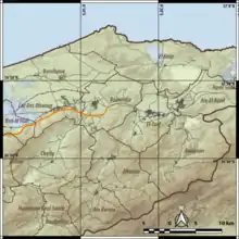
Topographic map of the region around Cheffia
El Cheffia
الشافية El Cheffia | |
|---|---|
Commune and town | |
| Country |  Algeria Algeria |
| Province | El Taref Province |
| Population (1998) | |
| • Total | 7,450 |
| Time zone | UTC+1 (CET) |
The Cheffia valley was described in 1868 by Reboud [2] as being comprised between the eastern slope of the Bou Habet and a series of grassy knolls where a few gardens and clumps of azeroliers stand here and there. It is a valley which measures from north to south about fifteen kilometres and five kilometres wide. It is divided into two basins by the cultivated plateau of Sidi-Bou-Aoun, which has large stones. The Cheffia valley contains a number of ruins that can be considered as Libyan necropolises. Reboud describes a number thereof, and their Lybic insciptions, and published the map shown in this article.
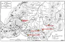
Map showing sites where necropolises have been discovered around Cheffia
References
- Statoids
- Reboud (1870). Paris: Mémoires de la Société française de numismatique et d'archéologie. p. 113. Missing or empty
|title=(help)
Capital: El Taref | ||
| Districts | .svg.png.webp) | |
| Communes | ||
This article is issued from Wikipedia. The text is licensed under Creative Commons - Attribution - Sharealike. Additional terms may apply for the media files.