Chilhowee Mountain
Chilhowee Mountain is the name of two non-contiguous low ridges in the U.S. state of Tennessee. The northern section is located at the outer edge of the Great Smoky Mountains that stretches between the Little Tennessee River (specifically Chilhowee Dam) to the west and the Little Pigeon River watershed to the east, and the southern section is located within the outer edge of the Unicoi Mountains in Polk County. While not entirely within the Great Smoky Mountains National Park, the northernmost mountain's crest is traversed by the westernmost section of Foothills Parkway.
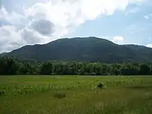
| Chilhowee Mountain | |
|---|---|
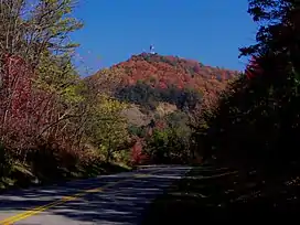 Foothills Parkway approaching Look Rock, on the crest of Chilhowee Mountain | |
| Highest point | |
| Elevation | 2,843 ft (867 m) |
| Coordinates | 35°43′50″N 83°49′12″W |
| Geography | |
| Location | Blount County, Tennessee, U.S. |
| Parent range | Great Smoky Mountains |
| Topo map | USGS Kinzel Springs (TN) |
Background
While the northernmost section is 35 miles (56 km) long, it rarely reaches a width of more than 3 miles (4.8 km) or 4 miles (6.4 km). Little River cuts a large gap in the middle of the mountain (near Walland), dividing it into eastern and western sections. The highest point on the western section is 2,650 ft (808 m) at a knob known as Look Rock. The highest point on the eastern section, known as "The Three Sisters," rises to 2,843 ft (867 m), and is a prominent landmark visible from nearby Maryville, Tennessee.
The southernmost section, located in Polk County, is about 15 miles (24 km) long, and is located entirely within the Cherokee National Forest. The Ocoee River passes along its southern base, along with the Ocoee Scenic Byway, part of U.S. Route 64. The mountain is separated from Oswald Dome to the north by a saddle, although both are technically part of the same ridge. The highest point on this section is 2,618 feet (798 m).[1] The mountain is accessible from US 64 via a paved forest service road, which contains multiple overlooks, and a campround with an artificial lake, operated by the Forest Service, is located atop the mountain. Benton Falls is a waterfall located on the eastern escarpment of the mountain, and is accessible via a trail that begins at the campground.
Chilhowee Mountain derives its name from Chilhowee, a Cherokee village in the 18th century and before that possibly the Creek village called Chalahume by Juan Pardo. In English spelling it has also been written "Chilhoe". The origin of the name is unclear and there are various theories. It is probably derived from Muskogean or Cherokee.[2]
See also
- English Mountain, also on the western edges of the Great Smoky Mountains
- Foothills Parkway
- Cades Cove, a nearby visitor attraction
Bibliography
- Coggins, Allen (1999) [1999]. Place Names of the Smokies. Great Smoky Mtns Natural History Assn. ISBN 978-0937207239.
References
- "Chilhowee Mountain Observation Site Topo Map in Polk County TN". topozone.com. Locality, LLC. Retrieved May 12, 2020.
- Bright, William (2004). Native American Placenames of the United States. University of Oklahoma Press. p. 100. ISBN 978-0-8061-3598-4. Retrieved July 10, 2012.
External links
- "Save Chilhowee Mountain". savechilhoweemountain.org. Archived from the original on October 15, 2008. Retrieved October 15, 2008.
- "Chilhowee Mountain". USGS. Archived from the original on January 2, 2008. Retrieved January 2, 2008.