Districts of Malta
Malta is for non-local government purposes divided into districts as opposed to the local government localities. The three main types of such districts – statistical, electoral at national level, and policing – have no mainstream administrative effect as the local councils form the first-tier – moreover only administrative tier – divisions of the country.
 |
|---|
|
Statistical districts and regions
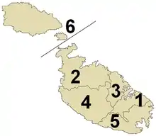
Six districts exist, used for statistical purposes and which are, in turn, grouped into three regions: Gozo, Malta Majjistral and Malta Xlokk. Each district consists of several localities. The Northern Harbour District, Western District and Northern District together form the North Western Region (Malta Majjistral). The South Eastern District and Southern Harbour District form the South Eastern Region (Malta Xlokk). The Gozo and Comino District is a Region in its own right.[1]
Southern Harbour District
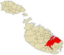
The Southern Harbour District forms part of Malta Xlokk. It contains 14 local councils including the all but western suburbs of the capital Valletta and the small cities Birgu, Cospicua, Senglea and Żabbar. Its largest locality is Żabbar; its smallest, Xgħajra.[1] The District's population is 80,170 (as of 31 December 2016) across its 26.1 km2. Thus it then ranked second-most populous and had the fifth-largest extent.
- Birgu (Vittoriosa) 2,451 population (at end 2016)
- Bormla (Cospicua) 5,147
- Fgura 11,714
- Floriana (Furjana) 1,966
- Senglea (Isla) 2,691
- Kalkara 3,006
- Luqa, include the hamlet of Ħal Farruġ 5,793
- Marsa (both parishes; the Parish of the Holy Trinity and the Parish of Maria Regina) 5,328
- Paola (Paola) (both parishes; the Parish of Christ the King and the Parish of Our Lady of Lourdes) 8,241
- Santa Luċija 2,929
- Tarxien 8,674
- Valletta (the three parishes; the Parish of Our Lady of Porto Salvo, the Parish of St. Paul's Shipwreck and the Parish of St. Augustine) 5,656
- Xgħajra 1,673
- Żabbar, include the hamlet of St. Peter's[1] 14,901
Northern Harbour District
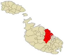
The Northern Harbour District forms part of the Central Region. It contains 13 local councils including the city of Qormi, with the largest locality being Birkirkara (pop. 22,314). The smallest one is Ta' Xbiex (pop. 1,657). The population of the District is 131,056 (as of 31 December 2016) across its 24.1 km2. It is the most populous and yet the smallest.
- Birkirkara (include the hamlets of Fleur-de-Lys (Parish of Our Lady of Carmelo) and Is-Swatar (Parish of St. George Preca) and the Parish of St. Helen, the Parish of St. Joseph the Worker and the Parish of St. Mary)
- Il-Gżira
- Il-Ħamrun (both parishes; the Parish of St. Cajtan and the Parish of Immaculate Conception)
- L-Imsida
- Pembroke
- Tal-Pietà (include the hamlet of Guardamangia)
- Ħal Qormi (both parishes; the Parish of St. George and the Parish of St. Sebastian)
- San Ġiljan (include the hamlet of Paceville and the parish area of Balluta Bay)
- San Ġwann (include the hamlet of Il-Kappara)
- Santa Venera
- Tas-Sliema (the four parishes; the Parish of Stella Maris, the Parish of Sacro Cour, the Parish of St. Gregory and the Parish of Jesus of Nazareth)
- Is-Swieqi (include the hamlet of Madliena)
- Ta' Xbiex
South Eastern District
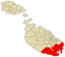
The South Eastern District forms part of Malta Xlokk. It contains 11 local councils including the city of Żejtun, with the largest locality being Marsaskala (pop. 12,281) while the smallest one is Ħal Safi (pop. 2,168). The population of the District is 68,044 (as of 31 December 2016) across its 54.3 km2. It is the fourth-largest district by population and area.
- Birżebbuġa
- Ħal Għaxaq
- Il-Gudja
- Ħal Kirkop
- Marsaskala (Wied il-Għajn)
- Marsaxlokk
- L-Imqabba
- Il-Qrendi
- Ħal Safi
- Iż-Żejtun
- Iż-Żurrieq (include the hamlet of Bubaqra)
Western District
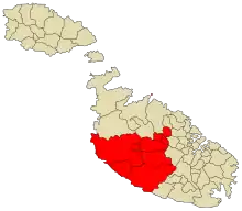
The Western District forms part of Malta Majjistral. It contains 10 local councils including the cities of Mdina, Siġġiewi and Żebbuġ, the most populous locality being Żebbuġ (pop. 11,759). The smallest one is Mdina (pop. 229). The population of the District is 59,817 (as of 31 December 2016) across its 72.5 km2. Thus it was the fifth-largest by population and has the second-largest extent.
- Ħ'Attard
- Ħal Balzan
- Ħad-Dingli
- L-Iklin
- Ħal Lija
- L-Imdina
- L-Imtarfa
- Ir-Rabat (include the hamlets of Baħrija and Tal-Virtù)
- Is-Siġġiewi
- Ħaż-Żebbuġ
Northern District
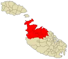
The Northern District forms part of the Northern Region. It contains 6 local councils but no cities, with the largest locality being St. Paul's Bay (pop. 29,843); its smallest is Għargħur (pop. 2,743). The population of the District is 69,467 (as of 31 December 2016) across its 73.6 km2. It is the third most populous and is the largest.
- Ħal Għargħur
- Il-Mellieħa (include the parish area of Manikata)
- L-Imġarr
- Il-Mosta
- In-Naxxar (include the hamlet of Baħar iċ-Ċagħaq)
- San Pawl il-Baħar (include the hamlet of Burmarrad (Parish of the Sacred Heart of Our Lady) and the Parish of Our Lady of Sorrows and the Parish of St. Frances at Qawra)
Gozo and Comino District
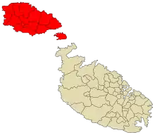
The Gozo and Comino District is also the Gozo Region. It contains 14 local councils including the city of Victoria (or Rabat). This is also the largest locality (pop. 6,211) while the smallest one is Għasri (pop. 418). The population of the District is 31,879 (as of 31 December 2016) across its 68.7 km2. It is the least populous district and the third biggest.
Electoral districts
There are currently 13 Electoral Divisions for the unicameral (single-assembly) parliament. Each consists of a number of localities (although there is no requirement that electoral boundaries follow the boundaries of localities).[2][3]
District 2
- Il-Birgu
- L-Isla
- Bormla
- Ħaż-Żabbar (including St. Peter's)
- Il-Kalkara
- Ix-Xgħajra
- Il-Fgura (Tal-Gallu area)
District 4
- Il-Fgura (Mater Boni Consigli and Tal-Liedna areas)
- Il-Gudja
- Paola
- Santa Luċija
- Ħal Tarxien
District 5
- Birżebbuġa
- Ħal Kirkop
- L-Imqabba
- Ħal Farruġ
- Il-Qrendi
- Ħal Safi
- Iż-Żurrieq (including Bubaqra)
District 7
- Ħad-Dingli
- L-Imġarr
- L-Imtarfa
- Ir-Rabat (including Il-Baħrija and Tal-Virtù)
- Ħaż-Żebbuġ
District 8
- Birkirkara (including Fleur-de-Lys and part of Swatar)
- L-Iklin
- Ħal Lija
- Ħal Balzan
District 9
- Ħal Għargħur
- L-Imsida (including part of Swatar)
- San Ġwann (including Il-Kappara)
- Is-Swieqi (including Tal-Ibraġ and Il-Madliena)
- Ta' Xbiex
District 10
- Il-Gżira
- Pembroke
- San Ġiljan (including Paceville)
- Tas-Sliema
- In-Naxxar (San Pawl tat-Tarġa, Birguma, Magħtab and Salina areas)
- Baħar iċ-Ċagħaq
District 12
- Il-Mellieħa (including Il-Manikata)
- In-Naxxar (Church area)
- San Pawl il-Baħar
District 13
This district consists of the islands of Gozo and Comino
- Ir-Rabat (Victoria)
- Il-Fontana
- Għajnsielem (including Comino)
- L-Għarb
- L-Għasri
- Ta' Kerċem (including Santa Luċija)
- Il-Munxar
- Ix-Xlendi
- In-Nadur
- Il-Qala
- San Lawrenz
- Ta' Sannat
- Ix-Xagħra
- Ix-Xewkija
- Iż-Żebbuġ (including Marsalforn)
Police districts
There are 11 police districts, each having its own police headquarters.
District 1
- Il-Belt Valletta, Archbishop Street
- Il-Furjana, St. Anne Str
- Pinto Police, Valletta Waterfront
- Headquarters in Valletta, the capital city of Malta.
District 2
- Ħal Qormi Main Street
- Ħaż-Żebbuġ Parish Street
- Is-Siġġiewi St. Nicholas Square
- Għar Lapsi
- Headquarters in Qormi Città Pinto
District 3
- Paola, Valletta Road
- Il-Fgura, Hompesch Road
- Ħal Tarxien, Nelson Avenue
- Ħal Luqa and Ħal Farruġ St. Andrew Square
- Santa Luċija, Tower Promenade
- Headquarters in Paola (Raħal Ġdid)
District 4
- Bormla St. Paul's Street
- Ħaż-Żabbar and St. Peter's, Triq iċ-Ċawsli
- Il-Kalkara, Archbishop Gonzi Square
- L-Isla, 4 September Street
- Il-Birgu, Desain Street
- Ix-Xgħajra, Church Street
- Marsaskala, Żonqor Road
- Headquarters in Bormla Città Cospicua
District 5
- Iż-Żejtun, Mater Boni Consiglii Street
- Il-Gudja, Raymond Caruana Street
- Ħal Għaxaq, Labour Avenue
- Birżebbuġa, Pretty Bay
- Marsaxlokk, Fishermen's Strand
- Iż-Żurrieq and Bubaqra, St. Catherine Street
- Wied iż-Żurrieq
- Il-Qrendi, Church Street
- L-Imqabba, Parish Street
- Ħal Kirkop, St. Benedict Street
- Ħal Safi, St. Paul's Street
- Headquarters in Iż-Żejtun Città Beland
District 6
- Tas-Sliema, Rudolph Street
- Il-Gżira, Belvedere Street
- L-Imsida and Ta' Xbiex, Rue d'Argens
- Headquarters in Tas-Sliema
District 6A
- San Ġiljan, Paceville, and Pembroke, St. George's Road, Spinola Bay
- Is-Swieqi and Il-Madliena,
- San Ġwann, Naxxar Road
- Headquarters in San Giljan
District 7
- Il-Ħamrun, St. Paul's Square
- Il-Marsa, Balbi Street
- Santa Venera, St. Joseph High Road
- Ir-Rabat, Il-Baħrija and Tal-Virtù, St. Rita Street
- Ħad-Dingli, Main Street
- L-Imdina, St. Publius Square
- L-Imtarfa, Maltese Regiments Street
- Headquarters in Ħamrun
District 8
- Birkirkara, Fleur-de-Lys and Is-Swatar, Main Street
- Ħal Balzan, Ħal Lija and L-Iklin, Bertu Fenech Square (Balzan)
- Ħ'Attard, Main Street
- In-Naxxar and Baħar iċ-Ċagħaq, Żenqa Street
- Ħal Għargħur, St. Albert Street
- Ta' Qali, Pitkalija
- Headquarters in Birkirkara, the largest locality in Malta
District 9
- Il-Mosta, Constitution Street
- L-Imġarr, Fisher Street
- San Pawl il-Baħar and Burmarrad, St. Paul's Street
- Il-Qawra, Tourist Street
- Il-Mellieħa, Parish Square
- Iċ-Ċirkewwa, Ċirkewwa Terminal
- L-Għadira
- Headquarters in Il-Mosta, the second largest locality in Malta.
District 10
- Kemmuna, Congrave Street
- Il-Fontana, Ta' Mulejja Street
- Għajnsielem, Simirat Street
- L-Għarb, Church Street
- L-Għasri, Saviour Square
- Ta' Kerċem and Santa Luċija, Sarġ Street
- Marsalforn, Marina Street
- Il-Port tal-Imġarr, Coast Road
- Il-Munxar, Munxar Road
- In-Nadur, Saints Peter and Paul Square
- Il-Qala, St. Joseph Street
- Ramla Bay
- San Lawrenz, St. Lawrence Square
- Ta' Sannat, Sannat Road
- Ta' Pinu
- Ix-Xagħra, 8 September Avenue
- Ix-Xewkija, Independence Street
- Ix-Xlendi, St. Andrew Street
- Iż-Żebbuġ, Church Street
- Ir-Rabat, Għawdex (Victoria), Republic Street
- Gozo Fire Brigade
- Headquarters in Ir-Rabat, Għawdex (Victoria), capital city of Gozo
References
- Saviour Formosa; Sandra Scicluna; Jacqueline Azzopardi, eds. (January 2013). Realities of Crime, Society and Landuse in the Mediterranean: JANUS I (PDF). Msida: Department of Criminology, University of Malta. pp. 59–60. doi:10.13140/2.1.1230.4322. ISBN 978-99957-834-0-2. Archived from the original on 15 March 2017.
- Gauci, Salv. (23 April 2012). "Constitution of Malta. Article 61 – Electoral Divisions" (PDF). The Malta Government Gazette (18904). Retrieved 26 August 2014.
- "Electoral Divisions". Electoral Commission Malta. Retrieved 30 January 2019.
 |
Wikimedia Commons has media related to Districts of Malta. |