Tornado outbreak sequence of April 2–5, 1957
On April 2–5, 1957, a deadly tornado outbreak sequence struck most of the Southern United States. The outbreak killed at least 21 people across three states and produced at least 72 tornadoes from Texas to Virginia. The outbreak was most notable due to a tornado that hit a densely populated area of the Dallas–Fort Worth metropolitan area, killing 10 people and injuring 200 or more. The tornado, highly visible for most of its path, was at the time the most observed and best-documented tornado in recorded history; hundreds of people photographed or filmed the F3 tornado as it moved just west of Downtown Dallas. The film of this tornado is still known for its unusually high quality and sharpness, considering the photography techniques and technology of the 1950s. Damage from the Dallas tornado reached as high as $4 million (1957 USD). Besides the famous Dallas tornado, other deadly tornadoes struck portions of Mississippi, Texas, and Oklahoma. Two F4 tornadoes struck southern Oklahoma on April 2, killing five people. Three other significant, F2-rated tornadoes that day killed two people in Texas and one more in Oklahoma. An F3 tornado struck rural Mississippi on April 4, killing one more person.[nb 2][nb 3][nb 4]
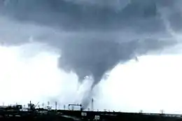 The 1957 Dallas tornado exhibiting multiple vortices on April 2 | |
| Type | Tornado outbreak sequence |
|---|---|
| Duration | April 2–5, 1957 |
| Highest gust | 83 kn (96 mph; 154 km/h) in Toledo, Ohio, on April 5[1][2] |
| Tornadoes confirmed | 72 confirmed |
| Max. rating1 | F4 tornado |
| Duration of tornado outbreak2 | 3 days, 16 hours, 35 minutes |
| Largest hail | 2+1⁄2 in (6.4 cm) in Oklahoma on April 2[3] |
| Fatalities | 21 fatalities, 338 injuries |
| Damage | $9.562 million (1957 USD)[nb 1][4] $88.1 million (2021 USD) |
| Areas affected | Central and Eastern United States |
Part of the tornadoes and tornado outbreaks of 1957 1Most severe tornado damage; see Fujita scale 2Time from first tornado to last tornado | |
Background
At 6:30 a.m. CST (12:30 UTC) on Tuesday, April 2, 1957, a low-pressure system was situated over the Texas and Oklahoma panhandles, with a warm front stretching into northern Louisiana and a cold front stretching along a surface-based trough into western Texas east of El Paso, Lubbock, and Amarillo. Temperatures on that day reached the 70s in northern Texas with dew points in the upper 60s to near 70 °F (21 °C). A strong upper-level jet, abundant instability in the atmosphere, and substantial wind shear provided additional fuel for the development of supercells across the region, particularly along and just north of the warm front. A capping inversion also helped maintain lifted indices of up to -71⁄2 through late afternoon, contributing to high convective available potential energy (CAPE) for severe thunderstorm development and tornadogenesis.[14]
Outbreak statistics
| State | Total | County | County total |
|---|---|---|---|
| Mississippi | 1 | Smith | 1 |
| Oklahoma | 6 | Bryan | 3 |
| Marshall | 2 | ||
| Murray | 1 | ||
| Texas | 12 | Dallas | 10 |
| Delta | 1 | ||
| Lamar | 1 | ||
| Totals | 19 | ||
| All deaths were tornado-related | |||
Confirmed tornadoes
| FU | F0 | F1 | F2 | F3 | F4 | F5 | Total |
|---|---|---|---|---|---|---|---|
| 0 | 17 | 21 | 26 | 6 | 2 | 0 | ≥ 72 |
- In addition to confirmed tornadoes, a possible tornado may have destroyed a home in the Woodlawn community, near Sherman, on April 2. Another possible tornado hit Ballard County, Kentucky, on April 3, unroofing homes, destroying a drive-in theater, and uprooting trees. A loud roaring noise was heard. Another tornado may have also struck near Tansill in Pope County, Illinois, on the same date. Another Two other brief tornadoes may have hit near Westlake and at Tallulah, Louisiana, late on April 4.[15]
April 2 event
| F# | Location | County / Parish | State | Start coord. |
Time (UTC) | Path length | Max. width | Summary |
|---|---|---|---|---|---|---|---|---|
| F2 | ESE of Allison | Cooke | TX | 33.25°N 97.38°W | 09:00–? | 0.1 miles (0.16 km) | 33 yards (30 m) | Tornado reported. Losses were unknown. Tornado researcher Thomas P. Grazulis did not classify the tornado as an F2 or stronger.[17][18][19] |
| F2 | SE of Howe | Grayson | TX | 33.47°N 96.58°W | 21:00–? | 0.1 miles (0.16 km) | 33 yards (30 m) | Tornado destroyed or damaged three homes, including a farmhouse, and blew cars off a road. Barns were also destroyed, and many trees were blown down. A couple were moved 50 yd (150 ft), critically injuring the woman. One other person was injured and losses totaled $25,000. Tornado may have been part of the same family as the Melissa–Anna–Van Alstyne F3.[20][21][22] |
| F2 | WSW of Rowland | Montague | TX | 33.93°N 97.72°W | 21:25–? | 2 miles (3.2 km) | 33 yards (30 m) | Short-lived tornado destroyed a church, a warehouse, and three houses. One woman was mildly injured when the roof over her head collapsed. Losses totaled $25,000.[23][21][22] |
| F1 | NNE of Ringling | Jefferson | OK | 34.22°N 97.58°W | 21:30–? | 2 miles (3.2 km) | 33 yards (30 m) | Short-lived tornado destroyed or damaged several farmsteads. Losses totaled $2,500.[24][21] |
| F0 | NNE of Grapevine | Tarrant | TX | 32.97°N 97.05°W | 21:50–? | 0.3 miles (0.48 km) | 67 yards (61 m) | Brief touchdown produced minimal damage. Losses totaled $2,500.[25][21] |
| F0 | SW of Pottsboro | Grayson | TX | 33.72°N 96.7°W | 22:00–? | 0.1 miles (0.16 km) | 33 yards (30 m) | Brief tornado destroyed or damaged three homes and numerous barns. Losses totaled $25,000. Grazulis listed the tornado as an F3 with a 5-mile-long (8.0 km) path length.[26][21][22] |
| F3 | Melissa to Anna to Van Alstyne | Collin, Grayson | TX | 33.28°N 96.62°W | 22:20–? | 10.7 miles (17.2 km) | 33 yards (30 m) | Intense tornado family comprised two distinct events, the first of which destroyed or damaged approximately 25 homes and barns, along with a church, a porch, and a warehouse, in and near Melissa, scattering debris for 3 mi (4.8 km). Second member of the family destroyed eight homes in Anna and left debris in Van Alstyne. Four people were injured and losses totaled $500,000. First member may have touched down at two locations east of McKinney.[27][28][21][21][22] |
| F3 | Western Dallas | Dallas | TX | 32.85°N 96.83°W | 22:30–23:10 | 17.2 miles (27.7 km) | 100 yards (91 m) | 10 deaths – See section on this tornado – At least 200 people were injured and losses totaled $2.5 million.[29][21][22] |
| F2 | SE of Davis to S of Stratford | Murray, Garvin | OK | 34.55°N 96.9°W | 22:50–? | 11.7 miles (18.8 km) | 400 yards (370 m) | Pair of tornadoes, paralleling each other within 2 mi (3.2 km), destroyed or damaged 28 barns and homes, carrying papers 40 mi (64 km) distant. A farmstead was nearly leveled at Corley, 3 mi (4.8 km) outside Stratford. One person—possibly two—was injured and losses totaled $50,000. Grazulis listed the tornado as a high-end F3, based on damage to three homes. NCEI lists the touchdown as west of Hickory.[30][31][32][22] |
| F2 | W of Dougherty | Murray | OK | 34.4°N 97.13°W | 22:55–? | 2 miles (3.2 km) | 600 yards (550 m) | 1 death – Large, intense tornado crossing U.S. Route 77 in the Arbuckle Mountains south of Davis threw a pickup truck 75 yd (225 ft), killing the driver, and also tossed a car 300 yd (900 ft). A 340-to-360-foot-tall (100 to 110 m) telecommunications tower was destroyed, and a television transmission center lost its roof. Two people were injured and losses totaled $250,000. Grazulis listed the tornado as an F3.[33][34][35] |
| F4 | N of New Woodville | Marshall | OK | 34°N 96.65°W | 23:29–? | 5.2 miles (8.4 km) | 200 yards (180 m) | 2 deaths – Violent tornado touched down over Lake Texoma, destroying or severely damaging 15 homes, a pair of oil refineries, and a fishing camp. A pair of large homes were swept away, and a car was tossed 200 ft (61 m) as well, resulting in a fatality and injury. Six people were injured and losses totaled $2.5 million.[36][34][35] |
| F4 | Calera to Durant to SW of Armstrong | Bryan | OK | 33.93°N 96.43°W | 23:58–? | 7.9 miles (12.7 km) | 200 yards (180 m) | 3 deaths – Violent tornado destroyed a large barn and a drive-in theater in Calera (parodying a scene in the 1996 film Twister). Tornado also destroyed or damaged 160 businesses and homes in 29 blocks of Durant, along with a service station and nearly every building at Southeastern State College, now Southeastern Oklahoma State University. Three people were injured and losses totaled $500,000. Precursor to tornado was first observed as a funnel cloud near Denison, Texas.[37][34][38] |
| F2 | Ambia | Lamar | TX | 33.48°N 95.77°W | 00:00–? | 6.5 miles (10.5 km) | 100 yards (91 m) | 1 death – Tornado destroyed a pair of homes, fatally crushing a man beneath debris. About seven other homes were destroyed nearby. Two people were injured and losses totaled $25,000. NCEI lists the path as extending from Ben Franklin to north of Roxton.[39][34][35] |
| F2 | Northern Wheeler | Wheeler | TX | 35.45°N 100.27°W | 00:05–? | 0.3 miles (0.48 km) | 33 yards (30 m) | Brief but strong tornado killed livestock, swept away a barn, damaged outbuildings, and severely damaged a farmhouse. Losses totaled $25,000.[40][34][38] |
| F3 | Dido to Newark | Tarrant, Wise | TX | 33.03°N 97.55°W | 00:15–00:40 | ≥0.1 miles (0.16 km) | 33 yards (30 m) | Intense tornado destroyed or damaged numerous structures, including 11 homes, one of which was tossed 70 ft (21 m). A school lost its roof, school buses were tossed, a community centre made of sheet metal was flattened, and National Guard buildings were damaged. Two people were injured and losses totaled $250,000. Grazulis listed the tornado as a 9-mile-long (14 km) F2. NCEI lists the touchdown as north of Briar.[41][34][38] |
| F2 | E of Altus to W of Mountain View | Jackson, Kiowa | OK | 34.63°N 99.27°W | 00:30–? | 43.7 miles (70.3 km) | 150 yards (140 m) | Long-tracked tornado skipped past Friendship and Roosevelt, wrecking a truck and several barns. A home lost its roof as well. One person was injured and losses totaled $50,000.[42][43][34][38] |
| F2 | SE of Harmon | Lamar | TX | 33.5°N 95.8°W | 00:30–? | 0.1 miles (0.16 km) | 33 yards (30 m) | Brief but strong tornado struck the rural K-Bar Ranch, severely damaging an arena and outbuildings. Farm machinery, a garage, and a home received lesser damage, while another home was destroyed. Losses totaled $25,000.[44][34] |
| F1 | ENE of Stony to Plainview | Denton | TX | 33.23°N 97.33°W | 00:30–? | 1.5 miles (2.4 km) | 67 yards (61 m) | Tornado produced three distinct swaths of intermittent damage, including to outbuildings and a few barns. A home was partly unroofed as well. Losses totaled $25,000.[45][34] |
| F0 | W of Asher | Pottawatomie | OK | 34.98°N 96.95°W | 00:40–? | 0.1 miles (0.16 km) | 33 yards (30 m) | Brief touchdown reported. Losses totaled $30.[46][47] |
| F0 | S of Altus to ESE of Friendship | Jackson | OK | 34.6°N 99.32°W | 01:05–? | 8.8 miles (14.2 km) | 100 yards (91 m) | Second Altus-area tornado hit the eastern side of Altus Air Force Base and moved into rural areas. Losses totaled $25,000.[48][47] |
| F1 | SE of Grant to ESE of Spencerville | Choctaw | OK | 33.93°N 95.5°W | 01:15–? | 16.8 miles (27.0 km) | 33 yards (30 m) | Tornado passed east of Hugo, destroying or damaging several barns and homes. Losses totaled $25,000. Grazulis listed the tornado as an F2.[49][47][38] |
| F2 | Ben Franklin | Delta | TX | 33.55°N 95.77°W | 01:51–? | 0.1 miles (0.16 km) | 33 yards (30 m) | 1 death – Tornado destroyed six homes and damaged several others. Two people were injured and losses totaled $25,000. This and the previous event may have belonged to the same family. Grazulis listed the tornado as the same as the Ambia–Harmon F2s, considering all three to be a 30-mile-long (48 km) F3 event.[50][18][35] |
| F2 | W of Bengal to McCurtain | Latimer, Haskell | OK | 34.83°N 95.1°W | 03:00–? | 23.3 miles (37.5 km) | 880 yards (800 m) | Tornado bypassed Salonia and Red Oak, destroying or damaging several stores, an old high school, and 28 homes. Two people were injured and losses totaled $50,000.[51][52][47][38] |
| F2 | Northwestern Hartshorne to N of Patterson | Pittsburg, Latimer | OK | 34.85°N 95.57°W | 03:05–? | 11.7 miles (18.8 km) | 440 yards (400 m) | Tornado struck Haileyville, destroying a barn and tearing the roofs off a drugstore and two other businesses. More than 100 television antennae were snapped, and many trees were felled as well. Losses totaled $25,000.[53][47][38] |
| F1 | ESE of Stephens Gap | McCurtain | OK | 34.13°N 94.65°W | 03:30–? | 11.2 miles (18.0 km) | 880 yards (800 m) | Nocturnal tornado east of Beavers Bend Resort Park destroyed 3,000,000 board feet (7,100 m3) of timber near Carnasaw Tower in the Ouachita National Forest. Losses totaled $25,000.[54][18] |
| F0 | Western Poteau | Le Flore | OK | 35.05°N 94.63°W | 03:50–? | 0.1 miles (0.16 km) | 33 yards (30 m) | Little or no damage reported. Losses totaled $30.[55][47] |
| F0 | Northern Oklahoma City | Oklahoma | OK | 35.6°N 97.55°W | 04:30–? | 0.1 miles (0.16 km) | 33 yards (30 m) | 30-foot-wide (9.1 m) swaths of grain standing in a field were flattened near The Village. Losses totaled $30.[56][47] |
April 3 event
| F# | Location | County / Parish | State | Start coord. |
Time (UTC) | Path length | Max. width | Summary |
|---|---|---|---|---|---|---|---|---|
| F1 | SW of Courtney | Love | OK | 33.93°N 97.52°W | 05:45–? | 0.1 miles (0.16 km) | 33 yards (30 m) | Tornado swept away a home. Losses were unknown. Many tornadoes were reported nearby.[57][18] |
| F0 | Northern Davenport | Lincoln | OK | 35.72°N 96.77°W | 06:15–? | 0.1 miles (0.16 km) | 33 yards (30 m) | Funnel was observed aloft and later confirmed to have been a tornado. Losses totaled $30.[58][18] |
| F0 | Northern Terrell | Kaufman | TX | 32.75°N 96.28°W | 07:15–? | 0.1 miles (0.16 km) | 33 yards (30 m) | Brief touchdown reported. Losses were unknown.[59][60] |
| F1 | SSW of Woodlawn (1st tornado) | Harrison | TX | 32.62°N 94.38°W | 16:28–? | 0.1 miles (0.16 km) | 33 yards (30 m) | Brief touchdown. Losses totaled $30.[61][18] |
| F0 | W of Parvin | Denton | TX | 33.25°N 96.95°W | 16:30–? | 0.1 miles (0.16 km) | 33 yards (30 m) | Tornado hit an open field, causing only $30 in losses.[62][18] |
| F0 | Southern Fort Worth | Tarrant | TX | 32.67°N 97.33°W | 16:45–? | 0.1 miles (0.16 km) | 33 yards (30 m) | Losses totaled $30.[63][18] |
| F0 | Western Duncanville | Dallas | TX | 32.65°N 96.92°W | 16:50–? | 0.1 miles (0.16 km) | 33 yards (30 m) | Tornado damaged a single home. Losses totaled $250.[64][60] |
| F2 | W of Lone Star | Morris | TX | 32.88°N 94.72°W | 17:00–? | 0.1 miles (0.16 km) | 33 yards (30 m) | Tornado destroyed a structure and damaged six outbuildings on a farm. Losses totaled $250. Grazulis did not list the tornado as an F2 or stronger.[65][18][19] |
| F2 | SSW of Woodlawn (2nd tornado) | Harrison | TX | 32.62°N 94.38°W | 17:30–? | 0.1 miles (0.16 km) | 33 yards (30 m) | Tornado partly unroofed a home, damaged a pair of outbuildings, destroyed a shed, and downed trees. Losses totaled $2,500. Grazulis did not list the tornado as an F2 or stronger.[66][18][19] |
| F1 | ESE of Caruth | Dunklin | MO | 36.13°N 90.08°W | 18:00–18:10 | 1 mile (1.6 km) | 100 yards (91 m) | Tornado damaged several structures and a cotton gin. Losses totaled $2,500.[67][68] |
| F2 | Alexander | Greene | AR | 36.07°N 90.42°W | 18:05–? | 0.1 miles (0.16 km) | 33 yards (30 m) | Brief tornado destroyed a garage. Losses totaled $250. Grazulis did not list the tornado as an F2 or stronger. NCEI lists the touchdown as east-northeast of Morning Star.[69][68][19] |
| F3 | ENE of Cash to N of Finch | Craighead, Greene | AR | 35.8°N 90.92°W | 18:05–? | 22.6 miles (36.4 km) | 100 yards (91 m) | Intense tornado badly damaged a rice dryer and wrecked many structures. Losses totaled $25,000. Grazulis did not list the tornado as an F2 or stronger.[70][68][19] |
| F1 | Manila | Mississippi | AR | 35.8°N 90.17°W | 18:30–? | 0.1 miles (0.16 km) | 33 yards (30 m) | Brief tornado damaged a pair of homes. Losses totaled $250. NCEI lists the touchdown as north-northeast of Floodway.[71][68] |
| F1 | Little Cypress | Orange | TX | 30.1°N 93.73°W | 18:45–? | 0.1 miles (0.16 km) | 33 yards (30 m) | Tornado ripped a 50-by-40-foot (15 by 12 m) portion of a roof off a school. Losses totaled $250. NCEI lists the touchdown as near downtown Orange.[72][68] |
| F0 | E of Dogwood | Mississippi | MO | 36.83°N 89.4°W | 19:30–19:35 | 0.3 miles (0.48 km) | 10 yards (9.1 m) | Tornado damaged outbuildings on a farm. Losses totaled $2,500.[73][68] |
| F2 | Hurstown | Shelby | TX | 31.62°N 94.05°W | 19:30–? | 2 miles (3.2 km) | 33 yards (30 m) | Brief but strong tornado destroyed a pair of barns and a small home. Losses totaled $2,500. NCEI lists the touchdown as northwest of Hawthorne.[74][68][38] |
| F2 | Cairo to Mound City | Alexander, Pulaski | IL | 37°N 89.2°W | 20:00–? | 6.8 miles (10.9 km) | 33 yards (30 m) | Tornado affected a two-block-wide swath, unroofing three large buildings. Five people were injured and losses totaled $250,000. Grazulis did not list the tornado as an F2 or stronger.[75][76][68][19] |
| F1 | E of Woodburn | Warren | KY | 2330 | 0.1 miles (0.16 km) | A funnel cloud was observed and later confirmed to be a touchdown.[4][77] | ||
| F0 | Jonesboro | Jackson | LA | 0000 | 0.5 miles (0.80 km) | A brief touchdown near Hodge caused minor damage.[4] | ||
| F1 | SW of Hollandale | Washington | MS | 0115 | 11.9 miles (19.2 km) | A tornado damaged or destroyed 20 homes. It also destroyed and scattered a church and a cotton gin. Grazulis listed the tornado as an F2.[38] |
April 4 event
| F# | Location | County / Parish | State | Start coord. |
Time (UTC) | Path length | Max. width | Summary |
|---|---|---|---|---|---|---|---|---|
| F2 | NE of Vernon to W of Forreston | Winston, Noxubee, Lowndes | MS | 0615 | 40.7 miles (65.5 km) | A tornado destroyed rural farms and outbuildings.[38] | ||
| F3 | Sanatorium to SW of Penantly | Simpson, Smith, Jasper | MS | 0700 | 40.2 miles (64.7 km) | 1 death – This tornado first struck the Mississippi Tuberculosis Sanatorium (now Boswell Regional Center), injuring 30 of 200 patients in a dormitory. Nearby, the tornado also damaged or destroyed 10 homes. West of Bay Springs, the tornado killed a person and injured 15 others who had sought shelter in a school bus. The tornado also struck the rural "Ted" and "Warren Hill" communities, near the Smith–Jasper county line, before dissipating.[4][38] | ||
| F2 | SE of Middle Fork | Henderson | TN | 0710 | 0.1 miles (0.16 km) | This brief tornado destroyed two homes. It also damaged four other homes and numerous barns.[38] | ||
| F3 | SE of Ramer to Eastview to NE of Gravel Hill | McNairy | TN | 0715 | 7.3 miles (11.7 km) | This tornado destroyed nine homes and nine barns. It also damaged 13 other homes. The tornado was rated F2 by Grazulis.[38] | ||
| F1 | SE of Lonoke | Lonoke | AR | 2330 | 0.3 miles (0.48 km) | A tornado damaged 20 acres (8.1 ha), destroying a grain bin and knocking down fences and light poles.[4] |
April 5 event
| F# | Location | County / Parish | State | Start coord. |
Time (UTC) | Path length | Max. width | Summary |
|---|---|---|---|---|---|---|---|---|
| F0 | Barnesville | Lamar | GA | 0800 | 1.3 miles (2.1 km) | A tornado damaged utility lines and trees in Barnesville. Several barns were reported destroyed, and porches were blown away as well.[4] | ||
| F2 | SW of Ellaville to S of Gordon | Schley, Macon, Peach, Houston, Twiggs, Wilkinson | GA | 0900 | 75 miles (121 km) | 2 deaths – A family of three or more tornadoes began with an F2 touchdown near Ellaville, damaging or destroying 85 homes across Schley County. Two children died near the border of Macon County, and 37 homes were damaged or destroyed in the "Lowe" community. In Twiggs County, another F2 touchdown leveled a small home near Jeffersonville. A third, weaker touchdown in Wilkinson County damaged roofs and uprooted trees.[4][38] | ||
| F2 | Thomson to SW of Appling | Warren, McDuffie, Columbia | GA | 1200 | 23.3 miles (37.5 km) | This family of three or more tornadoes may have begun southwest of Warrenton, where homes and barns were destroyed, but is officially plotted as having started near Thomson, where more homes and barns were destroyed at F2 intensity. In "Leah", a second F2 tornado touched down, destroying a church and seven homes. A third F2 touchdown destroyed a home in the "Pumpkin Hill" community between Appling and Harlem.[38] | ||
| F2 | E of Monetta to N of Lexington | Lexington | SC | 1245 | 21.3 miles (34.3 km) | One home was destroyed and several others were damaged. A large recreation hall was badly damaged.[4] | ||
| F1 | Prosperity | Newberry | SC | 1314 | 3.3 miles (5.3 km) | |||
| F0 | E of Moultrie to NW of Sparks | Colquitt, Cook | GA | 1330 | 13.7 miles (22.0 km) | A tornado destroyed homes and two barns. Trees were uprooted as well.[4] | ||
| F1 | N of Waycross | Ware | GA | 1600 | 0.1 miles (0.16 km) | A tornado destroyed one home and damaged trees and other structures in "Jamestown", near Blackshear.[4] | ||
| F0 | Hutchinson Island | Chatham | GA | 1634 | 0.3 miles (0.48 km) | A tornado damaged roofs and small structures. Many trees were uprooted as well.[4] | ||
| F1 | SW of Union City | Randolph | IN | 1800 | 0.1 miles (0.16 km) | |||
| F2 | Muncie | Delaware | IN | 1805 | 0.1 miles (0.16 km) | |||
| F0 | NE of Fairmount | Grant | IN | 1830 | 0.1 miles (0.16 km) | |||
| F2 | NW of Heltonville | Lawrence | IN | 1830 | 0.1 miles (0.16 km) | |||
| F1 | Big Stone Gap | Wise | VA | 1840 | 0.1 miles (0.16 km) | |||
| F1 | N of Lizton | Hendricks | IN | 1845 | 0.1 miles (0.16 km) | |||
| F2 | NE of Redkey | Jay | IN | 1915 | 0.1 miles (0.16 km) | |||
| F2 | SE of Middletown | Henry | IN | 2000 | 0.1 miles (0.16 km) | |||
| F1 | SE of Elizabeth City | Pasquotank, Camden | NC | 2130 | 6.1 miles (9.8 km) | |||
| F1 | NW of Yadkinville | Yadkin | NC | 2310 | 4.7 miles (7.6 km) | |||
| F1 | NE of Springdale | Lancaster | SC | 0130 | 1 mile (1.6 km) | |||
| F1 | High Point | Guilford | NC | 0135 | 4.7 miles (7.6 km) |
Dallas, Texas
| F3 tornado | |
|---|---|
| Highest winds | |
| Max. rating1 | F3 tornado |
| Fatalities | 10 fatalities, 200+ injuries |
| Damage | $2.5 million (1957 USD) $23 million (2021 USD) |
| 1Most severe tornado damage; see Fujita scale | |
At around 3:00 p.m. CST (21:00 UTC), the first tornadoes touched down north of the Dallas-Fort Worth Metroplex area. At around 4:30 p.m. CST (some sources say 4:15 p.m. CST), a tornado touched down in southern Dallas County, south of modern-day Interstate 20 near Redbird Airport, and traveled northward for about 45 minutes through the Dallas neighborhoods of Oak Cliff, Kessler Park, West Dallas (only 2.5 mi (4.0 km) west of Downtown Dallas) and Love Field before lifting over Bachman Lake, west of Dallas Love Field, just after 5:00 p.m. CST. As it first touched down, the tornado was barely visible, with only a debris cloud showing at the base of the thin funnel cloud. 13 minutes later, the tornado funnel became more visible and was seen clearly to touch the ground.
The tornado reached its maximum intensity, likely in the upper range of the F3 category, as it approached the Trinity River. In this area, between Singleton Boulevard and Riverside Drive, homes were completely swept off their foundations, and nearby railroad cars were overturned; while the damage appeared to be F4 in appearance, the homes had been poorly constructed, lacking wall studding and being "set on piers 8 to 12 ft (2.4 to 3.7 m) on center." Thus the tornado was officially rated F3, which is consistent with photogrammetric estimates of 175-mile-per-hour (282 km/h) peak winds in the worst-damaged area. Some time after crossing the Trinity River, the tornado weakened, and shortly afterward passed over a parking lot about 3⁄4 mi (1.2 km) west of the U.S. Weather Bureau office at Dallas Love Field. The funnel then entered the rope stage and dissipated just north of Bachman Lake.
In all, the Dallas tornado killed 10 and injured at least 200 (some sources say 216) others. Damage was estimated at $4 million (1957 USD). The tornado completely destroyed about 131 (some sources say 154) homes, badly damaged 111, and mildly damaged 287. Nearly 600 (some sources list 574) structures and more than 500 homes were damaged, including between nine and 28 permanent apartment buildings that were completely destroyed. Some businesses and schools were also damaged, but the Parkland Memorial Hospital was narrowly spared, as was Dallas Love Field. Another, though officially unconfirmed, tornado in Collin County, north of the city, may have briefly touched down just east of the dissipating Dallas tornado and caused damage.
The Dallas tornado was heavily documented, filmed, and photographed by several eyewitnesses as it passed through residential and commercial areas of Dallas. Visible for much of its 17-mile (27 km) path, the tornado, at the time, was the most observed in recorded history: 125 observers produced thousands of photographs and hours of high-quality, 16-mm film measuring 2,000 ft (610 m) in length. The tornado was highly visible due to its slow, 30-mile-per-hour (48 km/h) forward speed, a lack of precipitation, and its coincidence with ideal, late-afternoon lighting. Occurring shortly before the end of the workday, the tornado passed just west of Downtown Dallas and was seen by many business and factory workers. Many TV studios had time to film the tornado from rooftops.
A researcher from the Severe Weather Forecast Unit in Kansas City noticed that several old theories were proven false during the Dallas tornado. One of the theories was that all air and debris flowed inward into the funnel and then upward, but on the outside edges of the funnel debris and people were even lifted. WFAA-TV in Dallas produced a 30-minute documentary about the tornado about one week later. The tornado became the subject of several scientific papers analyzing the life cycle of and wind speed speeds in a tornado. Among the studies was the first-ever photogrammetric analysis of wind speeds in a tornado. The film of the tornado is still regarded as being of exceptionally high quality and sharpness. Additionally, structural surveys following this and the Fargo tornado later in the year provided data that contributed to the development of the Fujita scale.[78]
See also
- Late December 2015 North American storm complex – Yielded an EF4 tornado in Rowlett and Garland that killed nine people, the deadliest in the Dallas–Fort Worth Metroplex since 1957
- List of North American tornadoes and tornado outbreaks
- 2000 Fort Worth tornado – Deadly F3 tornado struck Downtown Fort Worth and Arlington on March 28
Notes
- All losses are in 1957 USD unless otherwise noted.
- An outbreak is generally defined as a group of at least six tornadoes (the number sometimes varies slightly according to local climatology) with no more than a six-hour gap between individual tornadoes. An outbreak sequence, prior to (after) the start of modern records in 1950, is defined as a period of no more than two (one) consecutive days without at least one significant (F2 or stronger) tornado.[5]
- The Fujita scale was devised under the aegis of scientist T. Theodore Fujita in the early 1970s. Prior to the advent of the scale in 1971, tornadoes in the United States were officially unrated.[6][7] While the Fujita scale has been superseded by the Enhanced Fujita scale in the U.S. since February 1, 2007,[8] Canada utilized the old scale until April 1, 2013;[9] nations elsewhere, like the United Kingdom, apply other classifications such as the TORRO scale.[10]
- Historically, the number of tornadoes globally and in the United States was and is likely underrepresented: research by Grazulis on annual tornado activity suggests that, as of 2001, only 53% of yearly U.S. tornadoes were officially recorded. Documentation of tornadoes outside the United States was historically less exhaustive, owing to the lack of monitors in many nations and, in some cases, to internal political controls on public information.[11] Most countries only recorded tornadoes that produced severe damage or loss of life.[12] Significant low biases in U.S. tornado counts likely occurred through the early 1990s, when advanced NEXRAD was first installed and the National Weather Service began comprehensively verifying tornado occurrences.[13]
- All dates are based on the local time zone where the tornado touched down; however, all times are in Coordinated Universal Time and dates are split at midnight CST/CDT for consistency.
- Prior to 1994, only the average widths of tornado paths were officially listed.[16]
References
- Storm Data Publication 1957, Events Reported
- USWB 1957, p. 115.
- Storm Data Publication 1957, Events Reported
- Storm Data Publication 1957, Events Reported
- Schneider, Russell S.; Brooks, Harold E.; Schaefer, Joseph T. (2004). Tornado Outbreak Day Sequences: Historic Events and Climatology (1875-2003) (PDF). 22nd Conf. Severe Local Storms. Hyannis, Massachusetts: American Meteorological Society. Retrieved 17 September 2019.
- Grazulis 1993, p. 141.
- Grazulis 2001a, p. 131.
- Edwards, Roger (5 March 2015). "Enhanced F Scale for Tornado Damage". The Online Tornado FAQ (by Roger Edwards, SPC). Storm Prediction Center. Retrieved 25 February 2016.
- "Enhanced Fujita Scale (EF-Scale)". Environment and Climate Change Canada. Environment and Climate Change Canada. 6 June 2013. Archived from the original on 25 February 2016. Retrieved 25 February 2016.
- "The International Tornado Intensity Scale". Tornado and Storm Research Organisation. Tornado and Storm Research Organisation. 2016. Archived from the original on 25 February 2016. Retrieved 25 February 2016.
- Grazulis 2001a, pp. 251–4.
- Edwards, Roger (5 March 2015). "The Online Tornado FAQ (by Roger Edwards, SPC)". Storm Prediction Center: Frequently Asked Questions about Tornadoes. Storm Prediction Center. Retrieved 25 February 2016.
- Cook & Schaefer 2008, p. 3135.
- Multiple sources:
- "Commemorating the 50th Anniversary of the Dallas Tornadoes of April 2, 1957". National Weather Service Forecast Office Fort Worth, TX. Fort Worth, Texas: National Weather Service. March 20, 2007. Archived from the original on June 13, 2007. Retrieved 22 November 2021.CS1 maint: unfit URL (link)
- Williams 1960, p. 158
- Lee 1960, pp. 115, 118
- Mahaney, Chip (May–June 1997). Written at Flower Mound, Texas. Marshall, Timothy P. (ed.). "April 2, 1957: Dallas' Date with Disaster". Storm Track. Falls Church, Virginia: StormTrack.org. Retrieved 22 November 2021.
- USWB 1957, pp. 106, 110–1, 113.
- Brooks 2004, p. 310.
- Storm Data Publication 1957, #10122239
- USWB 1957, p. 109.
- Grazulis 1993, pp. 1000–4.
- Storm Data Publication 1957, #10122240
- USWB 1957, p. 106.
- Grazulis 1993, p. 1000.
- Storm Data Publication 1957, #10122241
- Storm Data Publication 1957, #10092662
- Storm Data Publication 1957, #10122242
- Storm Data Publication 1957, #10122243
- Storm Data Publication 1957, #10122244
- Storm Data Publication 1957, #10122246
- Storm Data Publication 1957, #10122245
- Storm Data Publication 1957, #10092663
- Storm Data Publication 1957, #10092664
- USWB 1957, pp. 106–7.
- Storm Data Publication 1957, #10092666
- USWB 1957, p. 107.
- Grazulis 1993, p. 1001.
- Storm Data Publication 1957, #10092668
- Storm Data Publication 1957, #10092669
- Grazulis 1993, p. 1003.
- Storm Data Publication 1957, #10122247
- Storm Data Publication 1957, #10122248
- Storm Data Publication 1957, #10122249
- Storm Data Publication 1957, #10092670
- Storm Data Publication 1957, #10092673
- Storm Data Publication 1957, #10122251
- Storm Data Publication 1957, #10122250
- Storm Data Publication 1957, #10092671
- USWB 1957, p. 108.
- Storm Data Publication 1957, #10092677
- Storm Data Publication 1957, #10092678
- Storm Data Publication 1957, #10122252
- Storm Data Publication 1957, #10092680
- Storm Data Publication 1957, #10092686
- Storm Data Publication 1957, #10092682
- Storm Data Publication 1957, #10092687
- Storm Data Publication 1957, #10092688
- Storm Data Publication 1957, #10092689
- Storm Data Publication 1957, #10092690
- Storm Data Publication 1957, #10092691
- Storm Data Publication 1957, #10122254
- USWB 1957, p. 111.
- Storm Data Publication 1957, #10122257
- Storm Data Publication 1957, #10122258
- Storm Data Publication 1957, #10122259
- Storm Data Publication 1957, #10122260
- Storm Data Publication 1957, #101222261
- Storm Data Publication 1957, #10122262
- Storm Data Publication 1957, #10060393
- USWB 1957, p. 110.
- Storm Data Publication 1957, #9984224
- Storm Data Publication 1957, #9984225
- Storm Data Publication 1957, #9984226
- Storm Data Publication 1957, #10122263
- Storm Data Publication 1957, #10060395
- Storm Data Publication 1957, #10122265
- Storm Data Publication 1957, #10008392
- Storm Data Publication 1957, #10008607
- US Department of Commerce, NOAA. "Tornado Listing". www.weather.gov. Retrieved 24 July 2020.
- Multiple sources:
- "Commemorating the 50th Anniversary of the Dallas Tornadoes of April 2, 1957". National Weather Service Forecast Office Fort Worth, TX. Fort Worth, Texas: National Weather Service. March 20, 2007. Archived from the original on June 13, 2007. Retrieved 22 November 2021.CS1 maint: unfit URL (link)
- Butsch, Robert (7 August 2018). "The 1957 Dallas Tornado". Retrieved 22 November 2021.
- Butsch, Robert (6 August 2018). "The 1957 Dallas Tornado: Narrative". Retrieved 27 November 2021.
- Fujita 1971, p. 13
- Grazulis 1993, pp. 98–9, 1000
- Grazulis 2001a, pp. 31, 238
- Hoecker 1960a, pp. 54–5
- Mahaney, Chip (May–June 1997). Written at Flower Mound, Texas. Marshall, Timothy P. (ed.). "April 2, 1957: Dallas' Date with Disaster". Storm Track. Falls Church, Virginia: StormTrack.org. Retrieved 22 November 2021.
- Williams 1960, p. 143
Sources
- Beebe, Robert G. (1960). "The Life Cycle of the Dallas Tornado". In Hoecker, Walter H. (ed.). The tornadoes at Dallas, Tex., April 2, 1957 (Report). U.S. Weather Bureau Research Paper No. 41. Washington: U.S. Department of Commerce, Weather Bureau. pp. 3–52 – via Hathi Trust.
- Brooks, Harold E. (April 2004). "On the Relationship of Tornado Path Length and Width to Intensity". Weather and Forecasting. 19 (2): 310–19. Bibcode:2004WtFor..19..310B. doi:10.1175/1520-0434(2004)019<0310:OTROTP>2.0.CO;2.
- Cook, A. R.; Schaefer, J. T. (August 2008). "The Relation of El Niño–Southern Oscillation (ENSO) to Winter Tornado Outbreaks". Monthly Weather Review. 136 (8): 3135. Bibcode:2008MWRv..136.3121C. doi:10.1175/2007MWR2171.1.
- Fujita, T. Theodore (February 1971). Proposed Characterization of Tornadoes and Hurricanes by Area and Intensity. Texas Tech University Southwest Collection/Special Collections Library (Report). Satellite and Mesometeorology Research Project Research Paper No. 91. hdl:10605/261875.
- Grazulis, Thomas P. (November 1990). Significant Tornadoes 1880–1989. 2. St. Johnsbury, Vermont: The Tornado Project of Environmental Films. ISBN 1-879362-02-3.
- Grazulis, Thomas P. (July 1993). Significant Tornadoes 1680–1991: A Chronology and Analysis of Events. St. Johnsbury, Vermont: The Tornado Project of Environmental Films. ISBN 1-879362-03-1.
- Grazulis, Thomas P. (2001a). The Tornado: Nature's Ultimate Windstorm. Norman: University of Oklahoma Press. ISBN 978-0-8061-3538-0.
- Grazulis, Thomas P. (2001b). F5-F6 Tornadoes. St. Johnsbury, Vermont: The Tornado Project of Environmental Films.
- Hoecker, Walter H. (1960) [1959]. "The Dimensional and Rotational Characteristics of the Tornadoes and Their Cloud System". Written at Washington, D.C. In Hoecker, Walter H. (ed.). The tornadoes at Dallas, Tex., April 2, 1957 (Report). U.S. Weather Bureau Research Paper No. 41. Los Angeles: UCLA. pp. 53–113 – via Hathi Trust.
- Hoecker, Walter H. (May 1960b). "Wind Speed and Air Flow Patterns in the Dallas Tornado of April 2, 1957". Monthly Weather Review. 88 (5): 167–80. doi:10.1175/1520-0493(1960)088<0167:WSAAFP>2.0.CO;2.
- Lee, Jean T. (1960) [1958]. "The Synoptic Situation". In Hoecker, Walter H. (ed.). The tornadoes at Dallas, Tex., April 2, 1957 (Report). U.S. Weather Bureau Research Paper No. 41. Washington: U.S. Department of Commerce, Weather Bureau. pp. 114–42 – via Hathi Trust.
- Williams, Dansy T. (1960) [1958]. "The Role of a Subsidence Layer". In Hoecker, Walter H. (ed.). The tornadoes at Dallas, Tex., April 2, 1957 (Report). U.S. Weather Bureau Research Paper No. 41. Washington: U.S. Department of Commerce, Weather Bureau. pp. 143–58 – via Hathi Trust.
- National Weather Service (April 1957). Storm Data Publication (Report). National Centers for Environmental Information – via Storm Events Database.
- U.S. Weather Bureau (April 1957). "Storm data and unusual weather phenomena". Climatological Data National Summary. Asheville, North Carolina: National Climatic Data Center. 8 (4): 116–8.