Eborac Island Light
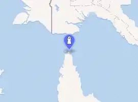
Eborac Island Light is an active lighthouse on Eborac Island, a small rocky island in the Adolphus Channel just off Cape York, the northern tip of Cape York Peninsula, Far North Queensland, Australia. It guides ships into the coastal channel inside the Great Barrier Reef.[1] The concrete structure was built in 1921 and converted to solar power in 1990.
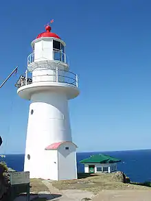
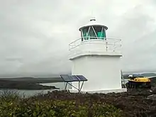 Eborac Island Light, 2007 | |
| |
| Location | Eborac Island Queensland Australia |
|---|---|
| Coordinates | 10°40′55.62″S 142°32′01.07″E |
| Tower | |
| Constructed | 1921 (first) |
| Construction | concrete hut (first) fiberglass current |
| Height | 19 feet (6 m) |
| Shape | square tower with balcony and lantern (first) hexagonal tower |
| Markings | white tower and lantern |
| Power source | solar power  |
| Operator | Australian Maritime Safety Authority |
| Light | |
| First lit | 2012 (current) |
| Focal height | 127 feet (39 m) |
| Lens | Chance Brothers 400 mm Fresnel lens |
| Intensity | white: 3,500 cd red: 700 cd G. 700 cd |
| Range | white: 11 nmi (20 km) red: 8 nmi (15 km) green: 8 nmi (15 km) |
| Characteristic | Fl (2) WRG 10s. |


Eborac Island
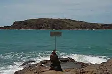
Eborac Island is located in the Adolphus Channel, a channel at the northeastern end of Cape York Peninsula and southeastern portion of the Torres Strait. The island is part of the Manar Group of the Torres Strait Islands. It is visible just across from Cape York, the northernmost point on the Australian continent. Its native name is Dyāra.[2]
Structure and display
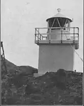
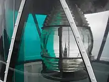
Eborac Island Light was established in 1921. It was converted to solar power on 8 August 1990.[3]
The structure is a square concrete hut, 3 metres (9.8 ft) from the base to the platform. It is topped by a Chance Brothers 7 feet 11 inches (2.41 m) diameter lantern room. Both are painted white, and the total height is 6 metres (20 ft). A Helipad is nearby.[3]
The current light characteristic is two flashes, separated by two seconds, every 10 seconds, colored white, red or green depending on direction (Fl.(2)W.R.G. 10s). White, visible for 11 nautical miles (20 km; 13 mi), is shown at 267°30′-281°, 288°30′-000° and 135°-252°. Green, visible for 8 nautical miles (15 km; 9.2 mi), is shown at 252°30′-267°30′ and 000°-135°. Red, visible for 8 nautical miles (15 km; 9.2 mi), is shown at the small middle sector, 281°-288°30′.[4] The apparatus is a Chance Brothers 400 mm focal length Fresnel lens. The light source is a solar powered 12 Volt 35 Watt Halogen lamp and the intensity is 3,700 cd for the white light and 700 cd for the red and green ones.[3]
Site operation and visiting
The site and the tower are operated by the Australian Maritime Safety Authority. The island is accessible only by boat, and both the site and the tower are closed to the public. The lighthouse is, however, visible from the tip of Cape York, which can be reached by four wheel drive[1]
See also
References
- Rowlett, Russ. "Lighthouses of Australia: Far North Queensland". The Lighthouse Directory. University of North Carolina at Chapel Hill. Retrieved 14 November 2010.
- John MacGillivray (1852). Narrative of the Voyage of H.M.S. Rattlesnake. 2. p. 314. ISBN 9781402172076.
- "Eborac Island Light, QLD, AN250-01" (PDF). Aids to Navigation Schedule Issue 15. Australian Maritime Safety Authority. June 2006.
- List of Lights, Pub. 111: The West Coasts of North and South America (Excluding Continental U.S.A. and Hawaii), Australia, Tasmania, New Zealand, and the Islands of the North and South Pacific Oceans (PDF). List of Lights. United States National Geospatial-Intelligence Agency. 2010. p. 193.
External links
 |
Wikimedia Commons has media related to Eborac Island Light. |
- "List of Lighthouses of Queensland". Lighthouses of Australia. Lighthouses of Australia Inc.
- Searle, Garry. "List of Lighthouses - Queensland". Lighthouses of Australia. SeaSide Lights.
List of Torres Strait topics | |||||||||||||||||||
|---|---|---|---|---|---|---|---|---|---|---|---|---|---|---|---|---|---|---|---|
| Torres Strait Islands, islets, and cays |
| ||||||||||||||||||
| People, culture, communities and languages |
| ||||||||||||||||||
| Governance and legal matters |
| ||||||||||||||||||
| Buildings and structures | |||||||||||||||||||
| Other | |||||||||||||||||||

| South East Coast |
|  | ||||
|---|---|---|---|---|---|---|
| Central Coast | ||||||
| North Coast | ||||||
| Far North Coast | ||||||
| Torres Strait | ||||||
| ||||||