Estrie
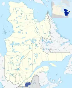
The Estrie (French pronunciation: [ɛstʁi]) is an administrative region of Quebec that replaced the Eastern Townships. Estrie, a French neologism, was coined as a derivative of est, "east". Originally settled by anglophones, today it is about 90 per cent francophone.[2] Anglophones are concentrated in Lennoxville, home of the region's only English-speaking university, Bishop's University. The Eastern Townships School Board runs 20 elementary schools, three high schools, and a learning centre.[3]
Estrie | |
|---|---|
 | |
| Country | .svg.png.webp) Canada Canada |
| Province |  Quebec Quebec |
| Regional County Municipalities (RCM) and Equivalent Territories (ET) | |
| Government | |
| • Regional conference of elected officers | Jacques Demers (President) |
| Area | |
| • Land | 10,212.00 km2 (3,942.88 sq mi) |
| Population (2016)[1] | |
| • Total | 319,004 |
| • Density | 31.2/km2 (81/sq mi) |
| Demonym(s) | Estrien(ne) |
| Time zone | UTC-5 (EST) |
| • Summer (DST) | UTC-4 (EDT) |
| Postal code | |
| Area code | 819 |
| Website | estrie.gouv.qc.ca |
Economy
While the economy of the area is mainly based on agriculture, forestry, and mining,[4] tourist attractions include four Sépaq parks: Yamaska, Mont-Orford, Frontenac, and Mont-Mégantic,[5] ski resorts at Mont Brome and Mont Orford, and agritourism.
Subdivisions
Regional County Municipalities
| Regional County Municipality (RCM) | Population 2016 Canadian Census[6] |
Land Area | Density (pop. per km2) |
Seat of RCM |
|---|---|---|---|---|
| Coaticook | 18,497 | 1,339.80 km2 (517.30 sq mi) | 13.8 | Coaticook |
| Le Granit | 21,462 | 2,735.21 km2 (1,056.07 sq mi) | 7.8 | Lac-Mégantic |
| Le Haut-Saint-François | 22,335 | 2,273.39 km2 (877.76 sq mi) | 9.8 | Cookshire-Eaton |
| Le Val-Saint-François | 30,686 | 1,403.43 km2 (541.87 sq mi) | 21.9 | Richmond |
| Les Sources | 14,286 | 787.13 km2 (303.91 sq mi) | 18.1 | Val-des-Sources |
| Memphrémagog | 50,415 | 1,319.29 km2 (509.38 sq mi) | 38.2 | Magog |
Equivalent Territory
| Equivalent Territory (ET) | Population 2016 Canadian Census[6] |
Land Area | Density (pop. per km2) |
Seat of ET |
|---|---|---|---|---|
| Sherbrooke | 161,323 | 367.10 km2 (141.74 sq mi) | 456.0 | Sherbrooke |
Demographics
Largest cities or towns in Estrie 2016 census | |||||||||
|---|---|---|---|---|---|---|---|---|---|
| Rank | Regional county municipality | Pop. | Rank | Regional county municipality | Pop. | ||||
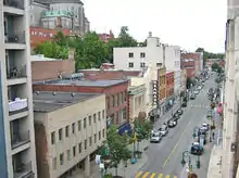 Sherbrooke 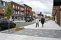 Magog |
1 | Sherbrooke | Sherbrooke | 161,323 | 11 | Ascot Corner | Le Haut-Saint-François | 3,158 | 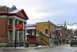 Coaticook  Val-des-Sources |
| 2 | Magog | Memphrémagog | 26,669 | 12 | Compton | Coaticook | 3,131 | ||
| 3 | Coaticook | Coaticook | 8,698 | 13 | Stanstead | Memphrémagog | 2,788 | ||
| 4 | Val-des-Sources | Les Sources | 6,786 | 14 | Weedon | Le Haut-Saint-François | 2,670 | ||
| 5 | Lac-Mégantic | Le Granit | 5,654 | 15 | Valcourt | Le Val-Saint-François | 2,165 | ||
| 6 | Windsor | Le Val-Saint-François | 5,419 | 16 | Waterville | Coaticook | 2,121 | ||
| 7 | Cookshire-Eaton | Le Haut-Saint-François | 5,393 | 17 | Hatley | Memphrémagog | 2,106 | ||
| 8 | Danville | Les Sources | 3,826 | 18 | Potton | Memphrémagog | 1,852 | ||
| 9 | East Angus, Quebec | Le Haut-Saint-François | 3,659 | 19 | Eastman | Memphrémagog | 1,843 | ||
| 10 | Richmond | Le Val-Saint-François | 3,232 | 20 | Dudswell | Le Haut-Saint-François | 1,727 | ||
School Districts
Francophone:
- Commission scolaire des Hauts-Cantons (Coaticook, East Angus and Lac-Mégantic).
- Commission scolaire de la Région-de-Sherbrooke
- Commission scolaire des Sommets
Anglophone:
References
- "Census Profile, 2016 Census: Estrie [Economic region], Quebec". Statistics Canada. Retrieved November 22, 2019.
- "Eastern Townships". Encyclopedia Britannica. Retrieved 10 November 2020.
- Elementary schools Archived 2010-11-30 at the Wayback Machine and High Schools Archived 2010-10-27 at the Wayback Machine, Eastern Townships School Board, accessed 19 November 2010.
- "Community Snapshot – Eastern Townships" (PDF). The Community Information Database. Retrieved 10 November 2020.
- "Best of the Townships". Tourism Eastern Townships. Retrieved 10 November 2020.
- "Population and Dwelling Count Highlight Tables, 2016 Census". Statistics Canada. Retrieved December 4, 2019.
External links
- Estrie (05), Government of Quebec
- Tourism Eastern Townships
- Estrieplus.com, Web Portal
- CRÉ
| Regional county municipalities and equivalent territories | |
|---|---|
| Municipalities | |
| Subdivisions | |
|---|---|
| Communities | |
| Major cities | |
| Regions | |
Portal:Canada | |
Authority control  | |
|---|---|
| General | |
| National libraries | |
| Other | |